Hong Kong Special Administrative Region features roughly 640+ km of maintained hiking trails, including hundreds of kilometres of scenic, mountainous routes within its country parks. Hong Kong is one of the safest cities—solo running is no problem.
These hiking trails attract many hikers, including locals, from China, and overseas. Since 2024, the government has started to improve transportation to bring in more visitors to the country parks.
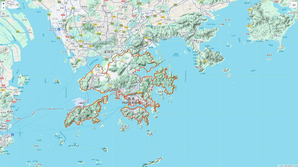
The route proposal here covers 616 km. It laps around the outermost periphery of all major land areas: Kowloon (mountain views + Victoria Harbour seaside), New Territories mainland, Lantau Island (trails, beaches, peaks), and Hong Kong Island (as close as possible along the shore, some overgrown sections requiring back-and-forth searching). Transitions use most natural walks (e.g., northern Kowloon mountains like Lion Rock/Wilson Trail to New Territories south; northwest New Territories to Lantau via Tung Chung/airport zone; Lantau to Hong Kong Island via western/northern connections like near Tsing Yi or harbour crossings' pedestrian paths). The full loop creates a complete Hong Kong Special Administrative Region circumnavigation on foot.
The route is fixed with minor deviation allowed (for all sections), runners must follow parameters. Minor deviation allowed for road blocks/repairs. Clockwise/anticlockwise whole or part allowed.
No transportation allowed throughout.
Attraction of the route
- Epic scale: likely 20–40+ days self-supported (New Territories multi-week; Kowloon 1–2 days; Lantau 4–5 days; Hong Kong Island 2–4 days).
- Diverse: urban promenades (Kowloon/HK Island), up and down numerous hills (New Territories/Lantau), beaches (Pui O, Cheung Sha), old villages (Tai O, Mui Wo), Victoria Harbour views, and all of Hong Kong's highest peaks.
- Trails well-traveled in parts (Lantau with half-km posts), park facilities (benches, bathrooms, camping).
- Pretty straightforward running in many sections: run hours for miles, carry nutrition drink, rest/refuel at convenience stores (Octopus accepted), restart exploration.
Route parameters
- Start = a point at seashore or loop point (e.g., start fromTung Chung Ferry Pier for Lantau, Yau Tong MTR B2 for Kowloon, Mei Ching Road roundabout for New Territories, or HK Island shore point. Can easily get good public transport back to last finishing point to continue the route).
- Transition = most natural walks: lap Kowloon outermost → north mountains to New Territories periphery → northwest to Lantau outermost → suitable natural/water-edge connection to HK Island shore circumnavigation (close as possible to coastline) → return to close full loop.
- End = starting point.
- The gpx route is done on foot.
Section Bases
- Kowloon:B2 Exit Yau Tong MTR, Sam Ka Tsuen Pier, Wilson Trail posts, Lion's Pavilion, MacLehose 101-115.5, Butterfly Valley, West Kowloon Promenade, Avenue of Stars, Tsim Sha Tsui Promenade, Hung Hom Promenade, Kai Tak Runway Park (required), Kwun Tong Promenade, ... back to B2.
- New Territories:Outermost periphery per original (roundabout Mei Ching/Container Port South as reference).
- Lantau:north-west to north-east shores, requires running to the rim of Hong Kong Boundary Crossing Facilities Artificial Island.
- Hong Kong Island:Run as close as possible along the shore ; focus on coastline perimeter (some overgrown, searching required).
Start/End & Rules
Start from a loop/seashore point. End at start. Routes “fixed with minor deviation” (Kowloon/NT) or “open” (Lantau/HK Island shore). Required touches: Kai Tak Runway Park, Lantau artificial island rim. No transportation sections. Sleep/rest allowed. Resupply: convenience stores for food/water (using Hong Kong stored value cards, credit cards, etc); public fountains in Kowloon.
How it goes
Start from a point, lap outermost of Kowloon → New Territories → Lantau → Hong Kong Island shore, end where started. Straightforward running overall—carry nutrition, rest/refuel at stores, restart.