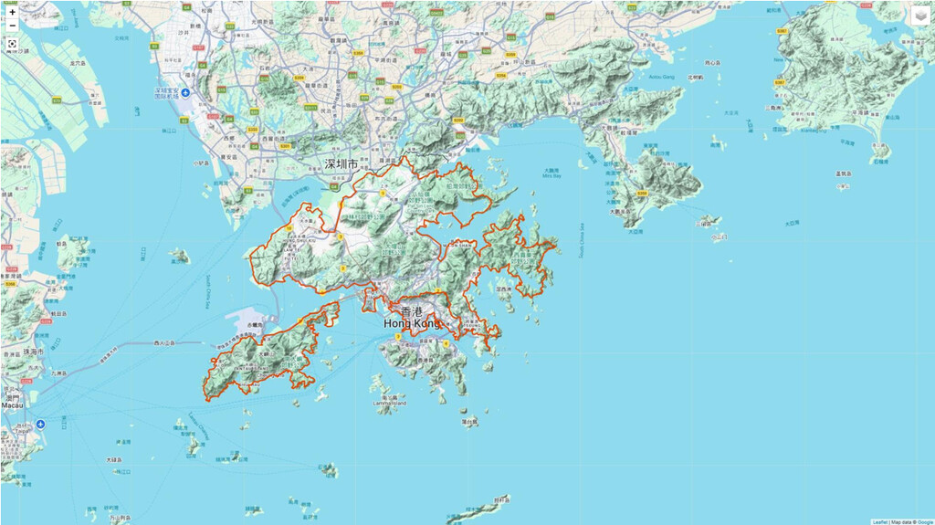
Hong Kong SAR China has a total area of 1,108 sq km (428 sq mi), of which 3.16% is water. Hong Kong is administratively divided broadly into roughly 4 parts: Kowloon, New Territories, Kowloon, and Hong Kong Island. This proposed route runs along the periphery of Kowloon, New Territories, and Lantau Island. The route forms a loop. Time is likely 15-30+ days.
The route is fixed with minor deviation allowed, and runners have to follow route parameters. Since the goal is to reach from the start back to the start, minor deviation is allowed as road block and repairs varies day to day. Clockwise the whole or part, and anticlockwise the whole or part, are allowed.
No transportation is allowed throughout.
Attraction of the route
- Time needed: likely 15–30+ days depending on pace (New Territories multi-week; Kowloon 1–2 days; Lantau four to five days).
- The trails are well-traveled in many sections (especially Lantau), many with park posts marking every half kilometer.
- There are park benches, location maps, bathrooms, fire pits, picnic tables, and tent camping areas for the use of hikers (more on Lantau).
- Nice scenery and beautiful views; nice beaches at Pui O and Changsha on southern Lantau.
- Mui Wo on the east end and Tai O on the west end offer old village attractions.
- View Hong Kong's second and third highest peaks (Lantau).
- Get good views of whole Kowloon from mountain range and along Victoria Harbour seaside.
- Epic urban-to-rural transition covering Hong Kong's major landmasses.
- The route is pretty straightforward running. Run a few hours for scores of miles, carrying one bottle of nutrition drink. Take time to rest, refuel food and drinks from convenience store, then restart the exploration. For payments, convenience stores accept Stored Value cards (Octopus). Running solo is no problem as Hong Kong is one of the safest cities in the world.
Route parameters
- Start = a point at seashore or loop point (e.g., adapt from B2 Exit, Yau Tong MTR Station 油塘站 B2 for Kowloon; or roundabout between Mei Ching Road and Container Port Road South for New Territories; or Tung Chung New Development Ferry Pier 東涌新發展碼頭 for Lantau integration – choice “open” for linking).
- Transition = most natural walks: lap around outermost of Kowloon first → link north via mountains (Wilson / MacLehose near Lion Rock / Tai Lo Au) to New Territories periphery → link northwest (Tung Chung / airport zone) to Lantau outermost periphery, returning to close loop.
- End = the starting point.
- On foot.
Kowloon section bases (for clarity, required to include Kai Tak Runway Park 啟德跑道公園; not required to include Ngong Shuen Chau Barrack closed area)
B2 Exit, Yau Tong MTR Station 油塘站 B2, ... (full original list including Wilson Trail posts, Lion's Pavilion, MacLehose Trail 101-115.5, Butterfly Valley, West Kowloon Waterfront, Avenue of Stars, Tsim Sha Tsui Promenade, Hung Hom Promenade, Kwun Tong Promenade, ... back to B2).
New Territories section route
The route runs along the outermost periphery of New Territories. (Follow original parameters, starting/ending near Mei Ching Road / Container Port Road South roundabout.)
Lantau Island section bases
Bases at north-west shore: Tung Chung New Development Ferry Pier 東涌新發展碼頭, ... (full original lists for north-west, west, south, east, north-east shores, required to touch rim of Hong Kong Boundary Crossing Facilities Artificial Island 港珠澳大橋香港口岸人工島).
Start/End & Rules
Start from a point of the loop / seashore. End at starting point. Routes are “fixed with minor deviation allowed” (Kowloon/New Territories) or “open” in spirit (Lantau), but parameters followed. No transportation allowed. Sleep/rest allowed. Food/water resupply from convenience stores; water also from public sterilized fountains.
How it goes
Start to run from a point, lap around outermost of Kowloon, New Territories, then Lantau, end where started. A pretty straightforward running. Take time to rest, refuel from convenience store, restart exploration.
This is a route covering Hong Kong's major land outer edges (~529 km).