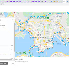
The Hong Kong Special Administrative Region comprises of 3 regions, Hong Kong Island, Kowloon and New Territories. Kowloon is located directly north of Hong Kong Island across Victoria Harbour. It is bordered by a mountain range, including Tate's Cairn and Lion Rock to the north, and Victoria Harbour to the south. The total land area is about 67 square kilometres (26 sq. ml). The Kowloon Circumnavigation route is interesting in getting a good view of the whole of Kowloon from the mountain range, and run along the seaside of Victoria Harbour.
The following information is provided by the runner Chris Mak:
Q:
What is the name of this route?
A:
Kowloon Circumnavigation (Hong Kong)
Q:
What is the nick-name of this route?
A:
Round the Kowloon
Q:
Can you provide clear parameters that others can follow.
A:
route parameters
- Start = a point of the loop
- transition = lap around the outermost natural walkables of the Kowloon
- end = the starting point
- on foot
Q:
What is the boundary of Kowloon?
https://www.openstreetmap.org/relation/10268797#map=13/22.3223/114.1905
Q:
How would the proposed route be look like by imagination?
A:
Following is the proposed route with GPX attachment in the name Route.GPX
https://connect.garmin.com/modern/course/52907951
Q:
Can you list those bases on the route for clarity.
A:
Bases
B2 Exit, Yau Tong MTR Station油塘站B2
Sam Ka Tsuen Pier三家村碼頭
Lei Yue Mun Praya Road East Century old tree鯉魚門海傍道東百年古樹
Che Ting Tsuen輋頂村
Junk Bay Chinese Permanent Cemetery access road將軍澳華人永遠墳場通道
Wilson Trail distance-post 20-31.5衞奕信徑標距柱20-31.5
On Sau Road end-to-end安秀道
Fei Ngo Shan Road end-to-end飛鵝山道
Tai Lo Au(Tate's Pass)大老坳
Wilson Trail distance-post 40-46.5衞奕信徑標距柱40-46.5
Lion's Pavilion獅子亭
MacLehose Trail distance-post 101-115.5麥理浩徑標距101-115.5
Tai Po Road大埔公路(section from Cheung Yuen Road junction to Caldecott Road junction長源路口至郝德傑道口)
Caldecott Road end-to-end郝德傑道
Butterfly Valley Fresh Water Primary Service Reservoir蝴蝶谷食水主配水庫
St Raphael Cemetery天主教聖辣法厄爾墳場
Wing Tak Road(section from 22°20'26.64"N 114°08'60"E to 22°20'24.37"N 114°08'30.79"E)
Butterfly Valley Interchange蝴蝶谷交匯處
Mei Lai Road美荔道
Lai Wan Roa荔灣道
Lai King Hill Road荔景山路
Ching Lai Commercial Centre covered footbridg清麗商場有蓋行人天橋
Lai Chi Kok Park Skatepark 荔枝角滑板公園極限運動場
Tat Mei Road end-to-end達美路
Stonecutters Island Sewage Treatment Works昂船洲污水處理廠
Lai Ying Street荔盈街
Cheung Sha Wan Wholesale Food Market長沙灣副食品批發市場
Cheung Sha Wan Wholesale Marine Fish Market長沙灣魚類批發市場
Marine Police Operational Base水警行動基地
praya of The Long Beach浪澄灣海旁
Hoi Fai Road Promenade end-to-end海輝道海濱花園
West Kowloon Cultural District Pet Dog Garden西九文化區寵物犬公園
West Kowloon Competition Pavilion香港新晉建築設計師比賽展亭
West Kowloon Waterfront Promenade西九龍海濱長廊
Western Harbour Crossing Ventilation Building西區海底隧道通風大樓
Xiqu Centre戲曲中心
Star Ferry Pier天星碼頭
Former Kowloon-Canton Railway Clock Tower前九廣鐵路鐘樓
Hong Kong Cultural Centre Promenade Bridge香港文化中心海旁觀光天橋
Avenue of Stars end-to-end星光大道
Tsim Sha Tsui Promenade end-to-end尖沙咀海濱花園
Hung Hom Promenade end-to-end紅磡海濱花園
Hung Hom Ferry Pier紅磡渡輪碼頭
Whampoa Promenade end-to-end黄埔海濱花園
King Wan Street Leisure Path (Seafront) 景雲街休閒小徑(海傍)
Kowloon City Ferry Pier九龍城渡輪碼頭
Kowloon City District Council sitting out area at Hing Yan Street waterfront興仁街海旁九龍城區議會休憩處
Ma Tau Kok Road馬頭角道
To Kwa Wan Road土瓜灣道
Shing Kai Road承啟道
Kai Fuk Road啟福道
Kai Tak Bridge啟德橋
Kai Tak Runway Park啟德跑道公園
Government Flying Service Kai Tak Division政府飛行服務隊啟德分部
Kai Tak Cruise Terminal Park啟德郵輪碼頭公園
Hong Kong Children's Hospital香港兒童醫院
Kwun Tong Promenade end-to-end觀塘海濱花園
Kwun Tong Ferry Pier觀塘渡輪碼頭
Cha Kwo Ling Road almost whole茶果嶺道
B2 Exit, Yau Tong MTR Station油塘站B2
Q:
-Where does the run officially start?
A:
Start to run from a point of the loop.
Q:
-Where did the run officially start in 2018?
A:
B2 Exit, Yau Tong MTR Station油塘站B2
Q:
Where does it end?
A:
The starting point.
Q:
Where did it end in 2018?
A:
B2 Exit, Yau Tong MTR Station油塘站B2
Q:
-Is the route "open"?
A:
The route is “fixed with minor deviation allowed”.
Q:
or does the runner have to follow a particular route?
A:
route parameters are to be followed
Q:
Since the goal is to reach from the start back to the start, it seems logical that someone could use whatever route they want to do that?
A:
Minor deviation is allowed, as road block and repairs varies day to day.
Clockwise the whole or part and antivlockwise the whole or part are allowed
Q:
If the runner has to follow a particular route, please describe the route turn by turn.
A:
route parameters are to be followed.
Q:
-The original runner reached the Ngong Shuen Chau Barrack昂船洲軍營in the 2018 trial.
A:
The original runner did.
Q:
Are we going to require future runners to touch the Ngong Shuen Chau Barrack昂船洲軍營? The route looks like extra loop or out & backs.
A:
Not required to touch.
Q:
-The original runner reached the Kai Tak Runway Park啟德跑道公園in the 2018 trial.
A:
The original runner did.
Q:
Are we going to require future runners to touch the Kai Tak Runway Park啟德跑道公園? The route looks like extra loop or out & backs.
A:
Required to touch.
Q:
What are the sections which it is allowed to take transportation other than running?
A:
No section is allowed.
Q:
What did you do?
A:
Start to run from a point of the loop, lap around the outermost natural walkables of the Kowloon, end at where I start from.
Q:
Did anyone run with you for any distance?
A:
Not anyone run with me for any distance.
Q:
Did you resupply with food and, if so, how?
A:
Food resupply was not taken.
Q:
Where does one get water?
Plenty of coin vending machine, convenience store and public sterilized-water fountain along the route.
Q:
Where did you get water?
public sterilized-water fountain
Q.
What were the summary of the 09 Apr 2018 trial?
A:
Distance(Km) = 71.09
Start: 09 Apr 2018 Mon 8:58pm
Duration = 13:37:17
Elevation gain(m) = 1317
Total calorie(Kcal) = 3716
https://connect.garmin.com/modern/activity/2613665831

