Submitted by Jamie Stephenson:
A lap of the island of Malta. This is not a lap of the country of Malta as that would include the islands of Comino and Gozo as well. The route measures about 137km with 3,100m ascent (mapped on strava). Start and finish where ever you like but the LOVE sign in Saint Julian is a good recommendation.
The route can start from anywhere on the coast of Malta and must then take the runner around the island (not including the islands of Comino and Gozo). This should be the longest way around i.e. when a road or footpath loops out onto a headland then a runner is expected to follow it. This is particularly applicable through Senglea, south of Valletta. You are not expected to run out and back along dead-end trails or roads. When there is no entrance along a road or trail e.g. military base or docks then the next longest route should be taken.
While I am familiar with a lot of the route there are areas where I am trusting the map. I expect to find some of the paths non-existent and having to improvise a bit on the day! This is according to mapping it on Strava and trying to correlate that with google maps:
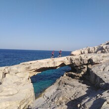
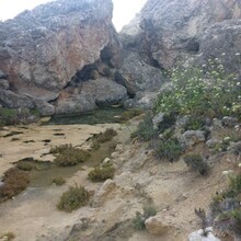
Starting at the LOVE sign in St Julians, pass down the ramp and around Portomaso marina. Take Dragnara road to St Georges bay and climb up the hill. Turn left onto Triq il-Mediterran and then right onto Triq Manwel Buhagiar. Turn left onto the footpath and follow this hugging the coast past Madiena tower until you join a road. Follow this past the east side of Splash and Fun to join Coast road. Follow this for 5km until you reach Kennedy grove when you turn right onto footpath/trail until you find Qawra road. Follow this all the way through Bugibba and into St Pauls Bay. Here you need to remain on the road closest to the coast until re-joining the main road (St Pauls Street) heading into Ix-Xemxija. At the roundabout when you are leaving Ix-Xemxija take a right to find a footpath that joins Triq il-Mistra. This subsequently turns to footpath which you use to hug the coast once again past Imgiebah Bay to join Ix-Xatt ta Santa Marija. Follow this to find Ghadira bay. Run along the length of the beach and then take a right past Mellieha Bay hotel onto trail that takes you north westerly. Join Triq Dahlet Ix-Xmajjar before heading out onto the headland, around the white tower and back onto Triq Ir-Ramla. Follow footpath and trails past little Armier beach, onto the headland and past Velodrome battery. Continue along coastal footpath and road until you join highway 1 and follow this to the ferry terminal. At paradise Bay resort, you can join a footpath that takes you past paradise bay lido, across Triq Ghajn Tuta to join Triq Tad-Dahar. After 750m drop left down some steps to join a further footpath. Zigzag your way down to Popeye village and follow the road for a further 1.5km before turning right onto more trail. Take the route that follows closest to the coast, out onto the headland and into Golden Bay. Make your way across to Ghajn Tuffieha and continue to follow the trail past Gnejna Bay and onto the road that runs above Fomm Ir-Rih. Join the coastal trail once again and follow the coast as tightly as possible until you climb a long way up to join a road and subsequently onto Panoramika at 64km. Follow this for 4km before dropping down and improvising your way to Caqnu Quarry. Follow the 140 to Ghar Lapsi where you rejoin trail that takes you past the temples and up onto the 117. Follow this towards Zurrieq until you reach Triq L-Gherian where you turn back on yourself and head towards the Garden of Eden. Run onto Triq L-Iskultur Fabri and then Triq Li-Pluvieri, through the industrial estate and onto 142. After 400m turn right onto Fortizza and then onto 143. Follow this then the 144 through Birzebbugia. Join the 138 into Marsaxlokk taking the long way around Fort San Lucian. Join Triq il-power Station and then inland to Triq il-Delimara. At Fort Delimara turn left onto coastal trail and follow this to Xrobb L-ghagin nature park. Run a lap of the park and then rejoin the coastal trail into Marsaskala. Here you join Triq Is-Salini and then 134 before rejoining coastal trail through Ix-Xghijra and then Fort Rinella. You now come into the Three cities and you need to follow the road closest to the water. This includes a trip out into Senglea, around the headland and back inland along Monsinjur Panzevecchia and join the 24. Head west keeping MCAST to your left, around dock 7 and into Marsa. Hug the coast past Floriana, around Valletta (including a lap of Fort St Elmo) and back along its northern edge until you hit Triq L-imsida. Follow this to the large roundabout when you turn right past Busy Bee and into Ta-Xbiex. Keep the sea on your right and follow the promenade into Sliema. Follow Il-Fortina through the tunnel and back to the promenade. This will now lead you all the way back to the LOVE sign.
Malta AND Gozo:
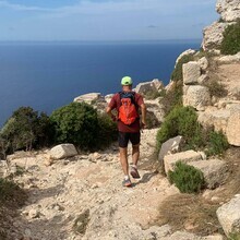
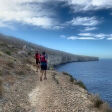
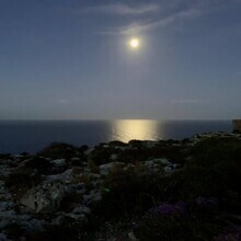
This route hugs the coast of Malta and Gozo for 187.8km (3600 m vertical), going round both. It includes 2 short boat rides between Malta and Gozo (included in your total elapsed time for the FKT). The route is about 70% trail - some of it quite technical - and 30% road. It includes some spectacular coastal paths - cliffsides, crumbly clay slopes - and some stretches through beautiful, coastal, fortified mediaeval towns like the 3 cities (Cospicua, Senglea and Vittoriosa), and the capital Valletta. It starts in Independence Gardens in Sliema, hugging the coast for 39 km Northwestwards to Cirkewwa. After crossing to Mgarr, there is 51 kms clockwise round the coast of Gozo. This section includes many highly technical trails with quite a few steep ascents. After the short boat ride down to Cirkewwa (Malta) again and set off down the West coast of the island, right round the Southern tip at Birzebbuga, through to the 3 cities and Valletta, and then the final stretch to the Independence Gardens in Sliema once again. If you google image search 'Malta Coast' or 'Gozo Coast' you will find hundreds of beautiful pictures that are all along the route :)