The Hong Kong Special Administrative Region comprises of 3 regions: Hong Kong Island, Kowloon and New Territories. Kowloon is located directly north of Hong Kong Island across Victoria Harbour. It is bordered by a mountain range, including Tate's Cairn and Lion Rock to the north, and Victoria Harbour to the south. The total land area is about 67 square kilometres (26 sq mi).
The Round Kowloon Route is 71.09 km long and New Territories Route is 344.41 km long.
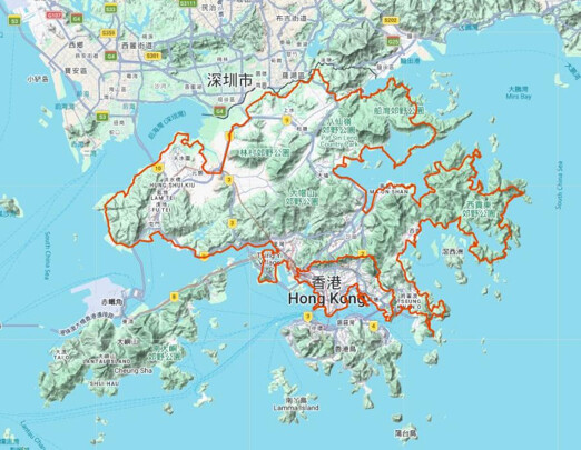
The Kowloon Route is interesting in getting a good view of the whole of Kowloon from the mountain range, and run along the seaside of Victoria Harbour. It laps around the outermost periphery of Kowloon first, then connects with the New Territories Route via the northern mountain range (e.g., Lion Rock, Tate's Cairn areas using Wilson Trail / MacLehose Trail sections) to the outermost periphery of New Territories mainland.
The route is fixed with minor deviation allowed, and runners have to follow route parameters. Since the goal is to reach from the start back to the start, minor deviation is allowed as road block and repairs varies day to day. Clockwise the whole or part, and anticlockwise the whole or part, are allowed.
No transportation is allowed throughout. The route is pretty straightforward running. Run a few hours for scores of miles, carrying one bottle of nutrition drink. Take time to rest, refuel food and drinks from convenience store, then restart the exploration. For payments, convenience stores and public transport accept Stored Value cards (Octopus). Running solo is no problem as Hong Kong is one of the safest city in the world.
Plenty of coin vending machine, convenience stores and public sterilized-water fountain along the route.
Start/End details
Start to run from a point of the loop. End at the starting point. The route is “fixed with minor deviation allowed”. Required to touch Kai Tak Runway Park 啟德跑道公園 (Kowloon). Not required to touch Ngong Shuen Chau Barrack 昂船洲軍營.
Route parameters
- Start = any point of the route (e.g., for Kowloon Route, start from B2 Exit, Yau Tong MTR Station 油塘站) For New Territories route, start from the roundabout between Mei Ching Road and Container Port Road South. Starting from here also links northern Kowloon mountain boundary like Lion Rock / Tai Lo Au / Wilson Trail sections).
- Transition = lap around the outermost natural walks of Kowloon first (following its parameters), then cross/link via most natural walks in the northern mountain range (e.g., Wilson Trail distance-posts near Tai Lo Au, MacLehose Trail near Lion Rock / Butterfly Valley areas) to circumnavigate New Territories outermost periphery, returning to close the full loop.
- End = the starting point.
- On foot.
Kowloon section bases
B2 Exit, Yau Tong MTR Station 油塘站 B2, Sam Ka Tsuen Pier 三家村碼頭, Lei Yue Mun Praya Road East Century old tree 鯉魚門海傍道東百年古樹, Che Ting Tsuen 輋頂村, Junk Bay Chinese Permanent Cemetery access road 將軍澳華人永遠墳場通道, Wilson Trail distance-post 20-31.5 衞奕信徑標距柱20-31.5, On Sau Road end-to-end 安秀道, Fei Ngo Shan Road end-to-end 飛鵝山道, Tai Lo Au (Tate's Pass) 大老坳, Wilson Trail distance-post 40-46.5 衞奕信徑標距柱40-46.5, Lion's Pavilion 獅子亭, MacLehose Trail distance-post 101-115.5 麥理浩徑標距101-115.5, Tai Po Road 大埔公路 (section from Cheung Yuen Road junction to Caldecott Road junction 長源路口至郝德傑道口), Caldecott Road end-to-end 郝德傑道, Butterfly Valley Fresh Water Primary Service Reservoir 蝴蝶谷食水主配水庫, ... (full list as original, including required touch Kai Tak Runway Park 啟德跑道公園, West Kowloon Waterfront Promenade, Avenue of Stars, Tsim Sha Tsui Promenade, Hung Hom Promenade, Kwun Tong Promenade, ... back to B2 Exit, Yau Tong MTR Station).
New Territories section
The route runs along the outermost periphery of New Territories. Suggest to start and endinear the southern dividing line roundabout between Mei Ching Road and Container Port Road South, covering the full mainland loop.