This point-to-point route connects two emblematic towns of the Loire and Ardèche regions — from the Saint-Étienne Town Hall to the Annonay Town Hall — following mostly the GR42, a long-distance trail that runs from Saint-Étienne all the way to Aigues-Mortes.
Starting in front of Saint-Étienne’s City Hall, the route quickly leaves the urban environment to climb into the Parc du Pilat.
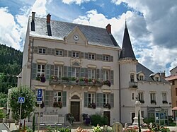
Following the GR42, it passes through the town of Bourg-Argental and follows its climb towards Burdignes, winding through beech and fir forests, open farmland, and panoramic ridgelines overlooking the Pilat mountains.
From Burdignes, the trail climbs towards the Croix de Chirol, before descending toward Montmiandon, marking the approach to the Annonay valley.
The final kilometers take you through the narrow streets of Annonay’s historic district, finishing at the Town Hall — a symbolic end to this FKT route.
Highlights:
-
Official Town Hall to Town Hall route
-
Full crossing of the Pilat Massif via the GR42
-
Diverse terrain: urban start, forest, ridgelines, and rural valleys
-
Scenic viewpoint at the Croix de Chirol
-
Finish through the historic center of Annonay
Notes: