Vale of Leven Tour route description
The Vale of Leven Tour is a 55km circular route around the Vale of Leven, West Dumbartonshire, connecting the highest points in the area and taking in historical sites as well as geological landmarks. The route can be run in the clockwise or anticlockwise direction. In the anticlockwise direction the route has an elevation gain of 1380m. In June 2025, I ran it clockwise during the development of this round and while the route differed slightly from the final version the elevation gain was closer to 1490m. But an official clockwise round has yet to be completed.
I started my anticlockwise Vale of Leven Tour on Aug 23rd, 2025, at 8am at the Carman Hill Fort, an Iron Age fort overlooking the Vale. I chose this as my starting point for personal convenience. I was back at Carman at 17:35:15 after 9 hours 35 minutes and 15 seconds (female/ unsupported). The circular nature of the route allows for various possible starting points with easy access. I will discuss start/ ends point later after the route description.
The following route description is for the anticlockwise direction:
From Carman Hill Fort (244m) follow the path southwest down the hill to Carman Quarry and to a dirt road that leads to Cardross Road. Go straight across the road and follow a path southwest towards the transmitters until you reach a wall. You can see a little lochan on the other side of the wall. Turn left at the wall and follow a path east, then southeast until there is a gap in the wall. Turn south to reach the trig point south of Carman Reservoir at 161m. Return to the gap in the wall and follow a path north until you reach another path leading to the reservoir. You can see two tall trees on your left. This part can be a little fiddly, especially in the summer when the bracken is high, but I incorporated the trig into the route to avoid having to run on Cardross Road. Cars tend to go very fast here.
Turn east towards Carman Reservoir. Along the southern edge of the reservoir you find a path that leads all the way down to Upper Carman Road in Renton. Turn south to get to the footbridge over the A82. Follow Carman Road to Main Street B857, go straight across and take the small footpath, a little north across Main St, down to the River Leven.
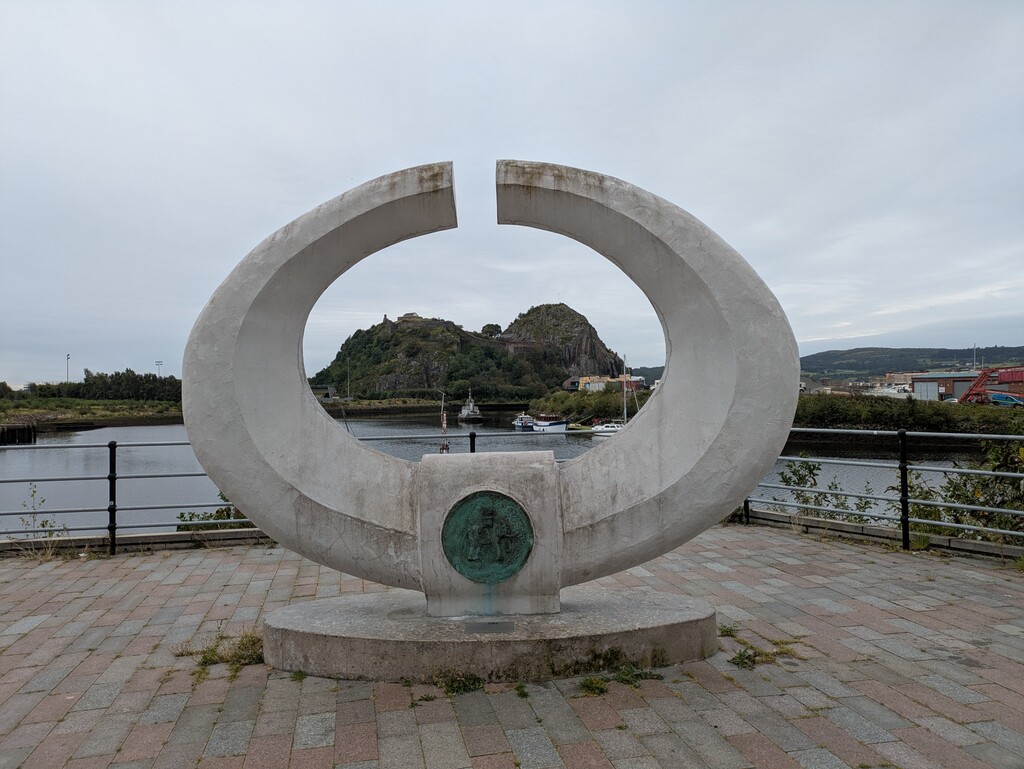
Turn south and follow the River Leven all the way on the National Cycle Route 7 to Bridge Street in Dumbarton. Cross the river and immediately turn south on to Dumbarton Quay and keep following the river. After Lidl Dumbarton Quay turns into Rhydderch Wy. Follow this path to the Dumbarton Football Stadium and Castle Road. Turn south on Castle Road and head to the Castle entrance. There is a trig point in the castle grounds which I would have loved to incorporate into the round, but the entrance is locked out of hours and for the sake of the FKT being accessible 24/7 I omitted it. Touch the wall by the gate, do not entre the castle grounds.
Return on Castle Road and follow it to the intersection with Castlegreen Street (Bangin’ Pizza on the corner). Turn on to Castlegreen Street and follow it all the way to Greenhead Road. Follow Greenhead Road to Stirling Road. Follow Stirling Road north to the Police Station. Directly north of the Police Station is a footpath leading to Overtoun House. Follow this path in the general east/ northeast direction until you get to Overtoun Bridge and the house.
Passed the house, but before the car park, turn north onto the trail that eventually leads into the Kilpatrick Hills. After you pass through a gate remain on the lower trail. You get a great view of the Lang Craigs but do not go up towards them, remain in the north/ northeastern direction. (This path is a brilliant descent running the route clockwise!) Follow the path until you get to another gate. Do not go through the gate but follow a path on the northern side of the fence until you reach an intersecting fence and yet another gate. Go through this gate and entre open hill side with Doughnot Hill straight ahead of you. There is a visible path leading northeast to the top and the trig point (374m).
Touch the trig and leave the top following the path southeast/ south to the dam at Black Linn Reservoir. Cross the dam and at the southern edge of the reservoir you reach a forest track. Follow the track south to the intersection with the Craigs Circular Path and continue south towards Greenland Reservoir No 1 and Loch Humphrey. At the western edge of Loch Humphrey leave the bigger forest road and follow a smaller path alongside the loch.
At the trail intersection south of Loch Humphrey go straight ahead and follow a path southeast until you reach a fence line. Follow the fence east. At the eastern end of the fence turn southeast, The Slacks trig is visible. Go to the trig (365m), touch it and enjoy the view over the Greater Glasgow area (if you have visibility), then retrace your route back to the eastern edge of the fence. Do not follow the fence line back but instead head northwest across Loch Humphrey Burn to a dirt road and follow that back to Loch Humphrey. At the loch turn north and follow the path towards Duncolm.
Bypass Little and Middle Duncolm on the western side (you are welcome to cross over the tops of these two hills if you want to, but the lower path is actually a lot more fun to run than the trod over). Ascend Duncolm from the southeast and touch the trig. At 401m this is the highest point on the route. Descend Duncolm in southwesterly direction until you reach a wall. Stay on the western side of the wall and descend to about 300m where the ground starts to level. There is a path leading north around the foot of Duncolm and towards a forest. Follow the path to a fence. There is a stile but as of June 2025 the gate is down and you can get easily through, cross a small burn and follow the path into the forest. This area can be quite overgrown in the summer and gets very boggy in the winter (!) but there is just one path to follow, you cannot go wrong.
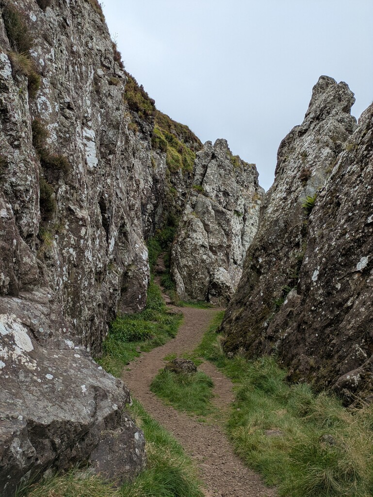
The path through the forest leads in a general northern direction and connects to a dirt road. Keep heading north until you reach the John Muir Way (JMW). Follow the JMW to a gate. After the gate turn east (still on the JMW) but after a few hundred meters look out for a path that heads north to Auchineden Hill. (Local hill runners familiar with the Whangie Whizz know it as the descent of the race route). Once you reach the top of the hill bypass the trig and keep heading north to get to The Whangie. Head to the northern entrance of the ravine on the outside/ western side of the rocks. The Whangie is one of the geological highlights of the route created either by glacial plucking or by the devil himself, depending whether you favour a scientific or mythical explanation. Traverse the ravine from the north then return to Auchineden Hill and touch the trig (357m).
Head south towards Burncrooks Reservoir, at first follow the same way you came up but halfway on the descent look out for a path heading west and follow a lower ridgeline back to the road (Whangie Whizz race route ascent). At the road turn west and head along the northern shore of the reservoir until you reach the dam. Just before the dam take a track heading down and over Burn Crook, head up the other side, through a gate and re-connect with the John Muir Way. Note: from here you will be following the JMW all the way through Balloch to the top of Stoneymollan Road!
Descend from the Kilpatrick Hills following the JMW signs. After Wester Cameron Farm you get on to a 7.5km road stretch, generally head west on Merkins, then turn north, pass Caldarvan Station and turn west again towards Balloch. You can follow JMW signs and you also re-connect with the Cycle Route 7. Signage along this stretch is very clear.
Cross the A811 and follow JMW/ Cycle Route 7 to Balloch Country Park. Touch the wall by the door on the eastern side of the castle. Round the castle, keep following the JMW signs. Head down to Loch Lomond, then turn south to Balloch Road and the bridge over the Leven. After the bridge turn north and follow the JMW to Loch Lomond Shores. When coming out of the Lomond Shores area turn southeast on Old Luss Road, then southwest on Lower Stoneymollan Road. Cross the A82 on the footbridge and connect with Upper Stoneymollan Road. Go through the gate that takes you on to the Stoneymollan dirt track and keep climbing until the hill levels out and you get to the Stoneymollan Muir Cross Stone and a gate.
Do not go through the gate. Turn south and follow a path to Bromley Muir keeping east of the fence line. Touch the Bromley Muir trig (304m). On a clear day this place offers a fantastic view of Ben Lomond, even the Crianlarich Munros, but especially the Highland Boundary Faultline. Continue along the path south. Head up and over Overton Muir. You can see the cairn on Milburn Muir. Descent to a collapsed wall, head up to Millburn Muir, pass the cairn and Carman fort is less than 10m ahead of you.
Congratulations! You have circumnavigated the Vale of Leven!
Why this makes a good FKT route:
The running community in the Greater Glasgow and Clyde area is active and enthusiastic, comprised of an eclectic bunch with preferences for road, hill, trail and ultra-long distances or a little bit of all of these. Yet, there are not many FKT routes in the area and no circular ones. The only FKT routes in the area are transects: John Muir Way, Three Lochs Way, West Highland Way, The Highland Way, Forth and Clyde Canal Towpath.
The Vale of Leven Tour is a brilliant loop for people training for a 100K or 100-mile race and looking for a long day out. It is perfect for anyone wanting to test out the 50-55km distance. It offers a variety of terrain from road, forest track and bog, everything you will encounter at a typical ultramarathon in Scotland. It was perfect preparation for my Cape Wrath Ultra.
With the Vale of Leven Tour local runners, and visitors alike, can test their ability against recorded times of other runners and explore the important history and geology of the local area.
While I started at Carman hill fort the circular nature of the route means you can start at any point that is most convenient for you. Suggested starting points are:
- door at Balloch Castle
- gate at Dumbarton Castle
- The Slacks trig (walk up from Kilpatrick)
- Overtoun House or Bridge
- Auchineden Hill trig (bit of a walk in when parking at Edenmill Farm, but that gives an option for a café visit afterwards!)
The route is easily achievable as a Zero Carbon effort with public transport to Dumbarton, Balloch, Kilpatrick, Renton and Dalreoch.
An unsupported round is very possible. I carried 1.5L with me but it was a warm, muggy day and I needed to refill at the Balloch water fountain (https://www.yourwateryourlife.co.uk/location/balloch-road-balloch/). Self-supported rounds are possible with shops on route in Dumbarton and Balloch.
The route can be run in either direction, having worked on the route clockwise and finalised it anticlockwise I would say clockwise is the more fun direction with better descents.
The route has 24/7 access rights and does not require any permits. It can be run any time of the year. I would estimate that at least 90% of the route is on easy-to-follow tracks and roads without the need for navigation after initial familiarisation. None of the route crosses completely pathless terrain. However, I acknowledge that there is about 10% of the route where the paths are less distinct and can be harder to see, especially in the summer when vegetation is high. This might potentially lead to some minor variations of the route, but I do not think these would veer off the established route for more than 200 meters or would yield any distinct advantage as you would be crossing rough ground off the described paths.
Some background information on the Vale of Leven and landmarks along the way.
Vale of Leven: https://en.wikipedia.org/wiki/Vale_of_Leven
Dumbarton Rock and Castle: https://en.wikipedia.org/wiki/Dumbarton_Castle , https://www.historicenvironment.scot/visit-a-place/places/dumbarton-castle/history/ , https://www.bbc.co.uk/history/scottishhistory/darkages/trails_darkages_britons.shtml
Balloch Country Park and Castle: https://en.wikipedia.org/wiki/Balloch_Country_Park
Overtoun House and Bridge: https://en.wikipedia.org/wiki/Overtoun_House , https://en.wikipedia.org/wiki/Overtoun_Bridge
Duncolm: https://en.wikipedia.org/wiki/Duncolm
The Whangie: https://geologyglasgow.org.uk/sites/the-whangie/ , https://www.blairvadach.org.uk/Content/UserGenerated/Image/Bytes/TheWhangie.pdf , https://www.ratedtrips.com/walking/exploring-the-whangie
Highland Boundary Fault: https://en.wikipedia.org/wiki/Highland_Boundary_Fault
Carman Hill Fort: https://www.valeofleven.org.uk/contributions/carmanhillfort.html
FKTs