Route: West Pennine Way (United Kingdom)

Submitted by alexbuckland on Tue, 02/23/2021 - 06:15am
Location
United Kingdom
Distance
75.3 km
Vertical Gain
2,226 m
Description

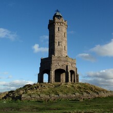
The West Pennine Way is a circular long distance walk which was devised by the Greenmount Village Community Hiking Group as a complement to the area and as a supplement to the Pennine Way. Passing many local landmarks but arriving there on sometimes unfrequented trails makes for a challenging route both navigationally and physically. It covers the area of the West Pennine Moors of Lancashire to the north of Bolton. The circular route passes Jumbles Reservoir near Bolton and visits Turton Tower, Cheetham Close, Dimple Hall, Delph Reservoir, Higher Critchley Fold, Longworth Clough Nature Reserve, Ornamental Reservoir, Winter Hill, Counting Hill, Smithills Moor Woodland Trust, Mass Trespass Memorial Stone, Roscows Tenement Clough, Two Lads, Rivington Pike, Rivington Gardens, Pigeon Tower, Rivington, Yarrow Reservoir, High Bullough Reservoir, Anglezarke Reservoir, White Coppice, Great Hill, Roddlesworth Information Centre, Darwen Tower, Darwen Moor, Bull Hill, Hoddlesden Moss, Clough Head, Ogden Reservoir, Musbury Heights, Burnt Hill, Alden Ratchers, Bull Hill, Pigeon Cross, Holcombe Moor, Harcles Hill, Peel Tower, Greenmount and Affetside Cross. 

GPS Track
Images