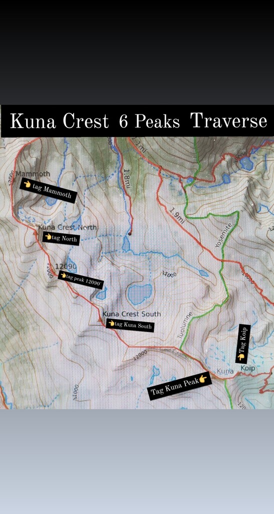
This is the FKT for the well-known “Kuna Crest Traverse”, tagging 6 named peaks from Mammoth to Koip, including one of Yosemite National Parks 13’ers, Kuna Peak, over the course of 18 miles. Enjoy this reason to get out into the lesser-visited eastern side of the Yosemite High Country.
The Kuna Crest Traverse has many forms listed on various blogs over the years but Mountain Project lists the Kuna Crest Traverse as an easy 5th class traverse, it describes two starts one from Tioga Road and another from Tuolumne Lodge. After mapping multiple variations, I think this loop from Mono Pass Trailhead is the most aesthetic (creating a clean loop) and environmentally friendly to the high alpine plant life (by utilizing an existing summit trail up or down from Koip Peak instead of bushwhacking).
Enjoy about 10.5 miles of trail and 7.5 miles of off-trail ridge traversing, ranging from “easy” class 2 all the way up to full-on 5th class at the crux “sawtooth” section between Kuna Crest South and Kuna Peak. (see beta on Mountain Project). One could consider this a little brother to the heinously epic 51 peak link-up known as Convoluted Bliss.
There are many high-points throughout the traverse but the “required” named peaks are as follows:
Other high-points are encouraged but not required.
Further reading:
Peaksforfreaks.com talks about the Mono Pass Trailhead start/finish for Kuna Peak which, standing at 13’002’, is one of the three 13’000 ft peaks within the Yosemite National Park boundary. This ridge link up is a great single day way to tag this prominent peak.
Here is a blog that notes easy bailout options from this route
And here is a video from the official Yosemite National Park Service Youtube channel about the amazing flora on these so called “Sky Islands”
Submitted by Jason Hardrath (Follow on IG or FB)
Comments
This looks fun! Is your time for this on the way? How's the smoke down there?
Time is on the way!
It was pretty smoky.
Ths looks so rad!
I was wondering how was the ridge between Kuna Peak and Kuna Crest South specifically the sawtooth section north of Kuna Peak. I am planning on spending a weekend bagging peaks around the area and the crest looked very fun...the sawtooth between Kuna Peak and Kuna Crest south looks like the crux. I could not find any solid beta on it. Any information or pictures would be greatly appreciated.
There is a gully between Kuna Peak and Kuna Crest South, before the Sawtooths. This is the most technical climbing section in my opinion, going at low 5th both downclimbing into the gully and climbing up out of it. It is dirty, has tons of loose rock, and is semi-exposed. As with the sawtooth section, the climbing itself is easy, its the rock quality that makes it sketchy. Take your time and test everything before trusting your weight to it. The sawtooths themselves are easier climbing, and if you don't summit the tooths, it stays 3rd/4th class if you contour on the right of them. Again, really bad rock quality, tons of loose stuff that looks solid until you step on it. It is exposed, and you would not want to blow it or have something pull out. That being said I had no problems just taking my time and being careful through this section.