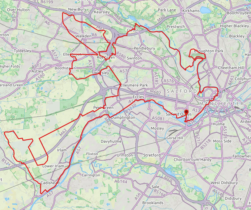
The Salford Trail is a new, long distance walk of about 50 miles/80 kilometres and entirely within the boundaries of the City of Salford. The route is varied, going through rural areas and green spaces, with a little road in between. Starting from the cityscape of Salford Quays, the Trail passes beside rivers and canals, through country parks, fields, woods and moss lands. It uses footpaths, tracks and disused railway lines known as ‘loop lines’. The Trail circles around to pass through Kersal, Agecroft, Walkden, Boothstown and Worsley before heading off to Chat Moss. The Trail returns to Salford Quays from the historic Barton swing bridge and aqueduct.
The Trail has been divided into sections, each accessible by public transport. There is a leaflet for each section describing the route and you can get a copy of each leaflet via visitsalford.info/thesalfordtrail

Comments
Hi how come this goes back to the start? the original route starts at Salford Quays and ends in Cadishead/Irlam 48miles
https://www.manchesterandsalfordramblers.org.uk/images/group/salfordT/T…
i am planning on setting a time on the original route soon
thanks
forgot to mention i will be starting in Cadishead to section 7 Worsley then doing the full loop back to Worsley
thanks
The website referenced in the route description clearly states: "The Trail returns to Salford Quays from the historic Barton swing bridge and aqueduct." The route is also so shown on the LDWA website: https://ldwa.org.uk/ldp/members/show_path.php?path_name=Salford+Trail
So, for the FKT you need to complete the full ~ 53 mile loop.
as you mention the route description states "The Trail returns to Salford Quays from the historic Barton swing bridge and aqueduct." this is referring to section 8 to section 1 not the end section 10 Cadishead to section 1, the LDWA isn't the official website for the trail, the route above from section 10 to section 1 isn't sign posted as the Salford Trail, I am not bothered its only a few miles but the above is not the official route section 1 to Section 10 the route is not a loop.
thanks
I put the route up originally and made it into a loop. Just run your own interpretation if it’s a problem. Or upload your version to the FKT website.