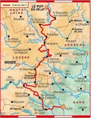
Location
France
Distance
276 km
Vertical Gain
7,460 m
Description
FKTs
Male
| David Fournel | 2d 19h 19m 33s |
| Grégory Savit | 3d 12h 25m 5s | ||||
| Nicolas Le Floch | 4d 10h 51m 35s |
Images
Comments
Pour se FKT il me semble que Sébastien Raichon (détenteur du FKT GR5) et Sandrine Beranger l'on fait en 47h15 environ l'année dernière
https://www.youtube.com/watch?v=rhqDNqClAPY
In 2021, some floods have destroyed the river banks of the Gardon River. In 2022, 2 options are possible to arrive at Saint-Jean-du-Gard: https://www.mongr.fr/trouver-prochaine-randonnee/itineraire/gr-70-le-ch…
a) via the correct GR70 down to the Gardon river and follow the national road D907 to the town. (the GPX of the FFR is incorrect as it still shows the GR70 that is currently impossible because of the floods of the Gardon, this is why the GR70 2022 provided on this site is the more accurate, safe and future proof to not change in thenear future,best to do the FKT records.
b) a deviation in the mountains that is apparently well marked. The Stevenson "dot org" association told me this deviation is a 3 year concession (permit) they have so it is probably not permanent.
So did they make this deviation ? Because the few kms of the D907 today is dangerous (cars) compared to the the part that follows the D907 inland, then crosses the river. Unfortunalety this "safer" original GR70 isn't possible anymore. So the most accurate GR70 today following the original GR70 is the one on this site. It is just above 276 km. The 271 km is based on a GPX of the GR70 that is incorrect because it this trace goes South when arriving in the village of Luc, while the correct GR70 is going North East then back South. In short the direct route from Luc to Laveyrune is NOT the GR70, it's a shortcut someone has probably taken, shared his/her GPX and most people are sharing and following the wrong GR70.
Conclusion: Use the GPX I made this july 2022, it has been validated by the association Chemin de Stevenson. It is the most accurate and future proof for FKT records and following the Stevenso GR70 at 99,5% compared to the 100% not possible anymore because the Gardon floods have destroyed the 0.5% of the paths.
Bonjour, je m’élance demain Mercredi 20 Août 2025 vers 8h pour la traversée du GR70 (Chemin de Stevenson).
Le temps de Sandrine Bérenger et Sébastien Raichon (46h45’ si je me fie à leur vidéo YouTube) me paraît très ambitieux!
Je prévois tout de même de partir en autonomie complète (unsupported) avec 48h de ravitaillement pour essayer d’approcher ce temps. En cas de difficulté, je m’arrêterai me ravitailler et je proposerai une validation en mode "self-supported" dans ce cas.
L’objectif est surtout pour moi de préparer la diagonale des fous 2025: Test de mon alimentation, gestion du sommeil, enchaînement de 2 nuits en course...
Je tenterai le Gr70 entre fin avril et mi mai 2026 en fonction des conditions météo et de praticabilité des sentiers. Par rapport à ces 2 variables aussi, je ne sais pas encore si je serai en en unsupported ou self-supported. Objectif: prendre du plaisir avant tout.
Bonjour à tous, Je prépare ma toute première aventure d’itinérance longue sur le Chemin de Stevenson pour la mi-juillet. Je n'ai pas d'ambition de record (FKT), mais je souhaite me dépasser et tenter l'aventure de ce tracé d'une seule traite.
J'ai remarqué qu'il y a un doublon de page sur le site. C'est d'ailleurs moi qui ai créé la seconde fiche ("GR® 70 : le chemin de Stevenson") en y téléversant la trace GPX me paraissant la plus récente à ce jour. https://fastestknowntime.com/route/grr-70-le-chemin-de-stevenson-france
Ma question pour la communauté et les administrateurs : pour mon aventure (et pour les futurs FKT), vaut-il mieux suivre la trace historique de cette page-ci (mise à jour 2022) ou la trace que j'ai partagée sur l'autre fiche ? Laquelle correspond le mieux à la réalité du terrain aujourd'hui ?
Merci d'avance pour vos retours et vos précieux conseils !
-----
Hello everyone, I am planning my very first long-distance multi-day adventure on the Stevenson Trail for mid-July. I do not have any record (FKT) ambitions, but I want to challenge myself and experience this beautiful route in one go.
I noticed there is a duplicate route page on the website. In fact, I created the second page ("GR® 70 : le chemin de Stevenson") myself, uploading the GPX track that seemed to me to be the most recent one to date.
My question for the community and the admins: for my adventure (and for future FKT attempts), is it better to follow the historical GPX track from this page (2022 update) or the track I uploaded on the other page? Which one is the most accurate regarding current trail conditions?
Thank you in advance for your feedback and advice on my first big challenge!
Bonjour à tous,
Suite à des recherches approfondies et en comparant le tracé officiel "MonGR" avec la trace GPS d'une de mes connaissances ayant parcouru le GR70 en mai dernier, j'ai enfin réussi à consolider une trace cohérente. J'espère qu'elle permettra d'éviter de trop chercher son chemin sur le terrain !
Il y aura malheureusement quelques légers écarts par rapport à la trace actuelle affichée sur cette page (en raison des récentes déviations et mises à jour de l'itinéraire officiel). Malgré ces petites différences, je publierai tout de même mon activité ici si j'arrive au bout de cette belle aventure.
Hâte de me lancer !
-----
Hello everyone,
After some extensive research and comparing the official "MonGR" route with a GPS track from an acquaintance who completed the GR70 this past May, I have finally managed to put together a consistent track. Hopefully, this will prevent too much route-finding guesswork on the trail!
Unfortunately, there will be a few slight discrepancies compared to the track currently shown on this page (due to recent reroutings and official updates of the trail). Despite these small differences, I will still post my activity here if I make it to the end of this great adventure.
Can't wait to start!
Bonjour, je vais m’élancer sur le Gr70 jeudi matin à 6h00 du matin. J’ai prévu ce qu’il faut en nutrition et préparé les points de ravitaillement en eau pour être en autonomie totale sur 60 heures environ. Il va faire chaud et comme c’est ma première aventure de ce type je ne sais pas si ma condition physique et mentale me permettra de tenir le rythme. En fonction de mon avancée et des aléas je serai donc en autonomie totale (unsupported) ou en semi-autonomie (self-supported), sans aide extérieure dans tous les cas. Objectif principal : aller au bout. J’espère revenir ici avec une trace complète Le puy en Velay -> Alès.
——-
Hello everyone,
I will be setting off on the GR70 this Thursday morning at 6:00 AM. I have carefully planned my nutrition and mapped out water refueling points to be unsupported for approximately 60 hours.
The weather is going to be hot, and since this is my very first adventure of this kind, I don't yet know how my physical and mental condition will handle the pace. Depending on my progress and any unexpected challenges, I will proceed either unsupported or self-supported with commercial stops (unsupported vs. self-supported), but without any outside assistance in either case.
My main objective is simply to reach the finish line. I hope to return here with a complete track from Le Puy-en-Velay to Alès."
Regional Editor's note: Nicolas Le Floch diverted from the route two or three times. However, given the long distance of this trail and the minor mistakes, it's been accepted.
merci Carlo d’avoir accepté d’enregistrer mon FKT malgré mes erreurs de parcours.
Je voulais signaler qu’entre la corniche des Cévennes et Saint-Jean du Gard, juste après avoir quitté la route en prenant le chemin qui monte vers la gauche, au bout de 200m environ, le balisage (qui disait d’aller à droite) était différent de ce que m’indiquait la trace GPX (qui disait d’aller tout droit) pour rejoindre St Jean du Gard..
De nombreux autres randonneurs, qui, suivaient également le chemin de Stevenson ont également remarqué cette différence de tracé.