
Boundary Waters Traverse
(my tracking and gpx methodology and explanation is at the end)
This run was almost 3 years in the planning. The Boundary Waters Traverse is the joining of two established trails: The Border Route Trail (“BRT”) and the Kekekabic Trail (“the Kek”) which are both point to point trails that meet roughly a quarter mile apart in the middle of the Boundary Waters. This is an awareness and advocacy project to highlight the threat the Boundary Waters Canoe Area Wilderness faces from sulfide-ore copper mining. I conceived of this project as a way to bring awareness of this issue to runners and specifically trail runners across the United States and potentially the world if anyone out there is watching.
The Boundary Waters is 1.1 million acres of pristine boreal forest in northeastern Minnesota. It is home to over 1,100 lakes which are all interconnected by rivers, streams, marshes, bogs and wetlands. The Boundary Waters is home to iconic species such as the Canada Lynx, Moose, Grey Wolf, Beavers, Black Bears, Loons and other migratory birds. The Boundary Waters is the top of the watershed where all rain and snow melt flows from the Boundary Waters through the border lakes region into Canada and Voyageurs National Park. All this water eventually flows into the Atlantic via Hudson Bay.
The Boundary Waters is typically traversed via canoe with portages over land linking lakes or running alongside rivers or streams. This is a world class water based wilderness and a destination for paddlers, hunters and anglers, girl and boy scouts, church camps and is a multi-generational family legacy Wilderness.
There are also over 250 miles of hiking routes traditionally used as backpacking camping routes, all of which I have now run.
The Boundary Waters is under threat from a proposed massive sulfide-ore copper mine that, if built, would generate acid mine drainage in the form of sulfuric acid and flow straight through the heart of the Wilderness and also into Canada’s Quetico Provincial Park and Voyageurs National Park. The mine site and waste rock tailings would perpetually pollute turning this world class wilderness and pristine watershed into a polluted chain of lakes, rivers, streams and marshes forever.
I have been running through “canoe country” for the past 2 years to bring awareness of this threat to runners and trail runners. I hope if you are reading this you will head to www.savetheboundarywaters.org to sign our petition asking for permanent protections for this Wilderness and the pristine water it houses. As of May 2021, we have a bill in the U.S. Congress, are fighting several lawsuits and have a piece of legislation in the Minnesota state legislature. Please do what you can to protect this water and this Wilderness. You can also read about all my Boundary Waters running on my personal Running for the Boundary Waters website and blog
Now about the run:
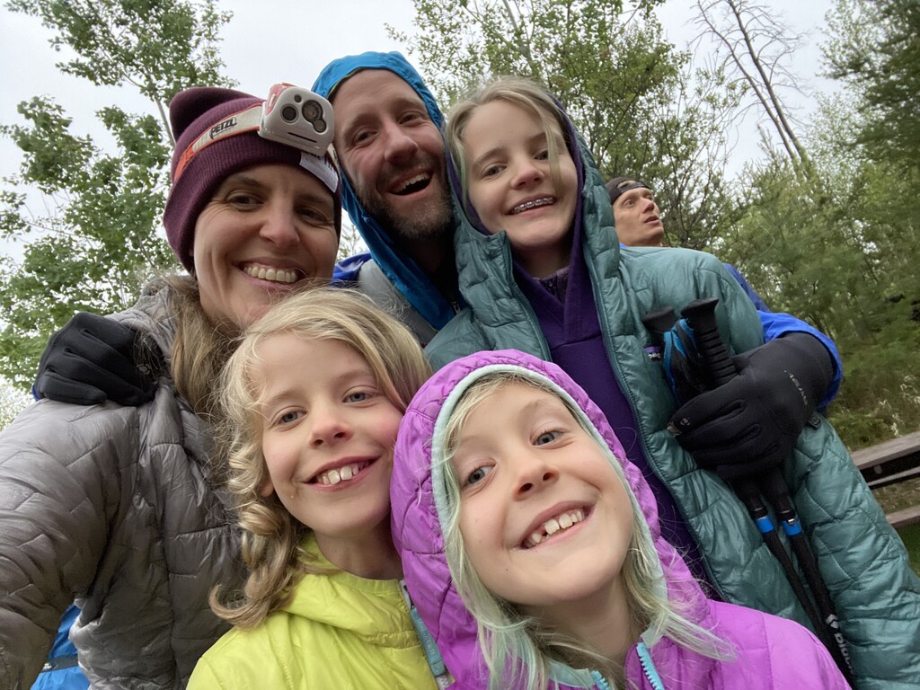
This run was a passion project supported by friends, family and a couple world class elite trail runners. Patagonia sponsored runners Clare Gallagher and Peyton Thomas and Altra sponsored runner Kyle Pietari all joined for various segments as my crew and pacers for this run. Brendan Davis, professional trail running photographer, ran roughly 45 miles with me and was at the couple aid stations accessible by roads. Also joining me were Grand Marais, MN Mayor Jay Arrowsmith-Decoux and a friend and manager of the Running Store in St. Paul and Minneapolis, Matt Wardhaugh.
I was supported throughout the run by “paddle-in aid stations” by family, friends and coworkers. Those deserving credit for upending their lives in support of this run are: Erica Falconer, my wife and crew chief; our kids, Elsie, Donnie and Eddie; Save the Boundary Waters Campaign staff and friends Ingrid Lyons, Megan Wind, Levi Lexvold and Cassandra Prenn-Visilakis; Piragis Northwoods outfitting guide Tim Barton; WTIP Boundary Waters Podcast Host Lindsey Gau and her friend Maggie Friedrichs, and Erica’s parents Rob and Mary Welch.
These aid stations were crucial given the temperature swings (80’s and super humid during the day, 40’s and raining overnight) for gear changes as well as real food and a quick sleep station.
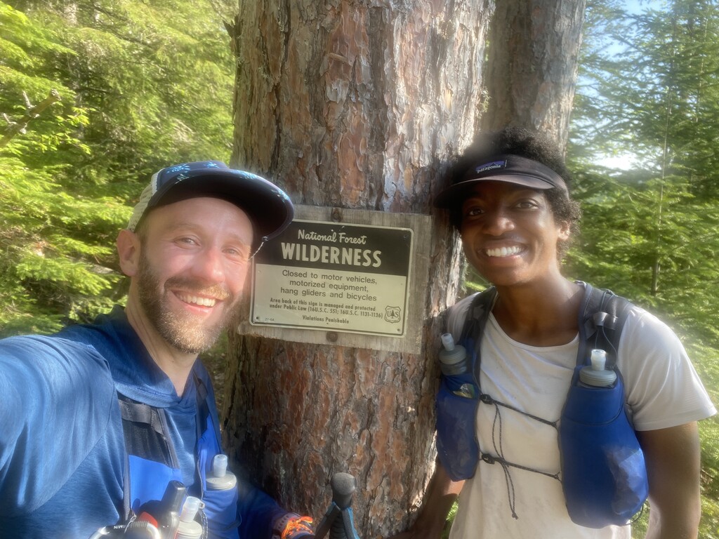
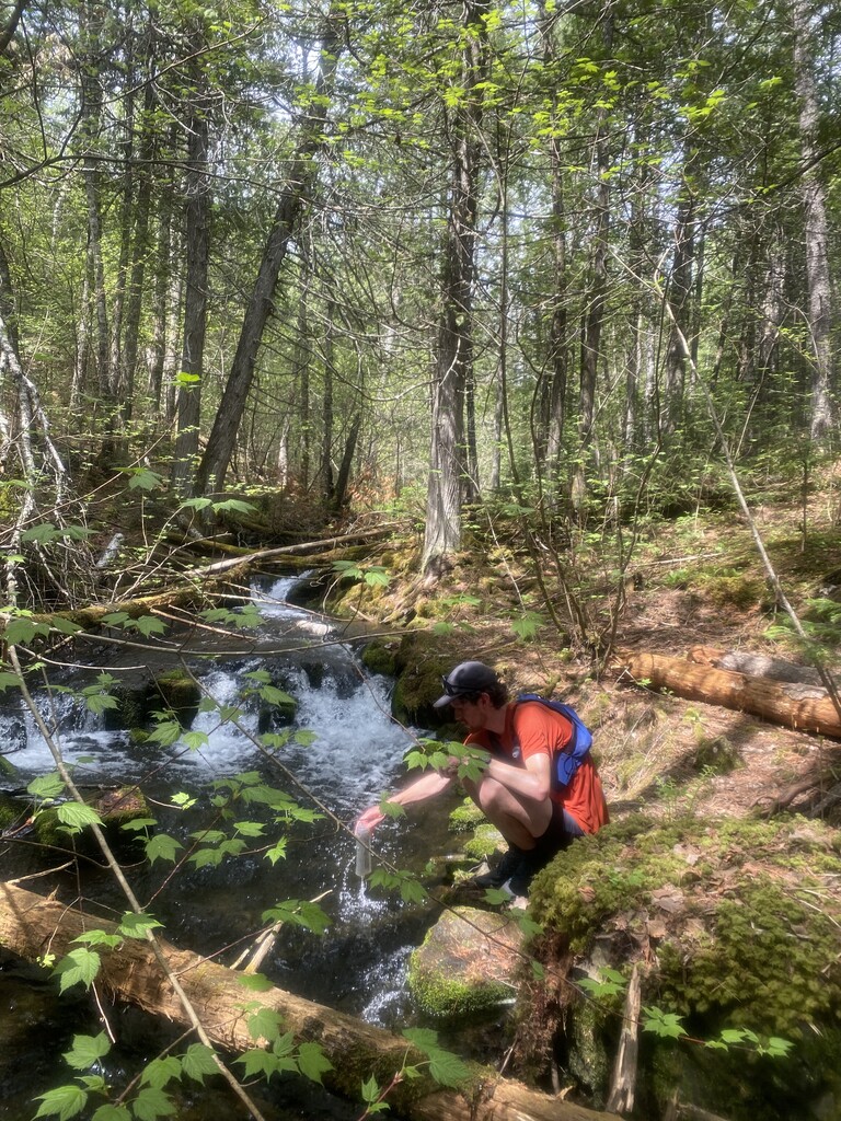
This run could potentially be done unsupported, though I would not recommend it (someone out there just said “challenge accepted,” I’m sure). The terrain is roughly 18,000 feet of elevation gain; is rocky, muddy, rooty, marshy, swampy and crosses beaver dams, rivers via fallen log or boulders, and is a constant grind and death by a thousand cuts of consistent up and down - many times almost vertically climbing up and down granite boulders and cliffs or switch backs up the side of palisades. It will take longer than you’d expect for a 110 mile route for any experienced trail runner. Roughly 90 of the 110 miles are all also remote Wilderness with no way out except the other side. Eyes wide open - you cannot be quickly extracted if something were to go wrong. I carried along with me a Garmin inReach for communications and in case of emergency, an emergency foil blanket, small first aid kit, ace bandage and water proof matches. Food and water were replenished at aid stations and additional water was sourced from the lakes and streams along the route - sometimes filtered, many times not (remember - pure and pristine!).
Runners and some of our crew camped overnight at the McFarland Lake campground the night before. I was delighted to learn the BRT Association was also there camped out in the middle of a spring trail maintenance trip. They really are heroes of these trails working diligently year in and year out keeping the trails open and accessible to everyone. I cannot thank them enough and look forward to joining them on future trail clearing projects.
During the first segment from the BRT East Trailhead, I was joined by Grand Marais Mayor, Jay Arrowsmith-Decoux. His energy and quick witted sense of humor was the perfect beginning to the start of the run at 4:18 am. The sky was just starting to lighten as it was pre-dawn when we hit the trail with Erica, the kids, Clare and Brendan there to send us off. The 12 miles passed quickly on fairly heavily trafficked trails that were easy to follow and traverse. My legs were also fresh and we were cooking along and met the crew at our first aid station at the McFarland campground.
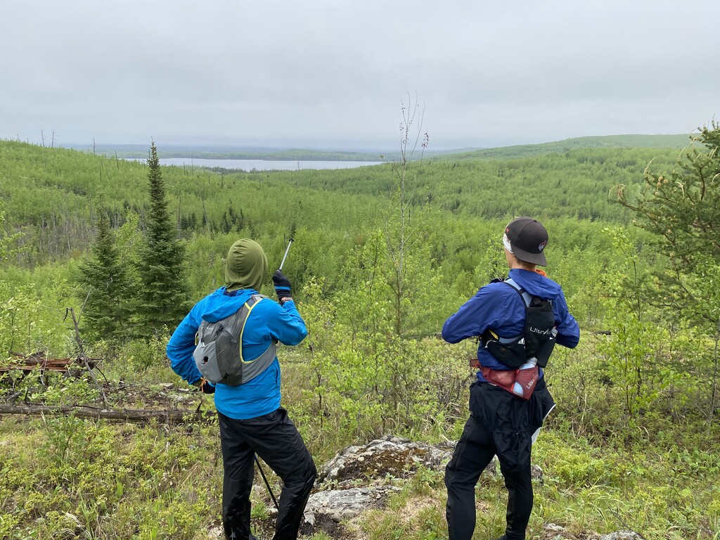
Socks were changed, food consumed, supplies refilled. We said goodbye and thanks to Jay and welcomed Peyton and Brendan for the next segment. It was just past 7 am when we left and in the full light of day for the segment from McFarland to Clearwater Lake where our first paddle in aid station would be ready for us. The weather quickly turned hot and slowed our pace a bit. It’s a 1 mile climb to the Wilderness border and the next 15 miles from McFarland to Clearwater are mostly a consistent climb and descent running above the Pine and West Pike Lakes. When we got to Gogebic Lake, we were pleasantly surprised that the water wasn’t flooding the trail and we could actually walk along the beaver dam and stay on the trail. The previous two times it’s been flooded out and I’ve had to bushwhack around the flood. This saved us some time. By now we were getting pretty hot so we stopped at Gogebic’s shore, doused our hats in the water to cool off, watched a canoe with some people trying to catch dinner for a bit and moved on. The river running between Clearwater and West Pike flows strong and has good water, so we stopped and filled our water - first time on this segment - even though it was a short jog to the Clearwater aid station. Erica and the kids, Clare, and Lindsey and Maggie from WTIP met us there for a short refuel and sock change stop. Peyton stayed and headed back with Erica and the kids and Clare, Brendan and I took on the next two segments of the BRT.
The weather continued to be hot as we ran/jogged/hiked up and down the palisades. We were moving at a decent pace, stopping for some food and drink as we could. My stomach had started to reject most things and I was on mostly scratch powder and candies. At some point Clare forced a Gu on me - a cherry chocolate that I promised would come right back up - but to my surprise it went down, stayed down and was a source of energy! My road marathon days had taught my system to reject the pasty gu’s so I was really surprised it worked out. The flat section along the river leading to Rose was a treat. Clare and I took the opportunity to speed up and banked some time. Brendan’s legs were starting to cramp up so he kept at a steady pace just behind us. When we got to Rose I stopped and threw my tribute rocks for Donnie, and the three of us ran along Rose just until the campsite leading to the big climb up the palisade. We met some hikers/campers I handed some Save the BWCA stickers out to, and we made the climb. Brendan cramped up super bad almost at the top and had to stop and rest it out. Clare hung back with him a bit, I continued on to the Rose Lake aid station near the falls and sent Cassandra back with trekking poles when I arrived. Brendan’s leg relaxed and he bounced back and he and Clare weren’t too far behind. Megan, Ingrid and Cassandra had everything prepped and ready, it was the perfect stop. Backpackers Pantry Pad Thai, Patagonia provisions soup, mashed potatoes, new candy and more fueled us up. Right as we were packing up to leave the rain started and we’d be wet for the next 6 hours…
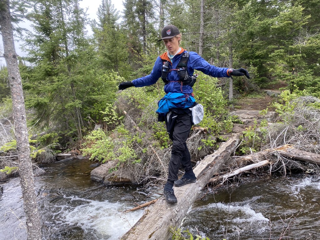
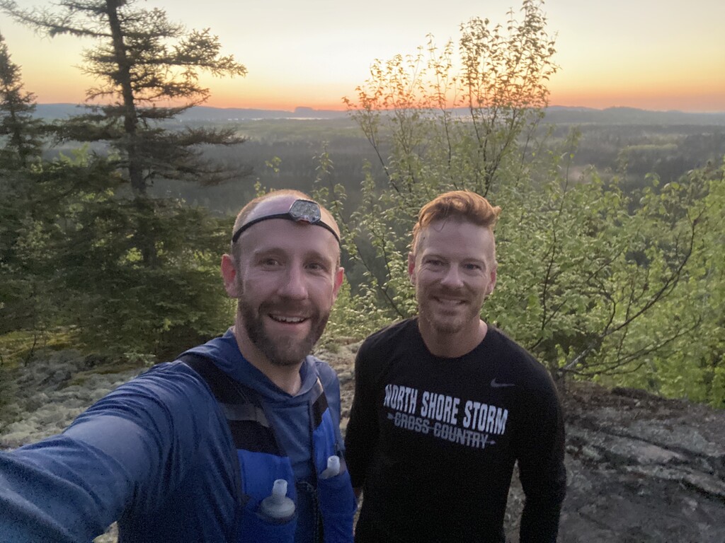
As we set off, thunder broke out, the temp dropped from 80 to 43 and the sky opened up into a downpour for about 20 minutes, though it might as well have been the rest of the night. The leaves were soaked and showered us for the rest of the journey to Loon Lake Road. To say we were cold and miserable was an understatement. Thankfully we all had a waterproof rain shell and gloves so we just plodded on. Headlamps were deployed when we hit the river at Mucker Lake as we crawled across a log over the river and continued on. At this point it was really more about getting out of the cold and wet - it had stopped raining but it didn’t really matter, the trees and leaves kept reminding us of the rain and didn’t let up on the soaking. A wrong turn toward Crab lake, and a depressed run back to the trail and we continued on finally meeting Erica and the crew around 1 am. I got into the hot warm car and changed into dryer/warmer clothes and soaked up the warmth longer than I wanted to but definitely necessary. The kids were in the back barely awake but it was good to see them even for a bit as I ate, drank some warm, salty veggie broth and got over my shivering attack. I didn’t know at the time, but this is where my watch decided to restart for no good reason, but I was warmed up, changed and Peyton and I hit the trail for the last 10-11 miles of the BRT.
That part of the trail is my least favorite of the entire Traverse - and worse so in the dark. Private ATV, ski and snowshoe trails criss-cross the BRT every so often making us stop and check the map frequently. BRT flags cut differently than the map might indicate, but we followed the trail crew signage, met Erica, Clare and Brendan along the road a couple times and kept going. We never actually saw magnetic rock itself - hidden in the shroud of the dark misty night and that last 3 miles seemed to loop and meander around forever, though our pace picked up with the adrenaline kicking in for finishing the BRT section at last.
Around 4 am we ran into the aid station set up by Erica’s parents at the BRT West parking lot with a screen tent, warm pancakes and hot soup. I had been planning on resting a bit so climbed into the car and laid down for a 10 minute nap. My stomach was also on the verge of rejecting food so hoped to settle it down. Erica came in, got me up and sat me down near the tent. Kyle and Matt were prepped and ready, they were swapping out for Peyton. Kyle pushed gf bread on me hard and it took me probably 10 minutes to get it down but the effort was worth it and felt like that really turned the tide for my stomach issues. “Here comes the Choo Choo train” will be a phrase with a new meaning for the rest of my life!
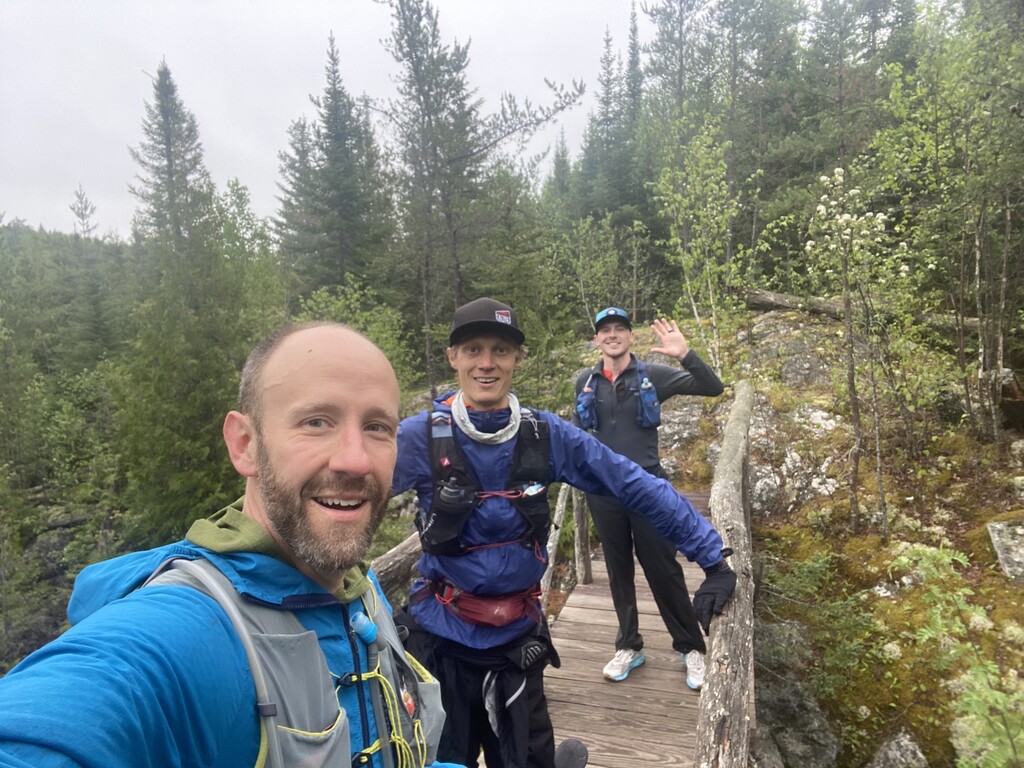
Kyle, Matt and I headed out down the gunflint to the Kek trailhead and sailed right on through to the beginning of the trail. The rest and food I was able to get into my system was a huge boost to my abilities and we set off down the trail with a new spring in my step. The sun had since risen as well and it was invigorating to have daylight again after a long and potentially dangerous cold, wet night.
The Kek is significantly flatter than the BRT but my worry was with the rain last night and couple days previous it would be overly muddy and really be a slog to get through. However that worry was not realized, it has been a very dry spring after all and the water levels didn’t affect us much.
Kyle and Matt did a great job keeping my brain awake and alert, with Kyle sharing his battle stories from WSER, Leadville and others and he and Matt pushing food and water on me consistently. When we hit the Agamok bridge (where thankfully Kyle didn’t plummet into the river…) and the long steady climb after, I was still moving pretty well - running when I could, hiking when I couldn’t. The descent down to the Kek Lake area brought us into the Kek-Strup lake aid station set up by Levi and Tim who had camped overnight and were ready for us to come by. A round of Pad Thai, provisions, potatoes and more - served on top of an overturned canoe no less! - and we were reinvigorated and headed out with fresh socks and new energy.
The next 12 miles were the flattest of the entire trip and the pace picked up with consistent gel and food stops. Mile 30 was a celebratory coke and potato chip food and drink stop - Matt was glad not to have to carry that any longer! Around Mile 35 of the Kek as the trail starts to go around Disappointment lake, the terrain became rockier - the Boundary Waters Traverse had 5 more miles of a goodbye present for us. Several hill climbs slowing us down - but thankfully because of car issues, Erica and the kids were delayed past the comfort zone getting to the end. The Kek wanted to slow us down so they could make it, it seemed and I was willing to just take the trail for what it was and go at the pace I was able and happy it would help them get to the end for the finish.
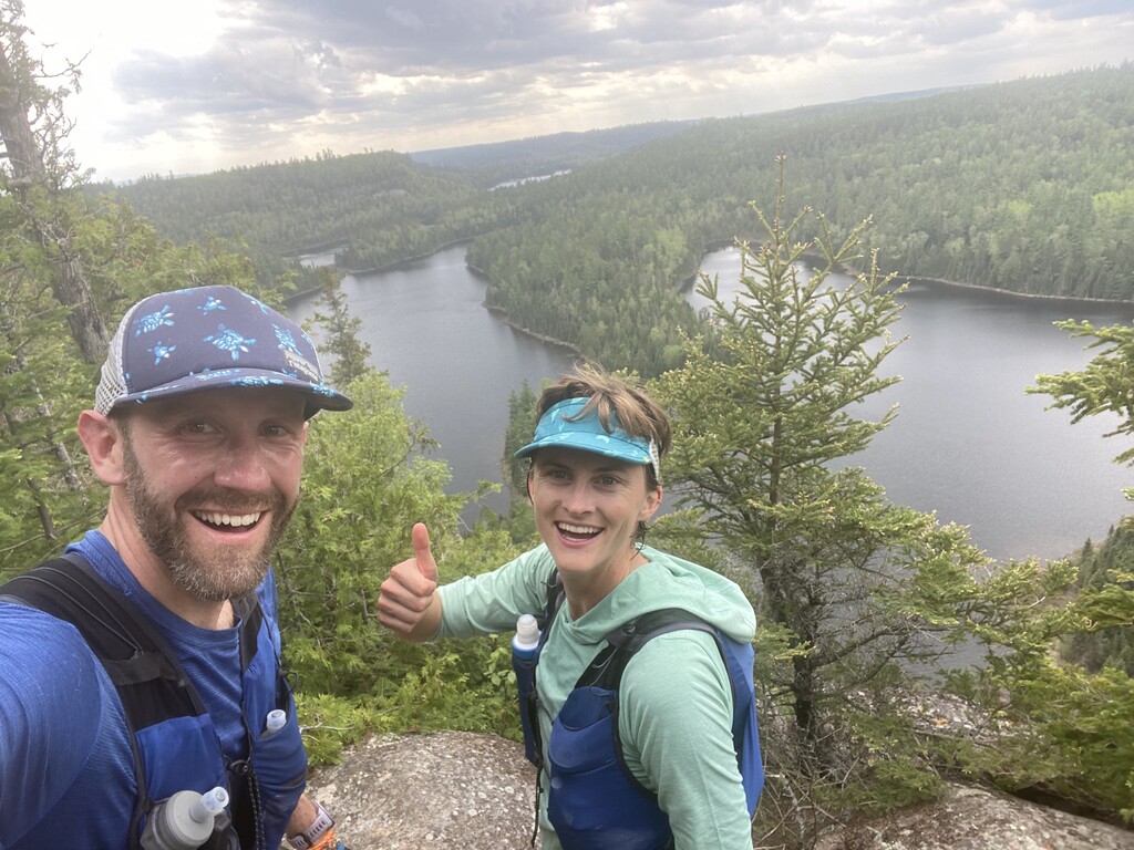
About a half mile out Brendan, Clare and Peyton met the three of us for a celebratory - you’re going to finish moment. A quick selfie by the Kek peace sign and we moved on. Erica and the kids discovered us a quarter mile later to cheers, tears and hugs and they did their traditional “bring daddy home” and jogged with me on the way to the ending.
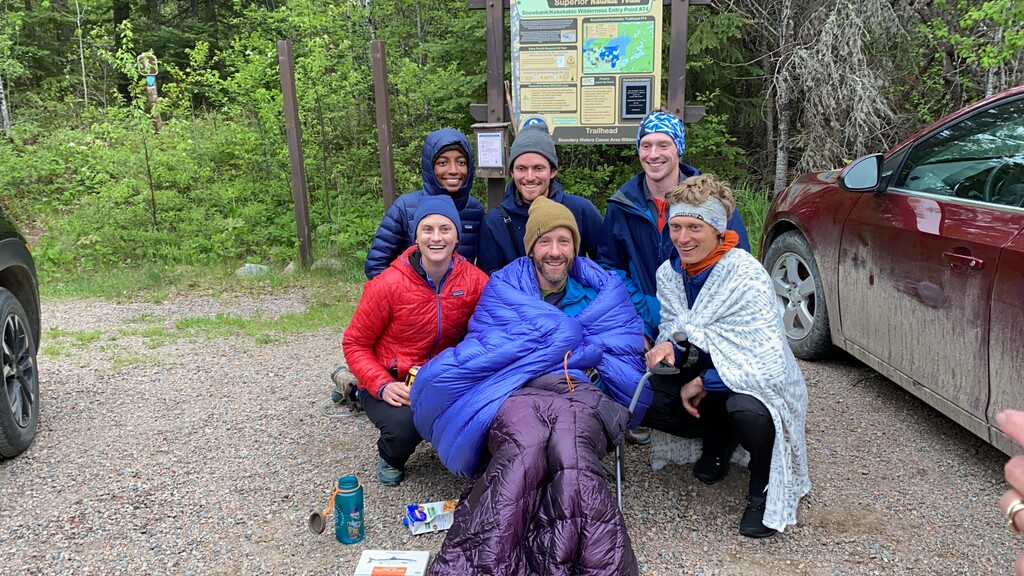
The end is really a blur, Becky Rom, the chair of the Campaign to Save the Boundary Waters was there with her husband Reid Carron and fellow board member Steve Snyder. Erica’s parents, Mary and Rob, and Megan, who made it all the way from the Rose Lake aid station along with the runners, Erica and the kids were my welcome home party. I ran past the crowd to tap out at the trailhead sign, stopped my watch to cheers and we celebrated the finish with me sitting in a chair wrapped in sleeping bags, blankets and food and drink as I was able to take it down and watched in a daze as everyone came together again at the end.
Final time (as explained below) was 38 hours, 15 minutes and 3 seconds for the first known Boundary Waters Traverse via trail run.
I could not have finished as well as I did without the consistent love and support from Erica. She was the solid rock behind the entire run and the planning and prep leading up to it. She helped calm my nerves and anxiety leading up to it, pushed me out the door for 5 am training runs when I didn’t want to, and was there the entire journey with food, drinks and love. The kiddos were troopers putting up with consistently being woken up in the middle of the night, sleeping in the car and putting on their happy faces for me as I came in.
Clare has been a constant source of inspiration and support from the very beginning. I first pitched the idea to her as a cold walk up introduction after a panel she was hosting at the Outdoor Retailer show in Denver early in 2019. From the get go she got Patagonia on board for support, helped publicize and kept me motivated to finish this thing out more than she probably knows. And during the run her stoke level of enthusiasm and fun conversation kept us moving along through the heat and even the cold rain.
This was Brendan’s 2nd trip to the Border Route Trail run with me to photograph the journey. His pictures have so incredibly captured the experience and I can’t wait for him to get to share them with the world. He’s also just such a kind hearted, supportive, low key guy who also happens to be an incredibly professional trail running photographer. It is no small feat to run 45 miles carrying 3 cameras and snapping 3000 pics along the way.
Kyle came in clutch at the Kek pushing food on me to get over my GI issues and kept a steady stream of energy going both in fuel and mental/emotional support and the occasional inappropriate joke. “You’re in a good position to finish” will always ring in my head in his voice toward the end of ultras.
Matt alongside Kyle kept the air light, conversation flowing and stayed with me while Kyle took care of filtering and replenishing our water stock. I’ve only met Matt recently and we’ve now run together for more miles than I’ve shared with anyone else outside Kyle and Brendan and I can’t thank him enough for taking the leap and joining the trip.
Peyton filled in during crucial moments during the heat and the opposite after the cold and wet and pushed me through the worst running conditions and emotional dead zones I had. She’s a brilliant scientist and Ph.D student who kept my mind on shark musculature and laboratory experience vs the pain and exhaustion. I’m a science nerd and that was really a fantastic mental boost to have those conversations!
Jay was a great start and boost of energy from the start, setting the tone for an amazing run right from the beginning. Thank you so much for getting up earlier than you anticipated to kick off this crazy journey.
And of course the aid station captains coming in clutch. Thank you so much Lindsey, Maggie, Ingrid, Megan, Cassandra, Levi, Tim, Mary and Rob. The food, drink, happy conversation, and supportive pushes out the stations helped more than you’ll know.
GPX data and timing explanation:
I ran the first ever full Boundary Waters Traverse on May 22nd through May 23rd. Please note, my gpx files and data are pieced together, my Garmin watch restarted around mile 56 and I lost some data. The main source points are my starting time at the eastern Border Route Trailhead at 04:18:10 am on May 22nd and my finishing segment of the Kekekabic Trail and the Kek Trail Head west ending at 18:33:13. Total elapsed time is 38 hours 15 minutes and 3 seconds. I also included the gpx file from my Garmin Inreach that was on the entire route, however, was tracking before the run started and tracking after the run ended. It does show the entire route as a gpx file, though given the pin drops every 2 minutes, shows less miles vs the full 110 due to loss of trail in the point to point line it drops. A pic before stopping tracking shows 108 miles on trail and 38 hours 18 minutes and 37 seconds Trip Time due to the tracking starting before and after the actual run. I am submitting the time based off my watch’s incomplete data though it did accurately start and finish the run, however if the Inreach is the only acceptable proof so be it. I’ll let the experts decide.