

Start location: Cairn at Point Lookout (1,562m) at 6:47am
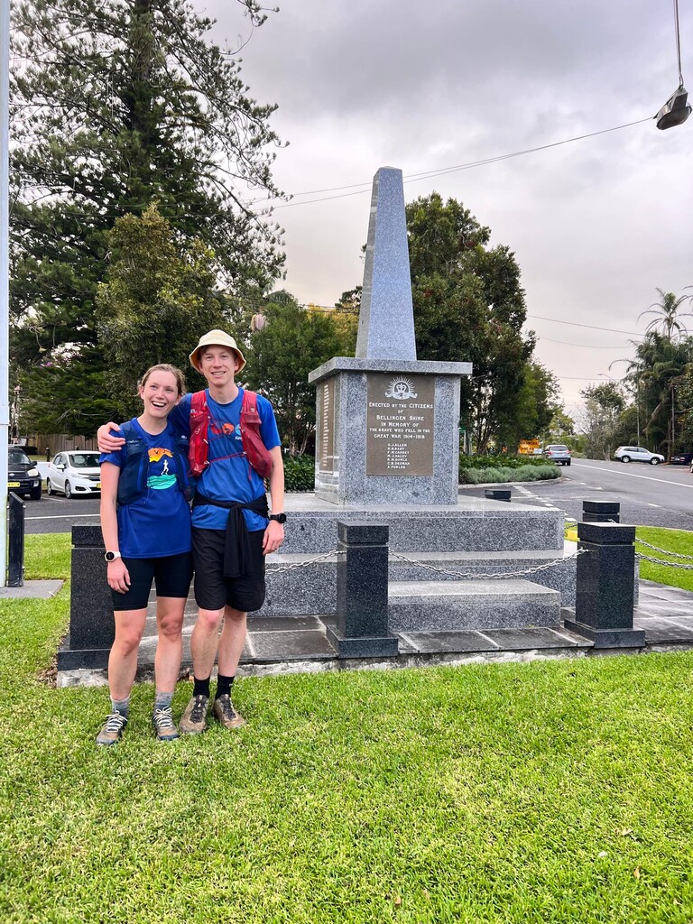
Finish location: Bellingen War Memorial (22m) at 4:18:53pm
We camped the night before at Thungutti Campground at Point Lookout. The temperature was 7c when we arrived at 5:00pm, a bit colder at the top lookout of which there were little views, but the temperature stayed the same throughout the night and morning.
We walked out to the lookout in the morning again but there were no views. It was very foggy. Usually, the views are amazing with an expansive outlook over wilderness. We left our car at the top carpark and we are very grateful for Sam and Peter Birch for picking this up for us and bringing it back to Bellingen. Thankyou!
On Saturday 22.04.2023, we left the Cairn at Point Lookout (1,562m) at 6:47am and ran down Point Lookout Road to where it meets Robinsons Knob Trail. The temperature was 7c, cool but not cold and once we reached the Robinsons Knob Trail junction, Annabelle took 1 minute to take off a long sleeve top, gloves and buffs. It was going to be shirt weather for the rest of the day!
As we turned onto Robinsons Knob Trail, National Parks have done great work upgrading the trail surface out to Wrights Lookout. At the 4.5km mark, Robinsons Knob Trail changes and now become a wide leafy management trail. We were also following the New England Wilderness Walk here. The Robinsons Knob Trail follows a ridgeline down on what is known as the Snowy Range.
The trees feel ancient here. And that's because they are. The Antarctic beech rainforests found here are remnants of when Australia was connected to Antarctica on the supercontinent Gondwana. The park has been protected since New England National Park was established in 1931 and it is part of the World Heritage listed Gondwana Rainforests of Australia. We were now also in the New England Wilderness Area - an area covering 51,700 hectares where the native plant and animal communities are essentially unchanged by human activity. We were running through special Country.
Robinsons Knob Trail is beautiful to run down, with filtered views out over the wilderness. There were some small fallen trees on the trail but we could run over them easily. At 10km, we reach a fork in the trail. There is a very old sign, put here by the former Bush Fire Committee.
The left fork follows Grasstree Trail along the New England Wilderness Walk that eventually follows the Bellinger River and finishes at the end of Darkwood Road. Down this left fork is a large antimony deposit which was mined in 1907 and was accessed from Point Lookout by army trucks to remove the mined ore. We will have to do Grasstree Trail another time.
We took the right fork, continuing along Robinsons Knob Trail for another 7.5km. This section was the most challenging of the day. The trail becomes steeper with short uphills. There is more debris down on the trail here, some requiring clambering over.
There is a sign on a tree that tells us we are now on Tiger Cat Spur. I had not seen this sign before, because i had only done this track in reverse. That was when I ran with Konrad Legge and Andrew Mcdonald from Bellingen to Point Lookout on 28 July 2018. https://www.strava.com/activities/1732404353. It was exciting doing it in reverse.
This 7.5km section of the trail has also changed a lot since I did it 5 years ago. There was up and downs that I don't remember and the trail quality was worse. Knee-high farmers friends and weeds were sprouting up more regularly around the 15km which was unfortunate to see. Small sections felt snakey but we didn't see any snakes all day. I felt like noone had been in this bit for a long time. It was remote and wild.
Annie said this section felt hard and I agreed. Despite the amount of downhill we had run, there was a lot of uphill in this bit. I brushed half of my right forearm against a stinging nettle in my attempt to dodge farmer friends and it stung. I remember thinking that unless National Parks clear the weeds and fallen trees, this would be my last time in this section. The surroundings were still beautiful with amazing filtered views but the poor track conditions were frustrating. I hope this changes as it would not be difficult to slash. It was about 3km of ordinary trail all up - pretty good in a 70km remote run!
That all changed when we reached a locked management gate just before Comara Trail. National Parks had cleared and maintained the next 13km of trail from Comara Trail junction back to Bellbucca Rd / Horseshoe Rd junction. It was fantastic to run on and I really hope they continue past the locked management gate and remove some of the weeds.
At 18.5km we turned onto Kilprotray Road. This is a stunning road with glimpses of the wilderness to the left and then to the right. We also noticed the vegetation had changed after all the descending. It was classic Koala country. And while I was regularly looking in the trees and for scratch marks I didn't see any. There was lots of beautiful parrots and lyrebirds though. Kilprotray Road separates New England National Park to the north and Gumbaynggirr National Park to the south. It was my favourite section of the day.
At 25km 3.5hrs in we reached Horseshoe Road. We would be following this amazing road for the next 30km. The terrain was great for running here and we were feeling good.
The land management of the forests changes a lot along Horseshoe Road passing through New England National Park, Gumbaynggir National Park, Oakes State Forest, Baalijin Nature Reserve, Roses State Forest and Scotchmans State Forest. But the vegetation and terrain feels the same throughout. I still haven't worked out the distinct differences and I suspect there aren't any.
We pass the walking track up Mt Killiekrankie - an dolerite dyk and a remnant of the Ebor volcano. We are at the headwaters of the Nambucca and Kalang Rivers here. There are magnificent views at the top of Mt Killiekrankie overlooking wilderness in either direction. It is worth the trip up Horseshoe Road and is easily driveable in a AWD.
We continue along Horseshoe Road, soaking in the filtered views of wilderness and enjoying many long downhills. At 32km, we reach the Zeepaert Trail junction which is one of the access points to the Bellinger River. Adrian Herron surprised us here. Adrian has extensive experience these valleys and recently spent 10 days explore the Bellinger River with his daughter. We would only see 2 x 2 groups of motorbikes on the entire run besides this chat.
The next 5km were a relatively sustained climb but the beauty of Horseshoe Road is that none of the climbs are steep. It just undulates along a seemingly never ending ridgeline. We could run the hills, but we opted to walk. Annie had been pacing it really well. It started sprinkling rain very lightly. The temperature would max out at 20c today.
We reached our first drop bag at the Orama Road junction at 44km 6hrs in. We placed this yesterday when we drove up Horseshoe Road and down Orama Road to Darkwood Road. This doubled as a trip to check out the end of the New England Wilderness Walk which unfortunately is in poor condition. For a premier walk, you would think it might be maintained better.
We had carried 2.5L of water each to this point and refilled with 1.5L each. I had a brilliant idea of stashing a 5L cast (goon sack-like) of water, using what we needed, pouring out the excess and then stuffing it in my running pack after. It worked really well and saved us having to drive back here to collect a water container. The food I placed in a dry bag so we were able to carry everything we placed out with us.
We continued on Horseshoe Road, enjoying the long downhills, walking the ups and maintaining a consistent pace. Without issue, we reached our next drop bag at 56km 7.5hrs where I had placed an identical stash of food and water. From here, we now turned off Horseshoe Road onto Hospital Range Road. We would follow this trail 15km all the way back to Bellingen.
It was mostly downhill from this point on along Hospital Range Road. The trail is more narrow with lantana intruding but is in good condition thanks to motorbikes. The ridgeline is beautiful and is easily accessible from Bellingen When the trail hits a junction with Short Cut Trail, it now becomes Scotchmans Range Road.
The last 15km section took us about 2hrs and we were running the same pace as when we started. Annie had paced it really well. We hit the bitumen and saw our first house of the day at 70km. It was only 1.5km back to the centre of Bellingen and we finished at the Bellingen War Memorial at 4:18:53pm where Adrian and Rainee Herron met us - with cheers and cowbells. We were slightly ahead of what we thought we might do and happy to finish in daylight.
Nutrition: Carried from start to 6hrs - 2.5L Trail Brew, baby food, gels (Annie only) and museli bars (Keelan only). Then at the two drop bags we picked up more baby food, roasted potatoes, salt and vinegar chips x2, vanilla coke x2 and only had water from 6hrs on. Also carried, EPIRB, Garmin Inreach and 2 x tension snake bandages.
Shoes: On Cloudsurfers with Creepers toe socks (Keelan), Topo Pursuit with Injinji toe socks (Annie).
Apologies for not taking more photos on course, as we were saving phone battery in case of an emergency. It was a fantastic day out in remote and wild country. The road network is excellent, quite accesible and yet rarely visited.
I would love to see/help more people explore this area or even attempt the FKT.