Inspired by the classic routes in the UK like the Bob Graham Round, (and others ) this route has evolved in the last years to this version today. Home to Acadia National Park we first did the Acadia Peaks Traverse in 2020 where we hit all 42 peaks on the island covering 65+ miles and 18,000+ feet of gain taking a bit over 24 hours. This route was attempted again by Jason & Michael with the OutsideTV show "Beat Monday" in 2022. You can view that experience here which gives a great visual of what the trails of Acadia (and the Acadia Round) are like. https://www.outsidetv.com/show/detail/Beat+Monday/play/QWFARCES/1/100/6Q0mpLni/4
In 2021 we made a 2nd attempt with less of the bushwhacking segments and to clean up the route a bit to make it one day easier for a visitor to complete the loop without major navigation challenges. We were around the 45 mile mark and cut it shorter than planned and that route we did use.
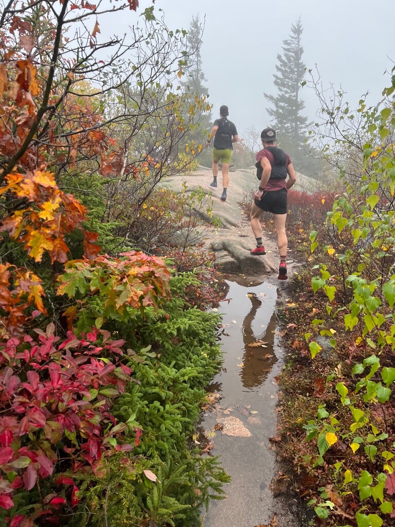
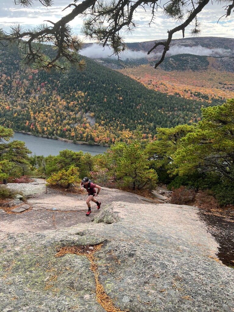
On October 15th, 2022 we set off on a new route that would cover these peaks: Champlain, Beehive, Gorham, Day, Triad, Cedar Swamp, Norumbega, Bald, Parkman, Gilmore, Sargent, Penobscot, Pemetic, Cadillac, Dorr, & Kebo. Sixteen in total.
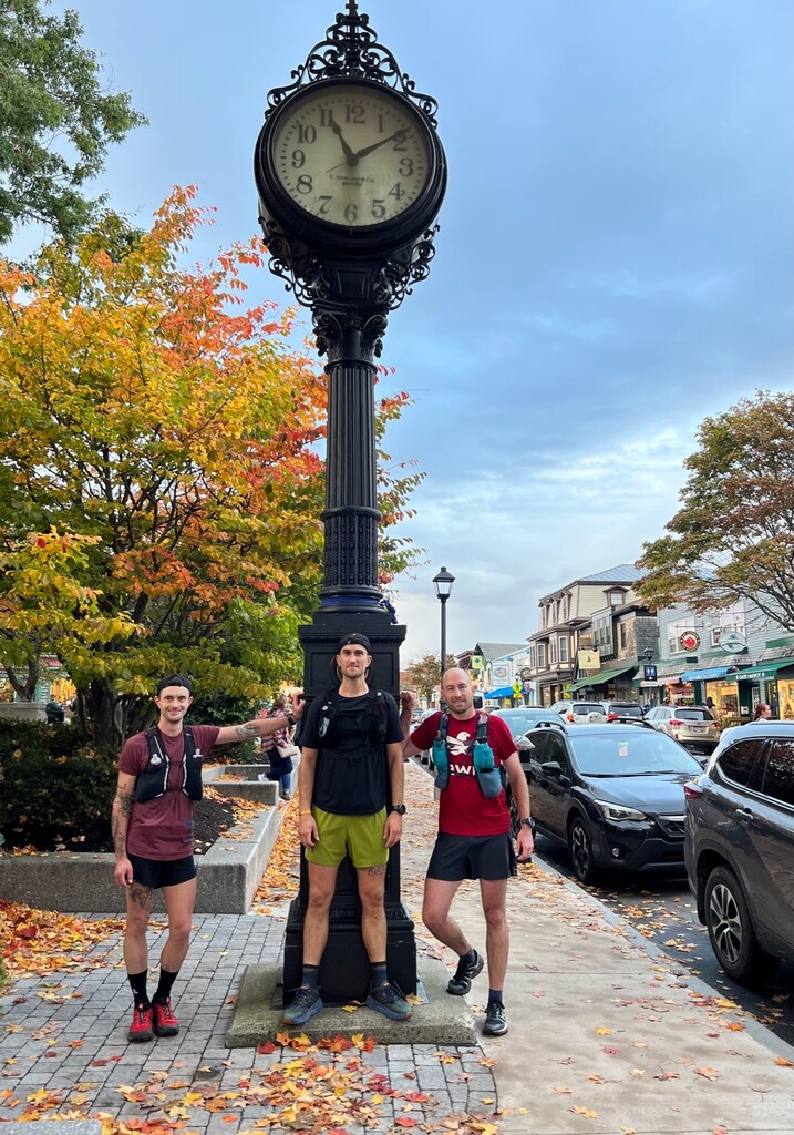
This route was designed to hit all the main peaks on the eastern side of Acadia National Park (removes a kayak crossing and tidal challenges for a full island crossing) and completes a full loop back into town. We start at the classic old clock tower in the Village Green of Bar Harbor. This is right next to Leary's Landing Irish Pub, a perfect finishing point and the closest Irish pub to Ireland in the US. With this starting in town there are a couple miles of road to the Compass Harbor parking lot where you first hit dirt and take the Schooner Head trails fast crushed gravel path all the way out of the village to the Orange & Black Trail.
Jumping on Orange and Black you connect with the Champlain Mountain North Ridge trail to summit your first mountain on the eastern edge of Frenchman Bay and the Atlantic Ocean. Descending off Champlain's south ridge trail circle the Bowl (a pond) to tag the Beehive Summit, back down to Gorham Mountains North Ridge, up and over and down to the Fabbri Picnic Area (bathroom and water fountains).
From Fabbri you take the park loop road to the Quarry trail, cut through the middle of the Blackwoods Campground to the South Ridge of Cadillac connection that takes you to Route 3 (road). Take a left down the road a short while to Cooksley Road and head off into Hunters Beach Trail when you reach it (left). This beautiful little section drops you down to a secluded stony beach before climbing up the cliffs of Hunters Cliff Trail and back across the road and to the parking lot for Day Mountain.
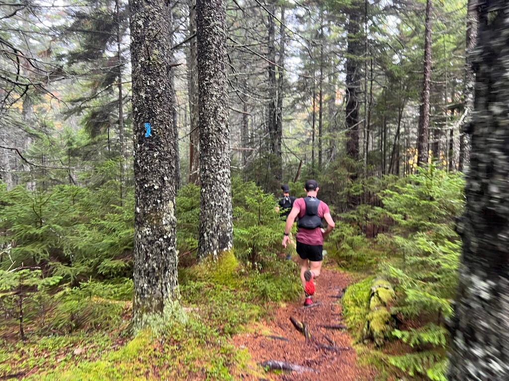
Up and over Day Mountain, then up and over Triad and down to Jordan Pond hugging the water before making your way up to the water fountains and bathrooms there. Drop down to the Asticou trail which speeds its way through the forest before your second carriage road intersection. Hang a right on the second one and you'll see Amphitheatre Trail on your right that follows a stream up to the South Ridge of Sargent. Hang a left to Cedar Swamp summit for a quick tag and back to South Ridge of Sargent and down to the bottom carriage road. Head over on the carriage roads to the Brown Mountain Parking lot, cross the road and take the trail over to Hadlock Pond, across the damn and up Norumbega South Ridge.
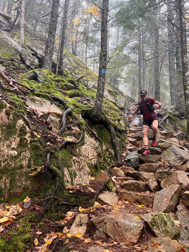
This climb is steady and less steep than most and made up for the ridiculous descent on the other side on Goat Trail. When wet its very sketchy, which is most of the time. Proceed with caution.
Cross the road (good spot for a water drop here, or crew visit as there is parking) and head up Bald, which connects to Parkman, which connects to Grandgent Trail to Gilmore and then the summit of Sargent Mountain. Sargent is the 2nd highest peak on the island a gives a great view of what is to come with Pemetic and then Cadillac Mountain off to your east.
Descend down the southern slope of Sargent South Ridge to the Penobscot Mountain turn off (left) and past Sargent Pond (great swimming and cool off in summer months) and climb up Penobscot Mountain to the summit. Drop down Jordan Cliffs trail to some epic views of The Bubbles and Jordan Pond and upcoming Pemetic Mountain.
Deer Brook trail descends down across the carriage roads all the way to Jordan Pond itself. Hang a left to the Bubbles Divide Trail. This climbs through the birch trees over giant boulders before crested between South and North Bubble. We opted to not include these two Bubble summits due to the large volume of tourists that populate them both and being both short out and backs, it's not worth the irritation for the minimal amount of additional climbing you'd get from it. Its much better to just go straight through and down to the parking lot and across the road to Pemetic.
Pemetic is very steep and going up the ravine (ladders and narrow) or the cliff (extremely steep) is the same distance and a choice you have when you get to the sign. It's a pick your poison moment, so the choice is yours as they go to the same place and cover the same distance (it is only about 0.2 miles long).
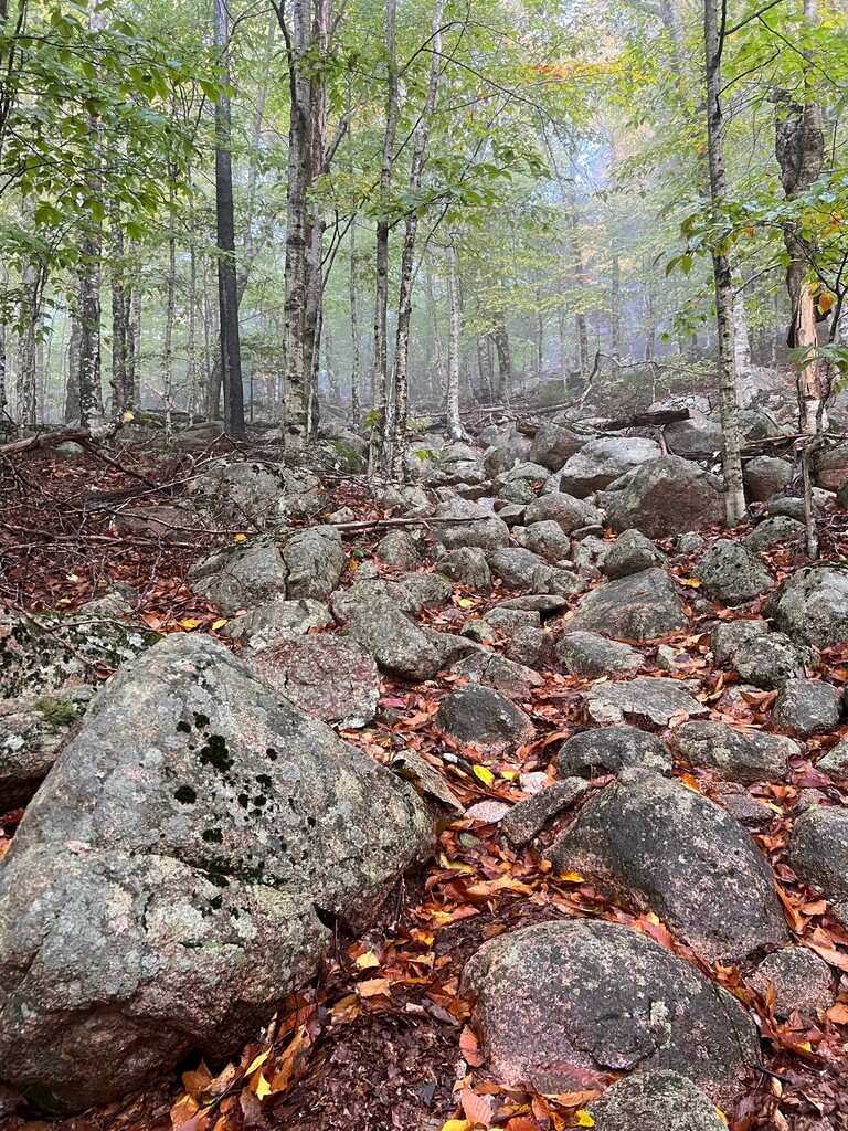
Clearing the top on Pemetic you have to keep going to the actual summit, tag it and head back to take the northeast descent off Pemetic towards Cadillac. This is a very technical descent that when tired, is even more challenging. Very rooty, steep, winding and hard to move quickly. Several incredible lookouts and often a place where bald eagles are flying high above Eagle Lake (in front of you as you descend).
Crossing the carriage road at the bottom of Pemetic you are at Bubble Pond, hang a left along the pond and cross the little outlet stream from the pond to the Cadillac West Face trail. This is the most dangerous trail in Acadia, the most technical and certainly one of the steepest. It has many sections that are traversing along the side of a granite cliff that is often wet and slippery. There are often trees or branches to climb to along the way for added support, but its next level compared to traditional trail running and should not be underappreciated for its difficulty or overlooked by its low elevation. If the weather could have ice on the mountain multiple the risk factor a few times. Otherwise, it's easily done but as Acadia has warning signs for it, I'll add them too. Its a really tough climb at this point in your day and just one of those you have to grunt out. It'll eventually take you to the upper portion of the Cadillac South Ridge Trail where you hang a left and you'll get to the summit.
Fun fact, the actual summit of Cadillac is just above the last rock climb before you open up on the summit plateau. Its on the left with no fanfare but a waymarker in the rocks. Keep going 1/4 mile to the water fountains and gift shop and bathrooms to re-fill.
Cut through the hordes of tourists who drove to the summit over to the east and all the lookouts. You'll see the ocean in every direction from here and the Maine mainland beyond that. Looking across to the east you'll see your next peak, Dorr Mountain which is to come after you take the steep descent into the Gorge, then right back up a steep, but short, ascent onto Dorr. This is another short out and back to the summit marker. Tag it and return to go down Dorr North Ridge Trail.
Heading down Dorr north ridge you are looking out over the town of Bar Harbor, the Porcupine Islands and your ultimate destination. It's more granite bedrock trail running, darting between swaths of cedar, spruce and pines. You'll navigate more boulder piles before crossing the Park Loop Road (cars come from only your left, watch for tourists not looking for runners!) then take a right on Kebo trail all the way down to the cemetery. (No run in New England is complete without a run past a cemetery). Take a left on Kebo Street (road,) then on your right you'll soon see a nice little trail called Great Meadow that runs parallel to the street. Follow that to Spring Street and take Spring to Mt. Desert Street and take a right. This takes you right back to the Village Green. Take the sidewalk on Mt. Desert to the full turn on Main Street back to the clock tower (no cutting through the park).
The Acadia Round puts together every part of Acadia that has made it so special for so many years. The beautiful little town, the faster singletrack, rocky coastlines and crashing waves. The moss lined trails through thick spruce forests and delightfully runnable carriage roads meandering through picturesque forests. Along the ridgelines and mountaintops are views that expand across islands and depending on the season its run, peppered with sailboats and lobstermen. Ocean, mountains, forests, pine and oaks, rivers and lakes and ridgelines.
Clock to clock its some of the most beautiful terrain you can find, with an equal amount of challenge. We ran this to set a baseline for any visitors to attempt the same one day.
Please note that the other direction is not advised due to some of the steep descents being very technical and potentially dangerous (see above for details).
Good luck!
Jeremy, Dylan, & Tony
MDI Locals
Comments
(it is only about 2 miles long
This should read: (It is only about .2 miles long) It's a very short distance, not two full miles.
Hey Jeremy
read this incredible article/route summary last fall during my first trip to Acadia. Was taken back by how incredible the trails are. We’re headed back this fall and interested in giving your route an attempt! Would love to connect if to pick your brain if you don’t mind. Thanks a ton for paving the way and providing all this info!
- Andrew
We've done this route a few times now including a winter version in February 2024. Takes a good bit longer and adds quite a bit to the adventure. https://www.strava.com/activities/10783663881
Ran this route today (slowly) as part of my vacation to Acadia - truly a stellar route.
For anyone interested in this route, a couple of things:
1. As of August 2025, it appears as if they are doing trail restoration on Hunters Beach/Cliff trail. The entrance to the trail (off of Cooksley) was the same, just under construction. Hunter Cliff trail has been re-routed slightly towards the end as you approach the road crossing and the Day Mountain trail. It meets up with the new Day Mountain parking lot (1000 feet down the road compared to the original gpx) and the new trailhead for that trail, so you quickly get back on track. The re-route adds maybe a quarter mile. I was very confused when this re-route happened because my watch said I was off-route and spent a lot of time backtracking to make sure I didn’t miss a turn. Hoping others can avoid this. This was the only time on my run today the gpx file on the site didn’t match the current trails in the park.
2. There is a long gap for water fountains between Jordan Pond and Cadillac Mountain summit. Streams were non-existent when I ran today but there are ponds (Hadlock, Jordan, Bubble) where you can filter. You need a filter (or a water drop).