Route: Chino Hills State Park (CA)

Submitted by Christophe Stahl on Sun, 11/22/2020 - 04:12pm
Location
California, US
Distance
19.19 mi
Vertical Gain
2,479 ft
Description

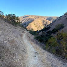
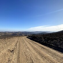
This route in the Chino Hills State Park from the Discovery Center towards the 71 Freeway is a way to try to keep it interesting by using some of the South Ridge Trail for the views and 2 very cute canyons (Easy Street Trail and Bovinian Delight Trail). I guess you can take those one way or the other, but keep them in your run instead of just taking the shortest way with only Telegraph Canyon Road and Water Canyon Trail to make it more enjoyable. Easy Parking at the Chino Hills State Park Discovery Center or right next door at the Carbon Canyon Regional Park (make sure to check the hours if you plan on going there early since parking outside of the parking lots is difficult).

There are basically 3 parallel in this park: The North Ridge, Telegraph Canyon Road and the South Ridge. This route uses the best combination of these. Telegraph Road crosses the park with smallest elevation change and shortest distance, but it stays in the bottom of the canyon and you completely miss the views and nice canyons. On the North Ridge there are not that many views aside from looking down Telegraph Road. This route collects the most interesting places in the park and offers some variety between the canyon and the ridge.

The eastern end of this route is at the largest parking lot on the east end of the park, at the south end of Bane Canyon Road. There is a small parking lot for just 5 cars a few yards away, and the other ones close by are for a horse riding place and a campground.

Images

Comments

User Picture
Profile picture for user Christophe Stahl

Congrats Rebekkah and Georgis!