This route goes up and down the spine of hills along the Dallas-Cedar Hill border, linking up trails in Cedar Hill State Park, Cedar Ridge Preserve and Big Cedar Wilderness Area. It features the biggest hills and biggest adventure that Dallas, TX is prepared to offer the avid trail runner.
The route prioritizes dirt trails and jeep roads to the greatest extent possible, but some pavement running is required to link up the 3 trail systems which are unfortunately disconnected. The route also prioritizes as much vert as possible without retracing steps or taking significant detours. It generally moves in a line from southwest to northeast but some of the trails especially in Cedar Hill State Park and Big Cedar do a lot of winding and doubling back.
Both the start and end points of this route are hike-in/hike-out to create a more aesthetic line, but they are at precise landmarks which are not hard to find once you’re out there in it. Don't forget to pay your entrance fee to Cedar Hill State Park and consider making a donation to Cedar Ridge and Big Cedar!
https://tpwd.texas.gov/state-parks/cedar-hill
https://audubondallas.org/cedar-ridge-preserve/
https://www.trailforks.com/region/big-cedar-wilderness-trails/
Enjoy!
Stage 1: Cedar Hill State Park
Start at the last junction of the "12 mile" DORBA trail (red trail) and jeep road at the southwest end of the DORBA trail system. (This is about 1.45 miles from the trailhead if you access it via the jeep road or 5.75 miles if you go clockwise via the DORBA trail.) The trail wand across from the wood bench is the official starting point.
Run the red DORBA trail counter-clockwise back to the trailhead. The red trail joins with the blue trail and then with the green trail as you get closer to the end. This part of the run includes lots of small limestone ridges in mixed forest as well as a more open section of pocket prairie which is very scenic. Watch for oncoming mountain bikers.
At the DORBA trailhead parking lot, run out past the circle and stay on S. Spine Road as it turns to the right, then turns right again, then turns left at the intersection with Beltline. Run past the first entrance to the Duck Pond Trail (the one with the parking lot) and up the hill until you get to the second entrance to the Duck Pond Trail which is not signed but is obvious. Turn right and then immediately left and run up to the scenic viewpoint hidden in the thicket of junipers. The official Cedar Hill State Park trail map shows this route up to the viewpoint as an out-and-back, but you can (and you should) follow a well-worn use trail off the right side of
the viewpoint to loop back down and connect with the Duck Pond Trail that way. The running here is very scenic, but watch out for thorn bushes and scrub brush that can trip you. If you lose the trail in this small section of prairie, navigate to the telephone pole with the yellow cordon and then follow the succession of other telephone poles which will connect you back to the lower part of the Duck Pond Trail.
Back on the Duck Pond Trail, take a left and run around towards the duck pond. When you get to the junction before the pond, take a left and immediately look for the orange cones and trail wands in front of a boggy clearing. Here you must go off the official trail, stepping through the bog to reach the jeep road that runs along the park's southern boundary, along a ridge. Note: this jeep road is not shown on park maps but you can clearly see it on satellite images.
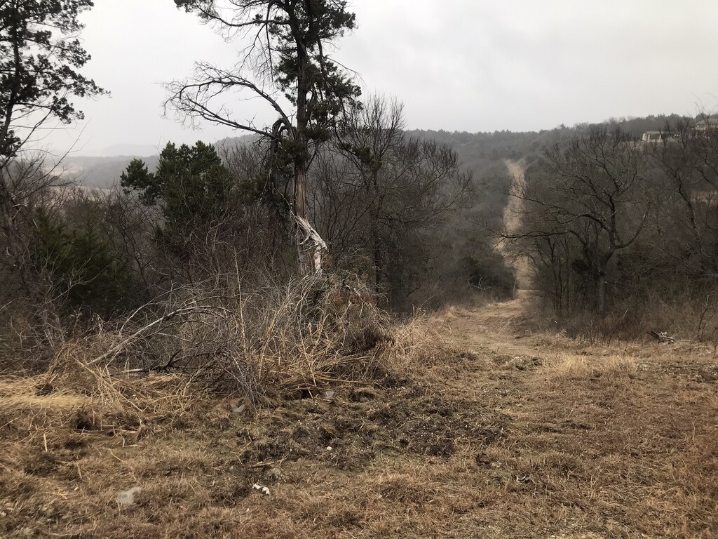
When you get to the jeep road, turn left and go up and down the high ridge. Note the jeep road may be very overgrown with tall grass and/or boggy in parts depending on the season. This part of the route features a lot of vert on a notched ridge and eventually gives you a great view of Joe Pool Lake in the distance on your left. Follow the jeep road until it ends at a wide clearing, then turn right and run down the clearing to get to the entrance road to Cedar Hill State Park.
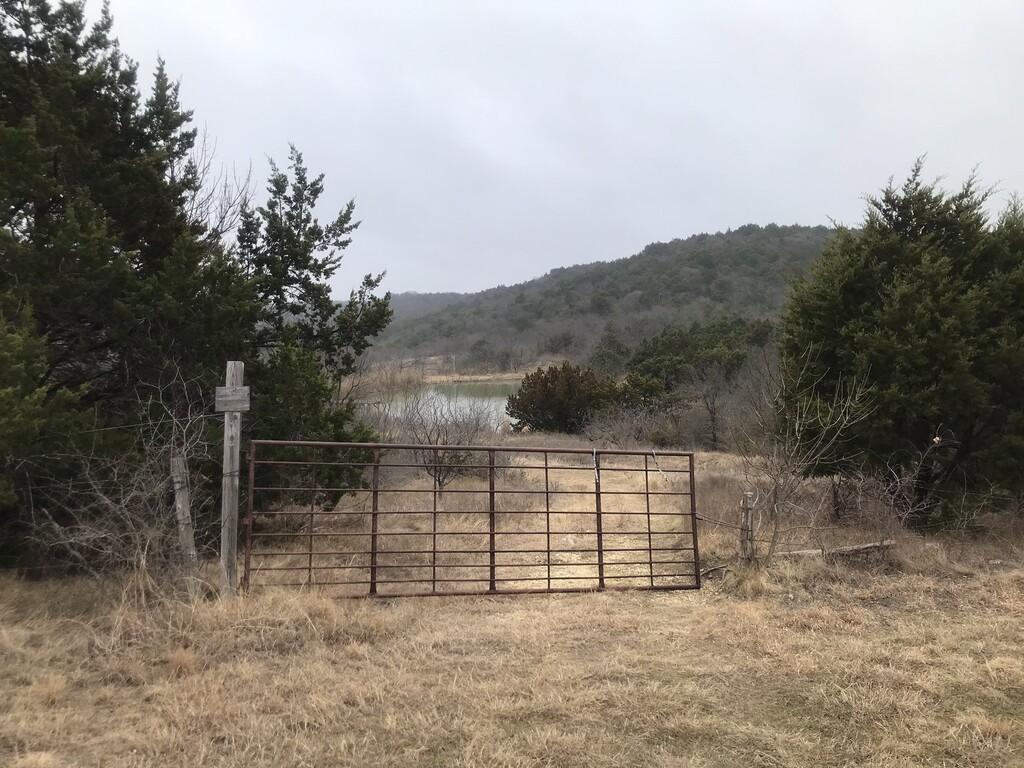
Turn right on the road and exit the park, safely crossing FM 1382 so that you are on the east side of the highway. From there, run left (north) on the highway shoulder or the grass berm for about a mile until you reach a faint jeep road on the right hand side, which takes you up over a small ridge and up to the gated back entrance to Cedar Ridge Preserve. The gate will probably be locked in which case you need to shimmy through or jump it.
Stage 2: Cedar Ridge Preserve
Once inside the preserve, you will see Cattail Pond ahead. Take a right on the trail in front of the pond, and after a short section of boardwalk begin the climb up the Fossil Valley trail. This part of the route takes you over a limestone ridge that is reminiscent of the "Texas Hill Country". At the viewpoint at the top, take the trail to the right to go down the Trout Lily trail. At the bottom take a right at the junction to reconnect with the Fossil Valley trail and begin another climb. At the next junction with the Cattail Pond trail, turn left and run past another viewpoint down to the junction with the Escarpment trail. Turn right and hike or run up the crushed gravel of the Escarpment trail until you are almost at the end, where you should turn left and left again to access the Bluebonnet trail. Run the Bluebonnet trail all the way around, pop out of the trail system and continue through the parking lot to exit Cedar Ridge Preserve. Note: the trail system at Cedar Ridge is extremely well-marked and well-mapped and is arguably the most dramatic scenery of the route but the trails tend to be crowded with people on weekends.
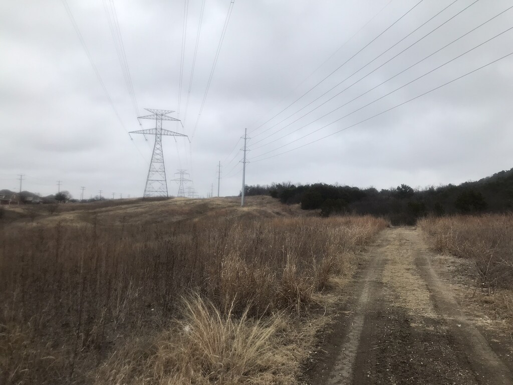
Turn left and run down Mountain Creek Parkway to Wheatland Road, where you should cross the road and keep running down the other side of Mountain Creek Parkway until you get to a steep driveway accessing a utility easement on your right. Above this driveway, a jeep road leads up the hill. Run on the jeep road under the whir of the power lines until you get to the main paved road that cuts through the Big Cedar Wilderness Area and Mountain Creek Community Church atop the ridge.
Stage 3: Big Cedar Wilderness Area
Turn left on the main road and almost immediately look for the gravel gully on your left where you can pick up the Texas Sunset trail going back down the hill. You will run almost the entire length of the Texas Sunset trail, going clockwise against the blazes and signage. This part of the route has a number of very punchy climbs and drops, but in general you go down the hill, climb back up the hill, run along the ridge by the church, go back down the hill, cross the main paved road leading up to Mountain Creek Community Church, then run up a series of switchbacks to gain the ridge for the last time. This is possibly the only trail in North Texas that features switchbacks. When you end up in a clearing with a striking vista and a jeep road heading steeply down the hill to the left, leave the Texas Sunset trail and follow the jeep road down the hill.
From here, it is an open course (choose your own way) through the hill-studded prairie to get to Camp Wisdom Road and the entrance to the Skyline trail. Based on the Strava heat map, the most common route and probably the most efficient one is to run downhill and take the jeep road sweeping around the back of the first power line, turn right and then left to run through the mountain biker "jumps" area, then follow one of the faint jeep roads beyond the last jump until it intersects with the singletrack of the Patriot trail near a small pond. From there follow the Patriot trail left (north) along the edge of the woods, until you can pick up a use trail that takes you across the prairie, doubling back and skirting a power line, and then back into the woods on the Patriot trail to reach Camp Wisdom Road and the junction with the Skyline trail.
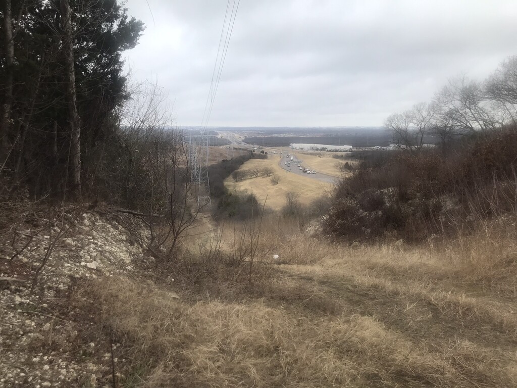
The Skyline trail is across Camp Wisdom Road on the other side and is well-marked with yellow blazes. Follow the yellow blazes as you climb higher and higher and eventually get to a clearing with a scenic view of Highway 1-20, above a very steep jeep road. From this last scenic vista it's a short downhill section to the end of the Skyline trail. The official finish of the route is the speed limit sign on the edge of Camp Wisdom Road.
Comments
This route will no longer work. The first view point that you are supposed to make after the road section leaving the DORBA trail is impassable with brush. The Duck Pond Trail is closed due to a bridge washout and is coned off. The entire section after the Duck Pond Trail is impassable as well. I destroyed a pair of shorts and socks (but was able to save the shoes) from all of the bushwacking. It may have been a jeep road at some point but you can't even tell where. I had to abandon the effort because I was already climbing between branches and was nervous about going over a mile more to get out of the park. Also, on Gaia it showed the route to go slightly outside the park territory and I was nervous about passing on private property since I was sure I was probably already on an unauthorized section. You can find my bushwacking effort here: https://strava.app.link/o0fvOwSbJKb