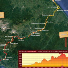
Location
Costa Rica
Distance
264 km
Vertical Gain
5,500 m
Description
GPS Track
COURSE_49728074.gpx554.44 KB
FKTs
Female
Mixed-gender team
Male
| Sandra Mejía Céspedes | 2d 17h 19m 34s |
| Jacqueline Howard, Lindsey McLaughlin | 6d 9h 34m 0s |
| Jose Pablo Cob Barboza, Sandra Mejía | 2d 20h 7m 53s |
| Tommy Braham | 4d 10h 30m 0s |


Comments
2d17h. Wow. Sandra Mejía Céspedes, Jose Pablo Cob Barboza this is unbelievable. Leaving tomorrow morning to Muelle de Goschen to embark on El Camino de Costa Rica on 5th of January. I will attempt an FKT in category Male Supported. Exciting time ahead. News to come!
Sam Charlebois
Congrats everyone! I’m flying out tomorrow. I’m pumped!