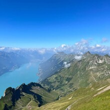
Der Grenzpfad Napfbergland ist ein Fernwanderweg zwischen Emmental und Entlebuch. Ein Weg entlang der Grenzroute zwischen den Kantonen Bern und Luzern wo vor 150 Jahren noch feindliche Scharmützel stattfanden. Grenzen überwinden möchte der Grenzpfad, der von der barocken Anlage des ehemaligen Klosters St. Urban über wildromantische Wege bis auf den Brünigpass führt. Der Weg zieht durch die sanfte Hügellandschaft des Emmentals, durchs Biosphärenreservat Entlebuch und lässt auch aussichtsreiche Gipfel nicht aus: Napf, Wachthubel, Marbachegg und Brienzer Rothorn sind nur einige davon.
The Napfregion Borderpath is a long-distance hiking trail in between the Emmental and the Entlebuch. A trail along the border between the Kantons of Bern and Lucerne where only 150 years ago skirmishes were fought. Crossing boundries is the purpouse of this path, which passes by the baroque monastery in St. Urban and along romantic and diverse trails all the way to Brünig Pass. The trail starts in the rolling hills of Langenthal and the Emmental, traverses the Napf region and some parts of the Biosphere Region of the Entlebuch and takes you up and over the highest peak in the kanton of Lucerne, the Brienzer Rothorn, before ending at Brünig Pass.
The starting point of this FKT route is the first hiking trail signpost at the train station in Langenthal. The "finishline" is the main signpost at the Brünig Pass train station after you pass the thriftshop/Brockenhaus. It has to be run southbound in order to count because of the difference in elevation gain and loss. Have fun on this beautiful and very diverse adventure and check the weather forecast, you don't want to run into thunderstorms up towards the Brienzer Rothorn.
https://www.schweizmobil.ch/de/wanderland/routen/route-065.html
https://grenzpfad.ch/de/


Comments
On the 11th of September at approx. 4am I'll be attempting to set a supported FKT on this route.