https://en.wikipedia.org/wiki/Ko%CA%BBolau_Range
Koʻolau Range is a name given to the dormant fragmented remnant of the eastern or windward shield volcano of the Hawaiian island of Oʻahu. It was designated a National Natural Landmark in 1972.[3]
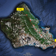
It is not a mountain range in the normal sense, because it was formed as a single mountain called Koʻolau Volcano (koʻolau means "windward" in Hawaiian, cognate of the toponym Tokelau). What remains of Koʻolau is the western half of the original volcano that was destroyed in prehistoric times when the entire eastern half—including much of the summit caldera—slid cataclysmically into the Pacific Ocean. Remains of this ancient volcano lie as massive fragments strewn nearly 100 miles (160 km) over the ocean floor to the northeast of Oʻahu. The modern Koʻolau mountain forms Oʻahu's windward coast and rises behind the leeward coast city of Honolulu — on its leeward slopes and valleys are located most of Honolulu's residential neighborhoods.
View of Koʻolau Range from the top. Kaneohe is visible on the right side
The volcano is thought to have first erupted on the ocean floor more than 2.5 million years ago. It eventually reached sea level and continued to grow in elevation until about 1.7 million years ago, when the volcano became dormant. The volcano remained dormant for hundreds of thousands of years, during which time erosion ate away at the initially smooth slopes of the shield-shaped mountain; and the entire mass subsided considerably. The highest elevation perhaps exceeded 3,000 meters (9,800 ft); today, the summit of the tallest peak, Puʻu Konahuanui is only 3,100 feet.
After hundreds of thousands of years of dormancy, Koʻolau volcano began to erupt again. Some thirty eruptions over the past 500,000 years or so have created many of the landmarks around eastern Oʻahu, such as Diamond Head, Koko Head (Hanauma Bay), Koko Crater, Punchbowl Crater, Tantalus, and Āliapaʻakai, and are collectively known as the Honolulu Volcanic Series.[4] Geologists do not always agree on the dates of these more recent eruptions, some dating them to around 32,000 years ago, others to as recently as 10,000 years ago. Geologists believe that there is at least a remote possibility that Koʻolau volcano will erupt again.
-----------------------------------------------------------------------
It is roughly 50-miles. Chase Norton did it in 8-days in 2012 but there are rumors of others doing it faster. Chase's write up here: www.unrealhawaii.com/2012/05/chase-norton-koolau-summit/
-----------------------------------------------------------------------
Here is more up-to-date info from outsideonline.com (many amazing pictures on that site):
Beyond Oahu’s well-known destinations is the Ko’olau Mountain Range, remnants of the extinct shield volcano that once helped to form the island’s land mass. Exploration of these mountains isn’t new, but it wasn’t until five years ago that the first traverse of the entire range was completed, by Chase Norton, then a PhD student at the University of Hawai’i. (The length of the traverse is unclear. Estimates range between 55 and 80 miles.) Norton spent years working out logistics, locating water sources, and attempting the route multiple times before completing it in eight days in April 2012, using a mix of mountaineering, climbing, route finding, and bushwhacking. For about two years, Norton remained the only person to successfully complete this feat. Then, in January 2014, photographer-filmmaker Ryan Moss completed the route in five and a half days. After Moss’ successful trek, the route saw numerous attempts but fewer than a handful of completions over the next few years. On March 4, 2017, Moss set out to beat his own speed record and succeeded spectacularly, completing the trek solo and unassisted in just four days and seven hours. Just a couple weeks after Moss’ successful traverse, Derek Potter, a Pearl Harbor–based machinist in the U.S. Navy, impressively completed the trek on his first attempt in just three and a half days.

