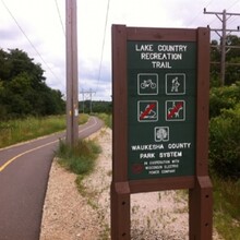
The Lake Country Trail runs from the western edge of Waukesha to Oconomowoc in Wisconsin’s Lake Country area. Most of the trail was built on a former Milwaukee-Watertown Interurban Railway right-of-way, now shared with Wisconsin Electric Power Company overhead electric lines.
The view from the rail-trail is primarily farmland and rolling hills, although adjacent roadways are rarely out of sight. Occasionally, you can catch glimpses of Pewaukee Lake and Upper Nemahbin Lake from the tops of some of the taller hills.
There are a few on-road stretches along the way, including in the quaint downtown area of Delafield. In this community, you can connect to the Cushing Park Road Recreational Trail, which heads south from Main Street to meet the Glacial Drumlin State Trail in 3 miles.
The popular Naga-Waukee Park and Naga-Waukee War Memorial Golf Course are located along the Lake Country trail just to the east of Delafield. Visit the park to enjoy swimming, boating and fishing in Nagawicka or Pewaukee lakes.
Parking and Trail Access
Parking for the Lake Country Trail is available in Oconomowoc at Roosevelt Park on W. Forest Park Street. Farther east, a trailhead offering parking and restrooms can be found on Delafield Road at the western edge of Upper Nemahbin Lake.
In Delafield, park at the Fish Hatchery Sports Complex on Main Street. Restrooms are also available there. To the east, parking, restrooms and picnic areas can be found at several locations in Naga-Waukee Park. Access the park from State Route 83 or Maple Avenue.
The easternmost Landsberg Center Trailhead is located in Waukesha on Golf Road. The large facility provides ample parking and restrooms.

