Route: Lower to Upper Baughman Trail, uphill then downhill, out and back (PA)

Submitted by Brynn Cunningham on Thu, 07/07/2022 - 04:07am
Location
Pennsylvania, US
Distance
6.1 mi
Vertical Gain
1,164 ft
Description

Baughman Trail runs along the Youghiogheny River in Ohiopyle State Park. The trailhead begins by the Middle Yough takeout. The first two miles of Lower Baughman Trail travels uphill to the Baughman Rock Overlook, a popular stop for tourists, then turns to Upper Baughman, a one-mile section of rock gardens and narrow, technical single track, which ends when you get to the paved road, Sugarloaf Road.


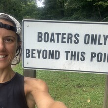
How to run the route: Park in the old train station/ visitor center parking lot next to the Middle Yough Takeout parking area and across from the Ohiopyle House Cafe. Begin and finish at the sign in the photo that says "BOATERS ONLY BEYOND THIS POINT." The sign is located where the parking lot for the general public ends and the parking lot for boaters begins. Run away from the center of town first on the pavement in the parking lot then to the rail trail of the Great Allegheny Passage for a couple hundred yards. You will see the trailhead on the right across from the Middle Yough Takeout hill. Turn right then immediately left to get onto Baughman Trail. The first two miles are uphill, all runnable. You will pass the Baughman Rock Overlook, where Upper Baughman turns to narrow single track. Run until you hit the pavement, touch it with both feet, and turn around. On your run back downhill, run up the flat rock to the Baughman Rock Overlook and hit the railing, then return to the trail. The entire route is runnable, rocky and fun.


A Duathlon and River Plunge: To warm up, I mountain biked up Sugarloaf Trail and down Baughman Trail, the five-mile loop with 831 feet of elevation gain, in 49 minutes, making this a duathlon. Once off the bike, I changed shoes and shorts, grabbed my handheld bottle and took off. After the bike/run, I jumped in the Yough River to cool off and rinse the dirt from my legs. It had rained all night the night before, so the trails were muddy and slick. Water temperature was 65 degrees that day, the warmest it gets in the summertime.


Note: On the day of the FKT, my watch clocked 6.09 miles. When I run at slower paces, my watch clocks a bit more distance, closer to 6.5. Just something to be aware of - not all sport watches give the same distance on any given day/ pace. 

GPS Track
Images