Location
Washington,
US
Description
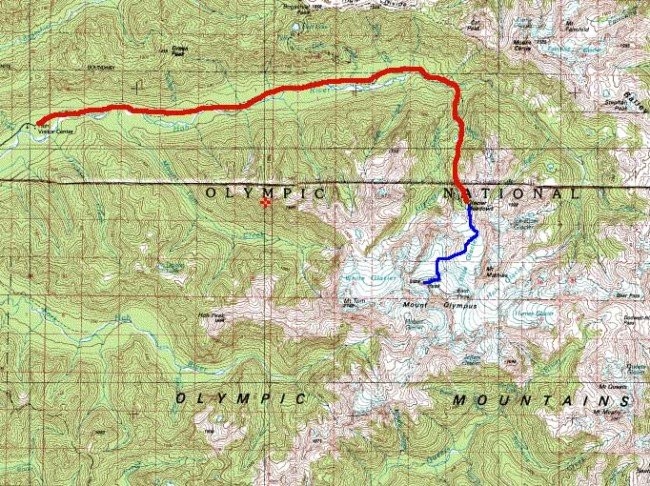
47.7998096, -123.7065779
FKTs
Male
Mixed-gender team
Female
| Sean O'Rourke | 10h 12m 0s | ||||
| Leor Pantilat | 11h 6m 0s | ||||
| Leor Pantilat | 11h 30m 0s |
| Monica Moline, Adam Moline, Emilio Pelaez | 14h 43m 38s |
| Samantha McCann | 14h 49m 50s |
Images
This route on the old FKT site
Comments
On Saturday, June 16, 2018 I will be attempting the car to car, unsupported FKT of this route. I will be starting at 2am from the Hoh Visitor Center. Spot Tracker live tracking will be available at: https://share.findmespot.com/shared/faces/viewspots.jsp?glId=0Z3VFWHEsC…
I will also be tracking with Strava and will write a trip report afterwards.
On Saturday, July 14th, 2018 I will be attempting the car to car, unsupported FKT of this route again. I will be starting at 2am from the Hoh Visitor Center. Spot Tracker live tracking will be available at: https://share.findmespot.com/shared/faces/viewspots.jsp?glId=0Z3VFWHEsC…
I will also be tracking with Strava and will write a trip report afterwards.
Start time will be between 2am-4am
On Thursday, July 19th, 2018 I will be attempting the car to car, unsupported FKT of this route again. I will be starting around 3:30-5:00AM from the Hoh Visitor Center. Spot Tracker live tracking will be available at: https://share.findmespot.com/shared/faces/viewspots.jsp?glId=0Z3VFWHEsC…
I will also be tracking with Strava and will write a trip report afterwards.
Nice Monica!!
On 8/11/24 I completed this route in 12 hours, 42 minutes. I was just a tad slow from record pace to the first glacier, but really lost time on the technical climbing on the snow dome and rock scramble. I decided to shut it down and cruise it in once I realized I was over an hour slower than Sean to the summit. Sean’s time is super stout and I see now how his record has lasted so long!
https://strava.app.link/51wGIVoD0Lb
Oops
https://strava.app.link/ZdmYqA2D0Lb