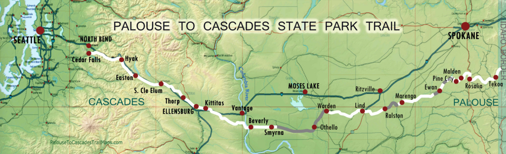
The Palouse to Cascades State Park Trail gives hikers, cyclists and equestrians a taste of Washington’s scenic diversity from the forested Cascade Mountains to the arid scrublands of eastern Washington. Sitting on the historic Chicago-Milwaukee-St. Paul-Pacific Railroad nicknamed the "Milwaukee Road", the trail runs from Cedar Falls near North Bend (railroad milepost 2136) to the Idaho border (railroad milepost 1850).
More info:
- https://parks.wa.gov/find-parks/state-parks/palouse-cascades-state-park-trail
- https://www.palousetocascadestrail.org
- https://palousetocascadestrailmaps.com
- Palouse to Cascades State Park Trail WEST of the Columbia River: https://ridewithgps.com/routes/36054769
- Palouse to Cascades State Park Trail EAST of Columbia River: https://ridewithgps.com/routes/37024565
Follow the official trail as best as possible. In the few cases where the trail is under construction or closed, please follow official detours and explain where and what the detours were in your recap. Please refer to the official trail site for up to date information on closures.
Ellen Lavoie posted the route and some detail (see also her FKT page):
I completed the entire Iron Horse/John Wayne Trail (also known in sections as the Milwaukee Road) as a run. The trail utilized the old Chicago, Milwaukee, St. Paul and Pacific railroad bed (also known as just the Milwaukee Road) that was designated as a recreational trail in 1985. Due to some local landowner disputes and active rail areas, parts of the official trail also utilizes local dirt and paved roads that allow the recreationalist to "pick" their route. I chose roads that kept me away from traffic as much as possible. The total mileage recorded on the tracker came out to 296 miles although the setting was set to take points in such a timely manner that some of the mileage is left out. Actual mileage turns out to be 305 miles as I did it. Parts of the trail are inaccessible but are re-routed by road. Those sections were completed on nearby road re-routes. One exception that takes the original railroad route across the Columbia River is forbidden to travel on the trestle and going around on the I-90 bridge by pedestrians or bicyclist is illegal. In that case, I ran to the very edge of the trail where the trestle is fenced off on either side and to cross the river I was transported by car.
Here is the Garmin tracker info: connect.garmin.com/modern/activity/1985036193/share/0?lang=en