The route is a very scenic enchainment of narrow ridges & peaks in the Venedigergruppe / Osttirol / Austria. It starts from the Sajat-hut at 2600m high above Prägraten in the beautiful Virgen valley, with a steep via ferrata D/E followed by mixed terrain in terms of scrambling till UIAA II & easier ferrata parts up till C. You will encounter seven peaks including 3 above 3000m as well as breathtaking views, including the glaciers around Großvenediger – all being part of National Park “Hohe Tauern”.
Find the original text from https://www.sajathuette.at/sajatkrone/ translated:
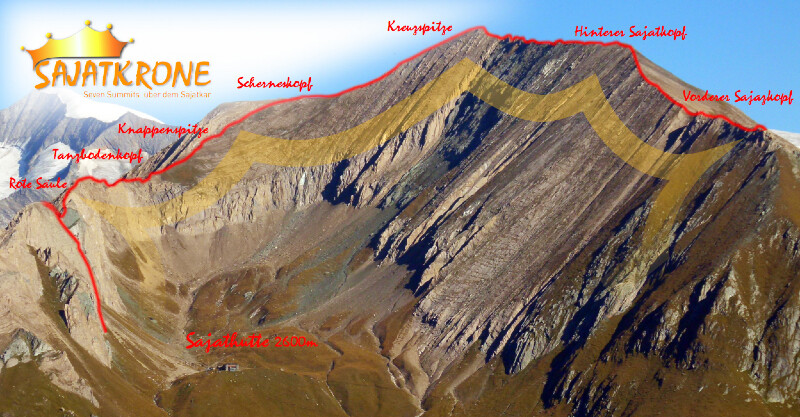
Summit dream "Sajat Crown" Seven Summits above the Sajatkar
Let's dive into the lonely and breathtaking summit world around the Neue Sajathütte! Already the panorama from the hut perspective and the Sajatkar is grandiose - but what opens up to our views from the surrounding peaks and ridges is many times more overwhelming. With the new climbing facility and route guidance from the Sajatscharte via Tanzbodenkopf and Knappenspitze to Scherneskopf, the "Sajatkrone" is now perfect - just in time for the tenth anniversary of the New Sajathütte. The ridge with its seven peaks is the superstar - glacier, mountains and valleys are our backdrop!
But one thing is important:
The Sajat Crown is not a hiking trail! Its complete ascent is a high alpine and demanding day tour. Partial sections are quite an experience due to several entry and exit possibilities. This is an advantage in case of weather change, exhaustion or lack of time. A complete via ferrata equipment (harness, via ferrata brake, helmet) is indispensable. Additional safety equipment (possibly rope, carabiners, webbing slings, etc.) is useful in early summer, autumn or after a sudden change in weather, as snowfields can be expected, especially on the shady side. Inexperienced climbers should definitely entrust themselves to a mountain guide.
The individual sections
New Sajathütte - Red Column (2820m) via ferrata - two access variants
Direct access via "Via Ferrata di Stefano" (D/E) or normal access (B/C)
Time required: 1-1.5 hours
Cancelation possible: Via normal route (partly secured by wire rope) to the hut in about 30 minutes.
Red column - north ridge - Sajatscharte (2750m) UIAA II - partly secured by wire ropes
From the summit cross back over the ridge. On the left hand side to the entrance to the north ridge. Orientation skills are especially important on the unsecured passages. The route runs mostly left below the ridge (footprints). Before reaching the Sajatscharte on the west side, slightly descending in brittle blocks to the high trail.
Time required: 1 hour.
Possible to break off the tour: Descent via the high trail to the Sajathütte in 20 min
Sajatscharte - Tanzbodenkopf (2879m) - Knappenspitze (2888m) - junction of the Scherneskopf ascent
The royal stage of the tour (UIAA II) is partially insured with wire ropes. Caution is advised, as there is an increased risk of falling rocks!
From Sajatscharte directly to the summit of Tanzbodenkopf (partly old markings) and further below the ridge to the foot of the Knappenspitze. Over friction plates (secured with wire rope) to the summit. Now the most rustic section begins: After a short ridge passage, climb down on the west side and mostly on the shady side below the walls to a large clamp block. Climb over/around this block and back to
the ridge. Now in airy up and down to the path that leads from the Sajatkar up to Kreuzspitze.
Time required: 1.5-2 hours.
Cancelation of the tour possible: Via the climbing facility back to the Sajathütte in about 45 minutes.
Scherneskopf (3043m) - Kreuzspitze (3164m)
Then follows the ascent to the highlight: on a well-marked trail to the Kreuzspitze with its distinctive summit cross and a magnificent 360° summit panorama.
Time required: 45-60 min from the junction of the ascent
Kreuzspitze - Rear Sajat head (3098m) - Front Sajat head (2918m)
The furious finale! From the summit cross, past the meteorological station, shortly southeast of the jagged ridge, descend into the craggy flank, past a wide ridge tower and back to the
Ridge (UIAA I-II, well marked). Now follow the markings in southern direction on the slightly sloping mostly eastern (right) side of the ridge to the Vorderen Sajatkopf.
Time required: 1-1.5 hours
Tour interruption not possible!
Descent from the Vorderen Sajatkopf to the "window" on the high trail - return to the Sajathütte
The descent offers no more difficulties and is well marked. Nevertheless, since it is steep and sometimes slippery, all concentration should be called up again before the high trail leads us back to the Sajathütte.
Time needed: 1-1,5 hours