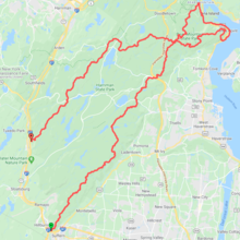
Route: Suffern-Bear Mountain - Ramapo-Dunderberg Ribbon (NY)

Submitted by dawnofnight on Mon, 06/08/2020 - 11:54am
Location
New York, US
Distance
49 mi
Vertical Gain
12,500 ft
Description

The Suffern-Bear Mountain and Ramapo-Dunderberg Ribbon covers the entirety of the Suffern-Bear Mountain and Ramapo-Dunderberg trails. These are connected using the Red (1777) trail and Jones Point Road. SBM and RD are the two trails that cross the entire length of the Harriman State Park and this route uses the obvious connection between the two. This is almost 50 miles in length and 12500 feet of elevation gain in total.

Note that you can close the loop by running along the Orange Tpk, but that's not part of the FKT.

Images