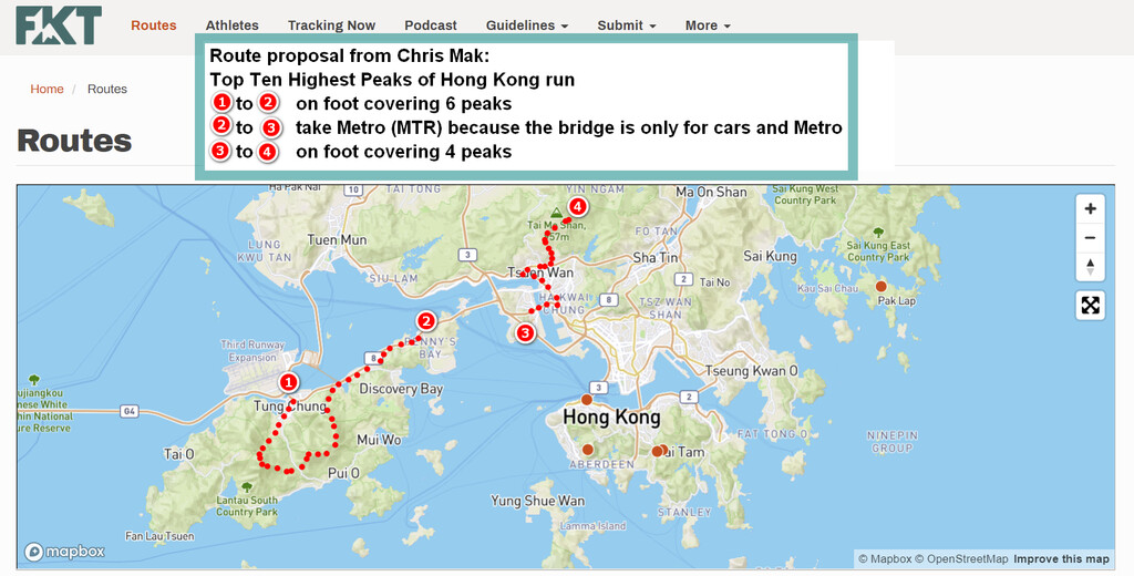
With over 7.5 million residents of various nationalities in a 1,104-square-kilometre (426 sq mi) territory, Hong Kong is one of the most densely populated places in the world. Hong Kong has proudly set aside 40% of land for country parks and nature reserves. As such hiking is a popular activity attracting many tourists from all over the world. This route starts at sea level and goes to the top of each of the 10 highest peaks in Hong Kong. The choice of route is your own, and you may visit the peaks in any order. Time begins at sea level, and ends at the summit of the final peak. You must do the entire distance on foot, EXCEPT the Tsing Ma Bridge, on which pedestrians are not allowed. For that section you may take public transportation or drive between the Sunny Bay and Tsing Yi MTR stations. The FKT includes the time required to get across the bridge, whether by car or by public transportation.
The peaks are as follows:
Tai Mo Shan ( 大帽山/大霧山 ), 957m, 22°24′36.423″N, 114°7′28.542″E
Lantau Peak/ Fung Wong Shan ( 鳳凰山/鳳峰/爛頭山/鴉雀口山 ), 934m, 22°14′57.38″N, 113°55′11.77″E
Sunset Peak/Tai Tung Shan ( 大東山/大洞/大峒/日落峰 ), 869m, 22°15′26.12″N, 113°57′9.74″E
Sei Fong Shan ( 四方山/大瀝 ), 785m, 22°25′2.95″N, 114°8′11.87″E
Wo Yeung Shan ( 禾秧山/假大帽 ), 771m, 22°24′8.1″N, 114°7′48.64″E
Lin Fa Shan ( 蓮花山 ), 766m, 22°15′58.69″N, 113°58′14.86″E
Miu Ko Toi ( 妙高台 ), 765m, 22°24′13.15″N, 114°7′15.05″E
Nei Lak Shan ( 彌勒山/昂平山 ), 751m, 22°15′47.29″N, 113°54′37.43″ E
Yi Tung Shan ( 二東山 ), 747m, 22°15′32.66″N, 113°57′49.22″E
Sam Shan Toi( 三山台(北峰)/牛牯塱山 ), 721m, 22°16′27.28″N, 113°58′8.99″E
Ap Kuk Lek ( 鴨腳瀝 ), 721m, 22°16'27.5"N, 113°58'8.68"E
(Note that Sam Shan Toi and Ap Kuk Lek are the same height and are very close together - you should do both.)
Race Timing Solutions - Tai Mo Shan Top Challenge 大帽山精準賽2017 (raceresults.com.hk)
Tough Lantau 2 Peaks trail race pushes runners to their limits on brutal climbs and descents | South China Morning Post (scmp.com)