VERSÕES EM PORTUGUÊS E INGLÊS
(PORTUGUESE AND ENGLISH VERSIONS)
ULTRA OURO FINO
CASA BRANCA – MINAS GERAIS – BRASIL
OBJETIVOS COMO FKT OFICIAL:
- Estimular a prática da corrida em trilha e o contato com a natureza.
- Promover a melhora da saúde física e mental, bem como da qualidade de vida.
- Mostrar as riquezas naturais, históricas e culturais da região e contribuir para sua proteção e preservação.
- Estimular o turismo e a economia local.
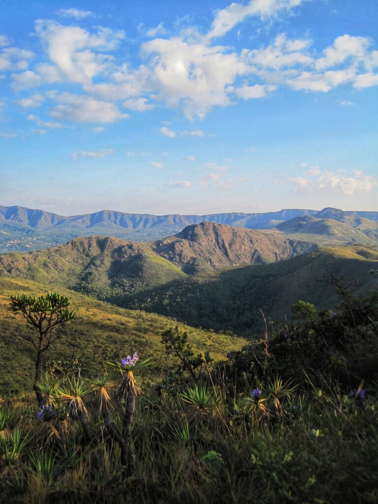
O percurso da ULTRA OURO FINO começa e termina em CASA BRANCA e é formado por uma conexão de trilhas e caminhos das SERRAS DA CALÇADA e do ROLA-MOÇA. Ambas muito frequentadas por praticantes da caminhada e corrida em trilha e do Mountain Bike.
É denominado de “ULTRA OURO FINO”, pois percorre quase toda a extensão da SERRA OURO FINO, um imponente maciço, pertencente à SERRA DA CALÇADA, que abriga não só uma vegetação exuberante, como também importantes vestígios arqueológicos.
Percurso disponível no WIKILOC:
- Percurso oficial para navegação:
https://pt.wikiloc.com/trilhas-corrida-em-montanha/ultra-ouro-fino-percurso-oficial-para-navegacao-instagram-ultraourofino-105121885
- Percurso realizado em 04/06/2022:
https://pt.wikiloc.com/trilhas-corrida-em-montanha/ultra-ouro-fino-04-06-2022-104641748
Instagram: ultraourofino.
CASA BRANCA
Casa Branca nos remonta ao século XVII, quando as primeiras casas do povoado foram erguidas, por volta de 1674, em função da mineração de ouro na região.
Atualmente, Casa Branca é um distrito do município de Brumadinho e situa-se a cerca de 35 km de distância do centro de Belo Horizonte, a capital do Estado de Minas Gerais.
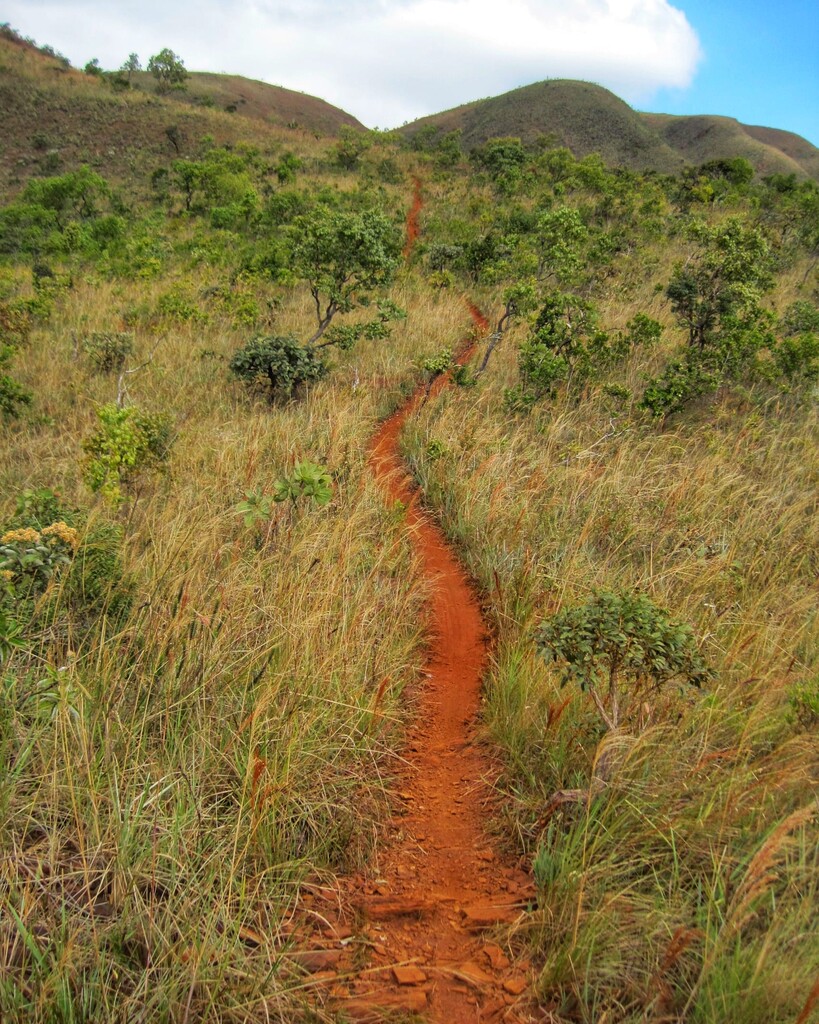
Localiza-se no vale do ribeirão Casa Branca, que tem suas nascentes nas serras da Calçada e do Rola-Moça. Devido ao seu clima agradável e relevo montanhoso com trilhas, mirantes, riachos e cachoeiras, é propícia para a prática da caminhada e corrida em trilhas, bem como do Mountain Bike. Além disso, Casa Branca oferece aos visitantes diversas opções de hospedarias, bares e restaurantes.
SERRA DA CALÇADA
Localizada nos municípios de Brumadinho e Nova Lima, correspondendo à porção norte da Serra da Moeda, “braço” meridional da Serra do Espinhaço, a Serra da Calçada insere-se no chamado Quadrilátero Ferrífero, uma das áreas de maior concentração de minério de ferro do mundo e na Área de Proteção Ambiental Sul da Região Metropolitana de Belo Horizonte (APA-SUL RMBH), uma importante unidade de conservação de uso sustentável.
Lugar de beleza cênica, com ecossistemas raros, possui uma enorme biodiversidade e um riquíssimo patrimônio natural, histórico e cultural. Pinturas rupestres, fragmentos de cerâmica e outros utensílios encontrados em abrigos rochosos e cavernas testemunham a presença humana na Serra da Calçada desde tempos pré-históricos.
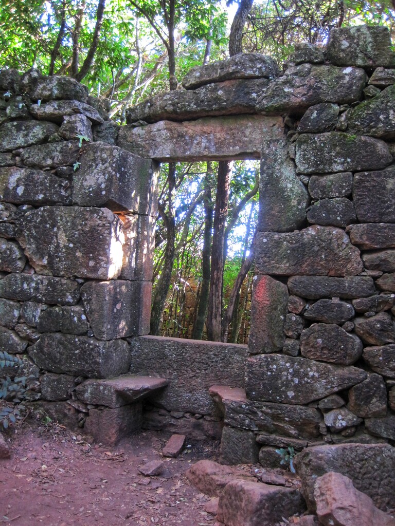
No âmbito da história mais recente (final do século XVII e século XVIII), no período do Brasil Colônia, a ocupação dessa região foi marcada pela mineração de ouro. É no contexto dessa atividade econômica que se enquadram os principais vestígios de arqueologia histórica da Serra da Calçada, com destaque para o “Forte de Brumadinho”, que foi a principal referência para as atividades de extração auríferas ali desenvolvidas no chamado “ciclo do ouro”.
O Forte de Brumadinho, construído nas primeiras décadas do século XVIII, foi, na verdade, a sede de uma grande fazenda voltada à mineração aurífera, tendo a agricultura e a pecuária a função apenas de subsidiar tal atividade. O Forte é apenas parte de todo um complexo minerário do qual ainda restam inúmeros vestígios, tais como: ruínas de pequenas casas edificadas com pedras, tanques para a decantação da lama aurífera (mundéus), diques e represas, várias “bocas” de galerias escavadas na rocha, muros, arrimos e outras estruturas de pedras, além de um grande sistema de canais que captava a água em vários córregos e a levava para o interior das áreas de lavra.
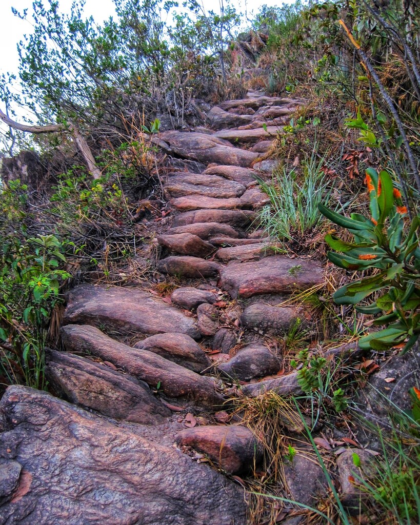
Não menos importantes são os calçamentos de pedras encontrados em várias trilhas da Serra da Calçada, que provavelmente recebe tal denominação em função destes. Tais trilhas calçadas facilitavam não só a execução das atividades minerárias ali presentes, como também serviam como acesso a outros antigos núcleos de mineração e fazendas da região.
A mineração do ouro foi o grande motor da ocupação colonial em toda a Serra da Calçada e, atualmente, a região sustenta um segundo ciclo de mineração, desencadeado a partir do início do século XX, agora voltado para extração do ferro. Assim, toda a história moderna, desde a ocupação colonial até os dias atuais, tem como pano de fundo a exploração mineral.
SERRA DO ROLA-MOÇA
O nome curioso vem de um “causo” mineiro imortalizado pelo escritor Mário de Andrade num poema. Ele conta que um casal, após a cerimônia de casamento, cruzou a serra de volta para casa, ao que o cavalo da moça escorregou no cascalho e caiu no fundo do grotão. O marido, desesperado, esporou seu cavalo ribanceira abaixo e, depois da tragédia, o nome “rola-moça” teria se perpetuado como apelido da serra.
O Parque Estadual da Serra do Rola-Moça (PESRM) localiza-se nos municípios de Belo Horizonte, Nova Lima, Ibirité e Brumadinho. É uma das mais importantes áreas verdes do Estado de Minas Gerais e é considerado o terceiro maior parque de preservação ambiental em área urbana do Brasil.
Possui seis importantes mananciais responsáveis pelo abastecimento de água de parte da Região Metropolitana de Belo Horizonte. São eles: Rola-Moça, Taboões, Bálsamo, Catarina, Barreiro e Mutuca. Todos declarados pelo Governo Estadual como Áreas de Proteção Especial (APE).
O bioma é de Cerrado e Mata Atlântica, com ocorrência de campo rupestre ferruginoso, muito raro, sendo encontrado apenas em Minas Gerais, no quadrilátero ferrífero, e em Carajás, no Estado do Pará.
Sua fauna é bastante diversificada e possui espécies como: veado campeiro, onça parda, jaguatirica, gato mourisco, gato do mato, lobo-guará, raposa, cachorro-do-mato, mão-pelada, coati, irara, lontra, ouriço, preá, tamanduá-de-colete, tatu-peba, tatu-galinha, carcará e várias outras espécies.
Em relação à flora, são encontradas orquídeas, bromélias, candeias, jacarandá, cedro, jequitibá, arnica e a canela-de-ema, que se tornou o símbolo do Parque.
Além de paisagens de beleza singular e uma rica biodiversidade, o Parque possui várias trilhas e diversos atrativos, tais como a Plataforma de Observação Astronômica Prof. Francisco Prado, o Escadão do Rola-Moça, com cerca de 357 degraus de madeira, a Cachoeira das Pitangueiras e mirantes que proporcionam ampla visão das serras da região e dos municípios circunvizinhos, sendo os mais visitados o Mirante Três Pedras, Mirante dos Planetas e o Mirante do Jatobá.
Sua missão é “Preservar e conservar os mananciais e os campos ferruginosos, buscando a harmonia entre as atividades da comunidade e a proteção da biodiversidade.”
Referências Bibliográficas:
1-BORGES, G. C. (org.). Patrimônio Cultural da Serra da Calçada: Relatório de Monitoramento. Associação para a Recuperação e Conservação Ambiental em Defesa da Serra da Calçada (ARCA-AMASERRA). Relatório Técnico. Belo Horizonte, Minas Gerais, 2008, 120 p.
2-Casa Branca (Brumadinho). Wikipédia, 2020. Disponível em: <https://pt.wikipedia.org/wiki/Casa_Branca_(Brumadinho)>. Acesso em: 01/06/2022.
3-Casa Branca. Secretaria de Estado de Cultura e Turismo do Governo de Minas Gerais, 2017. Disponível em: <https://www.minasgerais.com.br/pt/atracoes/brumadinho/historia/casa-branca>. Acesso em: 01/06/2022.
4-Conheça Casa Branca. Viver Casa Branca, 2022. Disponível em: <https://www.vivercasabranca.com.br/conheca-casa-branca>. Acesso em: 01/06/2022.
5-Parque Estadual da Serra do Rola-Moça. Instituto Estadual de Florestas (IEF), 2021. Disponível em: <http://www.ief.mg.gov.br/component/content/198?task=view>. Acesso em: 01/06/2022.
6-Parque Estadual da Serra do Rola Moça. Portal Belo Horizonte – BELOTUR – PBH, 2022. Disponível em: <http://portalbelohorizonte.com.br/o-que-fazer/ao-ar-livre-e-esportes/parque/parque-estadual-da-serra-do-rola-moca>. Acesso em: 01/06/2022.
7-Parque Estadual Serra do Rola Moça. Instituto Estrada Real, 2022. Disponível em: <https://institutoestradareal.com.br/tema/natureza/atrativo/parque-estadual-serra-do-rola-moca-2/>. Acesso em: 01/06/2022.
PERCURSO DA ULTRA OURO FINO
Começa e termina na IGREJA MATRIZ DE SÃO SEBASTIÃO, em CASA BRANCA, passando por trilhas e caminhos abertos ao público das SERRAS DA CALÇADA e do ROLA-MOÇA, percorrendo os municípios de BRUMADINHO, NOVA LIMA, IBIRITÉ e BELO HORIZONTE.
Na SERRA DO ROLA-MOÇA, o percurso passa próximo a uma ÁREA DE MINERAÇÃO. O forte CONTRASTE entre a BELEZA DA SERRA e a DESTRUIÇÃO NA CAVA DA MINA é um lembrete do IMPACTO que essa atividade tem na região e a importância de PRESERVAR as maravilhas naturais remanescentes.
Os DADOS NÚMERICOS a seguir são APROXIMADOS e podem sofrer VARIAÇÕES.
- DISTÂNCIA: 52,43 km.
- DESNÍVEL POSITIVO: 2.095 m.
- NÍVEL: Difícil.
TERRENO
- Trilhas: 34,18 km (65,32 %).
- Estradinhas de terra: 15,38 km (29,39 %).
- Ruas com calçamento: 2,00 km (3,82 %).
- Rodovia asfaltada: 0,76 km (1,45 %).
ATRATIVOS
São elementos NATURAIS, HISTÓRICOS e CULTURAIS presentes no percurso, com destaque para o CALÇAMENTO DE PEDRAS NA SUBIDA DA SERRA OURO FINO, os MUROS DE PEDRAS, o MURO DE ARRIMO e o FORTE DE BRUMADINHO, vestígios da MINERAÇÃO DE OURO ocorrida na região no SÉCULO XVIII.
Destaca-se também, na SERRA DA CALÇADA, uma bela CANDEIA que é SÍMBOLO DA TRAVESSIA BOI PRETO (Instagram: boipretoultra), uma das mais BONITAS e DESAFIADORAS ultramaratonas do Brasil, registrada oficialmente no FKT.
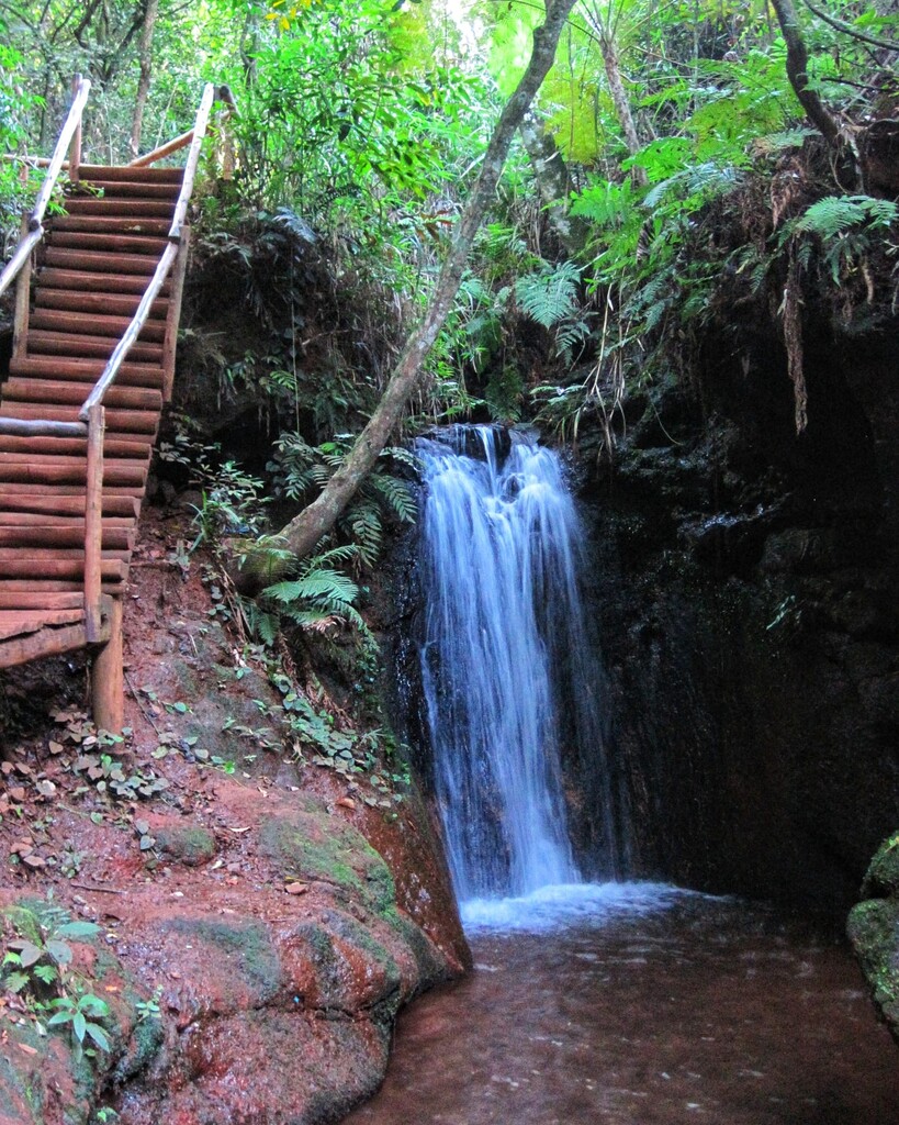
Além dos atrativos citados, estão presentes, ao longo do percurso, diversos MIRANTES, RIACHOS, a CACHOEIRA DAS PITANGUEIRAS, o ESCADÃO DO ROLA-MOÇA, a PLATAFORMA DE OBSERVAÇÃO ASTRONÔMICA PROF. FRANCISCO PRADO, o TANQUE COM PINTURA (antiga caixa d’água), a SANTINHA DA SERRA DA CALÇADA e a MANDALA.
ATRATIVOS E QUILOMETRAGEM – SENTIDO HORÁRIO / ANTI-HORÁRIO
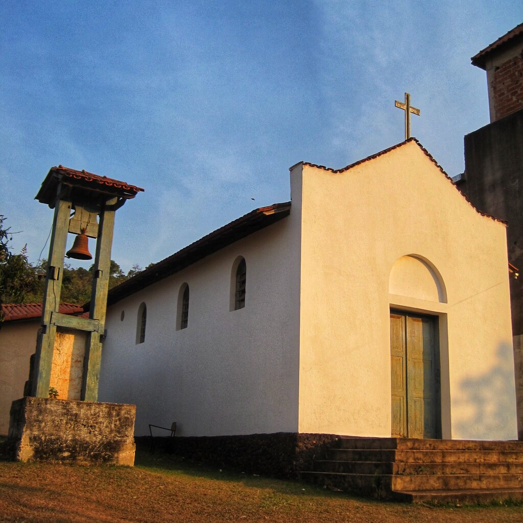
- Igreja Matriz de São Sebastião em Casa Branca/MG – km 0,00.
- *Calçamento de Pedras na subida da Serra Ouro Fino (século XVIII) – km 2,83.
- Mirante para Casa Branca na Serra Ouro Fino – km 3,15.
- Mirante do Jatobá – km 9,67 / km 42,56.
- Mirante dos Planetas – km 10,68 / km 41,55.
- Cachoeira das Pitangueiras (queda d’água sem poço) – km 13,30 / km 38,93.
- Escadão do Rola-Moça (cerca de 357 degraus de madeira) – km 13,65 / km 38,58.
- Mirante para a mata da Gruta da Cuca – km 18,11 / km 34,12.
- Mirante Três Pedras – km 18,34 / km 33,89.
- Plataforma de Observação Astronômica Prof. Francisco Prado – km 21,91 / km 30,32.
- Tanque com pintura (antiga caixa d’água) – km 32,11 / km 20,12.
- Mirante – km 32,67 / km 19,56.
- Riacho com pocinhos adequados para banho – km 32,99 / km 19,24.
- Mirante dos Cristais – km 33,64 / km 18,59.
- *Muro de Pedras (século XVIII) – 34,49 km / km 17,74.
- *Muro de Pedras (século XVIII) – 34,60 km / km 17,63.
- Riacho – km 34,73 / km 17,50.
- Riacho – km 34,95 / km 17,28.
- Mirante do Forte de Brumadinho – km 35,71 / km 16,52.
- Riacho – km 39,69 / km 12,54.
- *Árvore símbolo da Travessia Boi Preto (Boi Preto Ultra) – km 41,25 / km 10,98.
- Santinha da Serra da Calçada – km 41,53 / km 10,70.
- Riacho – km 42,70 / km 9,53.
- *Muro de Arrimo (século XVIII) – km 42,70 / km 9,53.
- *Forte de Brumadinho (século XVIII) – km 43,16 / km 9,07.
- Riacho – km 46,79 / km 5,44.
- Mandala (Mirante 360° na Serra Ouro Fino) – km 47,87 / km 4,36.
PONTOS DE ÁGUA
Sugerimos NÃO CONSUMIR as águas dos RIACHOS e CACHOEIRA. Caso o consumo seja necessário, use algum PURIFICADOR DE ÁGUA (ex.: Clorin).
PONTOS DE ÁGUA E QUILOMETRAGEM – SENTIDO HORÁRIO / ANTI-HORÁRIO
- Cachoeira das Pitangueiras (queda d’água sem poço) – km 13,30 / km 38,93.
- Bebedouro no Centro Integrado de Operações do PESRM – km 15,52 / km 36,71.
- Bebedouro na Portaria Jardim Canadá do PESRM – km 21,69 / km 30,54.
- Riacho com pocinhos adequados para banho – km 32,99 / km 19,24.
- Riacho – km 34,73 / km 17,50.
- Riacho – km 34,95 / km 17,28.
- Riacho. Na época seca, fica com muito pouca água – km 39,69 / km 12,54.
- Riacho – km 42,70 / km 9,53.
- Riacho – km 46,79 / km 5,44.
PONTOS DE APOIO/RESGATE
São pontos do percurso ACESSÍVEIS A VEÍCULOS. As demais partes do percurso SÃO INACESSÍVEIS A VEÍCULOS e muitas são de DIFÍCIL ACESSO para RESGATE e SALVAMENTO.
PONTOS DE APOIO/RESGATE E QUILOMETRAGEM – SENTIDO HORÁRIO / ANTI-HORÁRIO
- Acostamento próximo à cava da mineradora – km 8,43 / km 43,80 – https://goo.gl/maps/b4B8MCc3rov7onhU9
- Mirante do Jatobá – km 9,67 / km 42,56 – https://goo.gl/maps/5V8V32Vg7Rmncg4t5
- Mirante dos Planetas – km 10,68 / km 41,55 – https://goo.gl/maps/RNWACg6fPdEJisZE8
- Centro Integrado de Operações do PESRM – km 15,52 / km 36,71 – https://goo.gl/maps/QPqDgmSrxzxxKFzb7
- Portaria Jardim Canadá do PESRM – km 21,69 / km 30,54 – https://goo.gl/maps/Rs6j3y2qTNrBHVSf9
- Alameda das Azaléias, Jardim Canadá – km 27,43 / km 24,80 – https://goo.gl/maps/NCuyu7NNFH8B5KnX7
PONTOS DE DESCARTE DE LIXO
Contém LIXEIRAS para o DESCARTE DO LIXO gerado ao longo do percurso.
PONTOS DE DESCARTE DE LIXO E QUILOMETRAGEM – SENTIDO HORÁRIO / ANTI-HORÁRIO
- Centro Integrado de Operações do PESRM – km 15,52 / km 36,71 – https://goo.gl/maps/QPqDgmSrxzxxKFzb7
- Portaria Jardim Canadá do PESRM – km 21,69 / km 30,54 – https://goo.gl/maps/Rs6j3y2qTNrBHVSf9
- Alameda das Azaléias, Jardim Canadá – km 27,43 / km 24,80 – https://goo.gl/maps/NCuyu7NNFH8B5KnX7
- Casa Branca – km 52,23 – https://goo.gl/maps/9SzGj9iF2xRtgF787
TRECHOS CRÍTICOS
São aqueles que demandam uma maior ATENÇÃO na NAVEGAÇÃO e/ou PROGRESSÃO.
TRECHOS CRÍTICOS E QUILOMETRAGEM – SENTIDO HORÁRIO / ANTI-HORÁRIO
- Do km 0,00 ao km 1,00: Ruas com trânsito de veículos automotores.
- Do km 7,67 ao km 8,43 / Do km 43,80 ao km 44,56: Rodovia com trânsito de veículos automotores.
- Km 9,63 / km 42,60: Travessia de rodovia com trânsito de veículos automotores.
- Do km 13,47 ao km 13,76 / Do km 38,47 ao km 38,76: Escadão do Rola-Moça. Alguns degraus estão frouxos e o corrimão está faltando em algumas partes. Tomar cuidado, principalmente na descida, no percurso em sentido anti-horário.
- km 21,69 / km 30,54: Vias na Portaria Jardim Canadá do PESRM com trânsito de veículos automotores.
- km 27,43 / km 24,80: Cruzamento com trânsito de veículos automotores.
- Do km 46,07 ao km 46,79 / Do km 5,44 ao km 6,16: Trilha mal definida, parcialmente coberta pela vegetação, com trecho em mata.
- Do km 46,79 ao km 47,37 / Do km 4,86 ao km 5,44: Trilha definida, parcialmente coberta pela vegetação, com trecho em mata.
ORIENTAÇÕES E REGRAS GERAIS
CADA CORREDOR ESTÁ CIENTE:
- De que o percurso possui trilhas com diversas bifurcações e caminhos aleatórios e que não há marcações físicas em nenhuma parte, sendo os navegadores digitais a única forma de reconhecer o trajeto.
- De que a maior parte do percurso é inacessível a veículos e muitas são de difícil acesso para resgate.
- Das características do percurso e da existência de trânsito de veículos automotores em algumas de suas partes.
- Da possibilidade de trombas d’água nos leitos de riachos e o consequente isolamento de algumas áreas do percurso.
- Do risco de acidentes com animais peçonhentos.
- De que a prática da corrida em trilha é perigosa e oferece riscos de lesões graves e morte!
CADA CORREDOR É RESPONSÁVEL:
- Por verificar, antecipadamente, as informações e dados referentes ao percurso.
- Por aceitar o formato do percurso e as condições geográficas e climáticas da região.
- Por sua navegação e orientação pelas trilhas e caminhos do percurso por meio do Wikiloc Premium ou outro aplicativo de navegação por Global Positioning System (GPS).
- Por disponibilizar o monitoramento em tempo real a familiares e amigos, via Wikiloc Premium ou outro aplicativo de monitoramento.
- Por organizar apoios e resgates junto a familiares e amigos, se julgar necessários.
- Por escolher seus equipamentos e vestimentas e por decidir em quais momentos utilizá-los durante o percurso.
- Pela sua hidratação e alimentação; antes, durante e após a realização do percurso.
- Pelo seu treinamento e avaliação médica prévia à realização do percurso.
- Por sua segurança, integridade física e vida, participando por sua própria conta e risco.
- Por eventuais danos físicos ou materiais que venha a sofrer ou causar.
- Pelo recolhimento do lixo que gerar, devendo acondicioná-lo adequadamente e descartá-lo nos pontos de descarte ao longo e ao término do percurso.
- Por coletar, se possível, qualquer lixo que encontrar pelo percurso.
- Por manter-se nas trilhas e caminhos do percurso, mesmo se estiverem molhados, lamacentos ou acidentados, pois contornar esses trechos ou pegar atalhos pode favorecer a destruição da vegetação e a formação de novos caminhos e erosões.
- Por comunicar aos idealizadores da Ultra Ouro Fino ou aos órgãos competentes a presença de veículos automotores em áreas proibidas, a ocorrência de incêndios e qualquer depredação/agressão contra os elementos naturais, históricos e culturais encontrados ao longo do percurso.
ISENÇÃO DE RESPONSABILIDADE
- Os idealizadores da Ultra Ouro Fino somente se reservam a disponibilizar o percurso em meio digital, não tendo nenhuma responsabilidade criminal ou civil por danos físicos ou materiais decorrentes da sua realização e se desobrigam a prestar qualquer tipo de assistência - notadamente médica, jurídica e financeira - a qualquer envolvido em incidentes ou acidentes durante a realização do percurso ou em decorrência dela.
==============================================================================================================================
ULTRA OURO FINO
CASA BRANCA – MINAS GERAIS – BRAZIL
OBJECTIVES AS AN OFFICIAL FKT ROUTE:
- Stimulate the practice of trail running and contact with nature.
- Promote the improvement of physical and mental health, as well as the quality of life.
- Show the natural, historical and cultural wealth of the region and contribute to its protection and preservation.
- Stimulate tourism and the local economy.
The ULTRA OURO FINO trail route begins and ends at CASA BRANCA and is formed by a connection of trails and paths from the CALÇADA and ROLA-MOÇA SIERRAS. Both are very popular with hikers, trail runners and Mountain Bikers.
It is named “ULTRA OURO FINO”, as it goes along almost the entire length of the OURO FINO SIERRA, an imposing mountain range, belonging to the CALÇADA SIERRA, which not only harbors exuberant vegetation, but also important archaeological spots.
Route available on WIKILOC:
- Official route for navigation:
https://pt.wikiloc.com/trilhas-corrida-em-montanha/ultra-ouro-fino-percurso-oficial-para-navegacao-instagram-ultraourofino-105121885
- Route taken on 04/06/2022:
https://pt.wikiloc.com/trilhas-corrida-em-montanha/ultra-ouro-fino-04-06-2022-104641748
CASA BRANCA
Casa Branca dates back to the 17th century, when the first houses in the village were built, around 1674, due to the gold mining cycle in the region.
Currently, Casa Branca is a district of the municipality of Brumadinho and is located about 35 km away from the center of Belo Horizonte, the capital of the State of Minas Gerais, Brazil.
It is located in the valley of the Casa Branca stream, which has its sources in the Calçada and Rola-Moça sierras. Due to its pleasant climate and mountainous relief with trails, viewpoints, streams and waterfalls, it is suitable for hiking and trail running, as well as mountain biking. In addition, Casa Branca offers visitors several options of hostels, inns, bars and restaurants.
SERRA DA CALÇADA
Located in the municipalities of Brumadinho and Nova Lima, corresponding to the northern portion of the Serra da Moeda mountain range and to the southern “branch” of the Serra do Espinhaço range, the Serra da Calçada mountain range are part of the so-called Quadrilátero Ferrífero (“Iron Quadrangle”), a region of the state of Minas Gerais, and one of the areas with the highest concentration of iron ore in the world and in the Southern Environmental Protection Area of the Metropolitan Region of Belo Horizonte (APA-SUL RMBH), an important conservation unit for sustainable use.
A place of scenic beauty, with rare ecosystems, it has an enormous biodiversity and a very rich natural, historical and cultural heritage. Cave paintings, ceramic fragments and other utensils found in rock shelters and caves testify to the human presence in Serra da Calçada since prehistoric times.
In the context of more recent history (late 17th century and 18th century), in the period of Brazil as a colony of Portugal, the occupation of this region was marked by gold mining. It is in the context of this economic activity that the main traces of historical archeology of Serra da Calçada are framed, with emphasis on the “Brumadinho Fort”, which was the main reference for the activities of auriferous extraction carried out there in the so-called “gold mining cycle”.
The Brumadinho Fort, built in the first decades of the 18th century, was, in fact, the headquarters of a large farm dedicated to gold mining, with agriculture and livestock subsidizing this activity. The Fort is just part of an entire mining complex of which there are still numerous traces, such as: ruins of small houses built with stones, tanks for the decantation of gold-bearing mud (mundéus), dikes and dams, and several “mouths” of excavated galleries in the rocks, as well as walls and other stone structures, in addition to a large system of channels that captured the water in several streams and took it to the interior of the mining areas.
No less important are the stone pavements found on several trails along the Serra da Calçada, which are probably named after them. Such paved trails not only facilitated the execution of the mining activities present there, but also served as access to other old mining centers and farms in the region.
Gold mining was the main driver of colonial occupation throughout Serra da Calçada and, currently, the region sustains a second mining cycle, triggered in the early 20th century, now focused on iron extraction. Thus, all modern history, from colonial occupation to the present day, has mineral exploration as a backdrop.
SERRA DO ROLA-MOÇA
The curious name comes from a “tale” from Minas Gerais immortalized by the writer Mário de Andrade in a poem. He says that a couple, after the wedding ceremony, crossed the sierra back home, when the girl's horse slipped on the gravel and fell to the bottom of the grotto. The husband, in despair, spurred his horse down the bank and, after the tragedy, the name “Rola-Moça” (tumble girl, in a free translation) would have been perpetuated as a nickname for the mountains.
The Serra do Rola-Moça State Park (PESRM) is located in the municipalities of Belo Horizonte, Nova Lima, Ibirité and Brumadinho. It is one of the most important green areas in the State of Minas Gerais and is considered the third largest environmental preservation park in urban areas in Brazil.
It has six important springs responsible for supplying water to part of the Metropolitan Region of Belo Horizonte. They are: Rola-Moça, Taboões, Bálsamo, Catarina, Barreiro and Mutuca. All declared by the State Government as Special Protection Areas (APE).
The biome is from the Cerrado and Atlantic Forest, with the occurrence of a very rare ferruginous rocky field, being found only in Minas Gerais, in the Iron Quadrangle, and in Carajás, in the State of Pará.
Its fauna is quite diverse and has species such as: pampas deer, puma, ocelot, buckcat, wildcat, maned wolf, fox, crab-eating fox, raccoon, coati, tayra, otter, hedgehog, cavy, collared anteater, armadillo-peba, armadillo-chicken, carcará and several other species.
In terms of flora, there are orchids, bromeliads, candeias, rosewood, cedar, jequitibás, arnica trees and the canela-de-ema, which has become the symbol of the Park.
In addition to landscapes of singular beauty and a rich biodiversity, the Park has several trails and several attractions, such as the Prof. Francisco Prado Astronomic Observation Platform, the Rola-Moça Staircase, with about 357 wooden steps, the Pitangueiras waterfall and several viewpoints that provide a wide view of the region's mountains and surrounding municipalities, the most visited being the Três Pedras, Planetas and Jatobá viewpoints.
Its mission is “To preserve and conserve the springs and iron fields, seeking harmony between community activities and the protection of biodiversity.”
References:
1-BORGES, G. C. (org.). Patrimônio Cultural da Serra da Calçada: Relatório de Monitoramento. Associação para a Recuperação e Conservação Ambiental em Defesa da Serra da Calçada (ARCA-AMASERRA). Relatório Técnico. Belo Horizonte, Minas Gerais, 2008, 120 p.
2-Casa Branca (Brumadinho). Wikipédia, 2020. Disponível em: <https://pt.wikipedia.org/wiki/Casa_Branca_(Brumadinho)>. Acesso em: 01/06/2022.
3-Casa Branca. Secretaria de Estado de Cultura e Turismo do Governo de Minas Gerais, 2017. Disponível em: <https://www.minasgerais.com.br/pt/atracoes/brumadinho/historia/casa-branca>. Acesso em: 01/06/2022.
4-Conheça Casa Branca. Viver Casa Branca, 2022. Disponível em: <https://www.vivercasabranca.com.br/conheca-casa-branca>. Acesso em: 01/06/2022.
5-Parque Estadual da Serra do Rola-Moça. Instituto Estadual de Florestas (IEF), 2021. Disponível em: <http://www.ief.mg.gov.br/component/content/198?task=view>. Acesso em: 01/06/2022.
6-Parque Estadual da Serra do Rola Moça. Portal Belo Horizonte – BELOTUR – PBH, 2022. Disponível em: <http://portalbelohorizonte.com.br/o-que-fazer/ao-ar-livre-e-esportes/parque/parque-estadual-da-serra-do-rola-moca>. Acesso em: 01/06/2022.
7-Parque Estadual Serra do Rola Moça. Instituto Estrada Real, 2022. Disponível em: <https://institutoestradareal.com.br/tema/natureza/atrativo/parque-estadual-serra-do-rola-moca-2/>. Acesso em: 01/06/2022.
ULTRA OURO FINO ROUTE
It begins and ends at the church of São Sebastião, in Casa Branca, passing through trails and paths open to the public of the sierras Calçada and Rola-moça, passing through the municipalities of Brumadinho, Nova Lima, Ibirité and Belo Horizonte.
In SERRA DO ROLA-MOÇA, the route passes close to a MINING AREA. The strong CONTRAST between the BEAUTY OF THE SERRA and the DESTRUCTION IN THE MINE PITCH is a reminder of the IMPACT this activity has on the region and the importance of PRESERVING the remaining natural wonders.
The following NUMERIC DATA are APPROXIMATE and may VARY.
- DISTANCE: 52.43 km.
- VERTICAL GAIN: 2,095 m.
- TECHNICAL LEVEL: Hard.
ROUTE TYPE
- Trails: 34.18 km (65.32%).
- Dirt roads: 15.38 km (29.39%).
- Paved streets: 2.00 km (3.82%).
- Asphalted road: 0.76 km (1.45%).
ATTRACTIONS
There are natural, historical and cultural elements present on the route, with emphasis on the stone paving on the up of the Ouro Fino sierra, the rocky walls, the retaining wall and the Brumadinho fort, traces of the gold mining that took place in the region in the 18th century.
Also, noteworthy in the Serra da Calçada, is a beautiful candeia tree that is symbol of the Boi Preto route (Instagram: boipretoultra), one of the most beautiful and challenging ultramarathons in Brazil, officially registered in the FKT.
In addition to the mentioned attractions, along the route, there are several viewpoints, creeks, the Pitangueiras waterfall, the Rola-Moça Staircase, the Prof. Francisco Prado Astronomical Observation Platform, the Painted Tank (old water tank), the Serra da Calçada Saint and the Mandala.
ATTRACTIONS AND MILEAGE – CLOCKWISE / COUNTERCLOCKWISE
- São Sebastião church in Casa Branca/MG – km 0.00.
- *Stone Paving on the way up to Serra Ouro Fino (18th century) – km 2.83.
- Viewpoint for Casa Branca in Serra Ouro Fino – km 3.15.
- Jatobá Viewpoint – km 9.67 / km 42.56.
- Planets Viewpoint – km 10.68 / km 41.55.
- Pitangueiras Waterfall – km 13.30 / km 38.93.
- Rola-Moça Staircase (about 357 wooden steps) – km 13.65 / km 38.58.
- Gruta da Cuca Wood Viewpoint – km 18,11 / km 34,12.
- Três Pedras Viewpoint – km 18.34 / km 33.89.
- Prof. Francisco Prado Astronomical Observation Platform – km 21.91 / km 30.32.
- Painted Tank (old water tank) – km 32.11 / km 20.12.
- Viewpoint – km 32.67 / km 19.56.
- Creek with wells suitable for bathing – km 32.99 / km 19.24.
- Cristais Viewpoint – km 33.64 / km 18.59.
- *Rocky wall (18th century) – 34.49 km / km 17.74.
- *Rocky wall (18th century) – 34.60 km / km 17.63.
- Creek – km 34.73 / km 17.50.
- Creek – km 34.95 / km 17.28.
- Forte de Brumadinho Viewpoint – km 35.71 / km 16.52.
- Creek – km 39.69 / km 12.54.
- *Symbol Tree of the Boi Preto Crossing (Boi Preto Ultra) – km 41.25 / km 10.98.
- Serra da Calçada Saint – km 41.53 / km 10.70.
- Creek – km 42.70 / km 9.53.
- *Retaining Wall (18th century) – km 42.70 / km 9.53.
- *Brumadinho Fort (18th century) – km 43.16 / km 9.07.
- Creek – km 46.79 / km 5.44.
- Mandala (360° viewpoint at Serra Ouro Fino) – km 47.87 / km 4.36.
WATER POINTS
We suggest NOT CONSUMING the waters of the creeks and waterfall. If consumption is necessary, use a water purifier.
WATER POINTS AND MILEAGE – CLOCKWISE / COUNTERCLOCKWISE
- Pitangueiras Waterfall (waterfall without well) – km 13.30 / km 38.93.
- Drinking fountain at the PESRM Integrated Operations Center – km 15.52 / km 36.71.
- Drinking fountain at the PESRM Jardim Canadá entrance – km 21.69 / km 30.54.
- Stream with wells suitable for bathing – km 32.99 / km 19.24.
- Creek – km 34.73 / km 17.50.
- Creek – km 34.95 / km 17.28.
- Creek. In the dry season, there is very little water – km 39.69 / km 12.54.
- Creek – km 42.70 / km 9.53.
- Creek – km 46.79 / km 5.44.
SUPPORT/RESCUE POINTS
These are points of the route ACCESSIBLE to vehicles. The remaining parts of the route are INACCESSIBLE to vehicles and many are difficult to access for rescue.
SUPPORT/RESCUE POINTS AND MILEAGE – CLOCKWISE / COUNTERCLOCKWISE
- Road shoulder near the mining pit – km 8.43 / km 43.80 – https://goo.gl/maps/b4B8MCc3rov7onhU9
- Jatobá Viewpoint – km 9.67 / km 42.56 – https://goo.gl/maps/5V8V32Vg7Rmncg4t5
- Planets Viewpoint – km 10.68 / km 41.55 – https://goo.gl/maps/RNWACg6fPdEJisZE8
- PESRM Integrated Operations Center - km 15.52 / km 36.71 - https://goo.gl/maps/QPqDgmSrxxxxKFzb7
- PESRM Jardim Canadá entrance – km 21.69 / km 30.54 – https://goo.gl/maps/Rs6j3y2qTNrBHVSf9
- Alameda das Azaléias, Jardim Canada – km 27.43 / km 24.80 – https://goo.gl/maps/NCuyu7NNFH8B5KnX7
GARBAGE DISPOSAL POINTS
Contains GARBAGE BINS for GARBAGE DISPOSAL generated along the route.
GARBAGE DISPOSAL POINTS AND MILEAGE – CLOCKWISE / COUNTERCLOCKWISE
- PESRM Integrated Operations Center - km 15.52 / km 36.71 - https://goo.gl/maps/QPqDgmSrxxxxKFzb7
- PESRM Jardim Canadá entrance – km 21.69 / km 30.54 – https://goo.gl/maps/Rs6j3y2qTNrBHVSf9
- Alameda das Azaléias, Jardim Canada – km 27.43 / km 24.80 – https://goo.gl/maps/NCuyu7NNFH8B5KnX7
- Casa Branca – km 52.23 – https://goo.gl/maps/9SzGj9iF2xRtgF787
CRITICAL SECTIONS
They are those that demand greater ATTENTION in NAVIGATION and/or PROGRESSION.
CRITICAL SECTIONS AND MILEAGE – CLOCKWISE / COUNTERCLOCKWISE
- From km 0.00 to km 1.00: Streets with traffic of motor vehicles.
- From km 7.67 to km 8.43 / From km 43.80 to km 44.56: Highway with traffic of motor vehicles.
- Km 9.63 / km 42.60: Crossing the highway with traffic of motor vehicles.
- From km 13.47 to km 13.76 / From km 38.47 to km 38.76: Rola-Moça Staircase. Some steps are loose and the handrail is missing in some parts. Be careful, especially on the descent, on the counterclockwise route.
- km 21.69 / km 30.54: Roads at PESRM Jardim Canadá entrance with transit of motor vehicles.
- km 27.43 / km 24.80: Crossing with traffic of motor vehicles.
- From km 46.07 to km 46.79 / From km 5.44 to km 6.16: Poorly defined trail, partially covered by vegetation, with a section in wood.
- From km 46.79 to km 47.37 / From km 4.86 to km 5.44: Defined trail, partially covered by vegetation, with a section in wood.
GUIDELINES AND GENERAL RULES
EACH RUNNER IS AWARE OF:
- That the route has trails with several forks and random paths and that there are no physical markings anywhere, with digital navigators being the only way to recognize the route.
- That most of the route is inaccessible to vehicles and many are difficult to access for rescue.
- The characteristics of the route and the existence of transit of motor vehicles in some of its parts.
- The possibility of waterspouts in stream beds and the consequent isolation of some areas of the route.
- The risk of accidents with venomous animals.
- That trail running is dangerous and poses the risk of serious injury and death!
EACH RUNNER IS RESPONIBLE:
- For checking, in advance, the information and data regarding the route.
- For accepting the route format and the geographic and climatic conditions of the region.
- For your navigation and guidance along the trails and paths of the route through Wikiloc Premium or other Global Positioning System (GPS) navigation application.
- For making real-time monitoring available to family and friends, via Wikiloc Premium or another monitoring application.
- For organizing support and rescues with family and friends, if deemed necessary.
- For choosing your equipment and clothes and for deciding when to use them during the course.
- For its hydration and nutrition; before, during and after the course.
- For their training and medical evaluation prior to the course.
- For your safety, physical integrity and life, participating at your own risk.
- For any physical or material damage that you may suffer or cause.
- For the collection of the garbage that it generates, having to pack it properly and discard it in the disposal points along and at the end of the route.
- For collecting, if possible, any rubbish that you find along the route.
- For staying on the trails and paths of the route, even if they are wet, muddy or bumpy, since going around these sections or taking shortcuts can favor the destruction of vegetation and the formation of new paths and erosion.
- For notifying the creators of Ultra Ouro Fino or the competent authorities of the presence of motor vehicles in prohibited areas, the occurrence of fires and any depredation/aggression against the natural, historical and cultural elements found along the route.
DISCLAIMER
- The creators of Ultra Ouro Fino only reserve to make the route available in digital media, having no criminal or civil liability for physical or material damages resulting from its realization and are not obliged to provide any type of assistance - notably medical, legal and financial - to anyone involved in incidents or accidents during the course or as a result of it.
==============================================================================================================================