Stanislav Trufanov posted the route:
A Wild River Loop is a rim run of the upper Wild River Basin. Depending on one's goal, several versions of this loop may be done. I will attempt to establish some definitions but any feedback(& GPS data) is appreciated!
A "Short" Wild River Loop (or a "Wild River Wilderness Loop?") consists of full or partial sections of the following trails: Basin(West side), Basin Rim, Meader Ridge, Eagle Link, Wild River, Rainbow, Carter-Moriah, Kenduskeag & Shelburne. Either the Highwater Trailor Wild River Road may be used to complete the loop & a wide river crossing may be necessary.
Distances vary between the AMC Guidebook & AMC maps, the guidebook estimating the longer ~31.6 miles & ~7450' of elevation gain*.
A "Full" or "Long" Wild River Loop consists of full or partial sections of the following trails: Burnt Mill Brook, Basin Rim, Meader Ridge, Eagle Link, Wild River, Rainbow,Carter-Moriah, Kenduskeag & Shelburne. Either the Highwater Trail or Wild River Road may be used to complete the loop & a wide river crossing may be necessary.
Distances vary between the AMC Guidebook & AMC maps, the guidebook estimating the longer ~37.1 miles & ~9150' of elevation gain*.
If one wants to include all trail-accessible geographical highpoints that form The Upper Basin Rim, a "High" version could include North Baldface & Mt Moriah for the "Short" Loop with the addition of East Royce for the "Full". A "true" Rim traverse could also include Mts Howe & Hastings(no trail access)!
Any extra summits- including Mt Hight- are worth noting in one's FKT report.
*As of this writing, no GPS data is available to the author. [GPS for "Short" loop supplied by Joffrey Peters.]
On August 24, 2013, I ran the Short Loop (including Mt Hight) in 8:14:44. The route started at the Shelburne Trailhead on Wild River Rd, crossed the river via Shelburne Trail & went counter-clockwise, linking the loop via Wild River Rd.
As of this time, I do not own a wrist-watch GPS so no track is available. I did run into a Tufts Orientation group at Perking Notch 5 hours into the run.
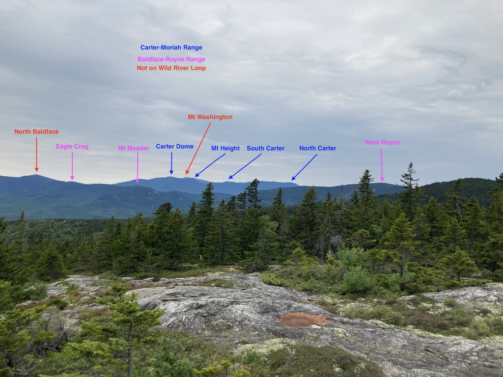
Charlie Tillett provides below a more comprehensive & updated route description (plus a photo from Speckled Mountain that shows some of the peaks on the Presidential, Carter-Moriah, and Baldface-Royce ridges). Note that the the High Water Trail mentioned above is now unusable.
Wild River Wilderness Loops
Take a run on the wild side and circumnavigate the 24,000-acre Wild River Wilderness Area which was carved out of the eastern edge of the White Mountain National Forest near the NH/Maine border in 2006. While not as quite as picturesque as the more popular Pemigewasset Loop (~30 miles with 9,500’ elevation gain), both Wild River Loops - short (~29 miles & 7,900’) and long (~34 miles & 9,300’) – offer many spectacular views and are formidable challenges.
Ten miles of the loops follow the Carter-Moriah ridgeline (tracking the AT over six 4,000’ peaks: Mt Lethe, North, Middle, & South Carter, Mt Height, and Carter Dome – plus Mt Moriah at 3,980’) which provides many vistas of Mt Washington & the Presidential range to the west and the Baldfaces / Royces to the east. But wait, there’s more! You also have three miles (or six on the long loop) along the Baldface-Royce ridgeline taking you over Eagle Crag and Mt Meader (plus West Royce at 3,166’ on the long loop). If you follow a counter-clockwise loop, this ridgeline gives you a great perspective to appreciate the impressive scope of the Carter-Moriah Range you traversed earlier in the day.
But if you enjoy “me time”, don’t discount the fun you’ll have during 10+ miles that take you into the heart of the wilderness area between these two ridges. Because the main access to these trails is via the dead-end Wild River Rd, you will find true remoteness here and will see few, if any, hikers. But this positive is also a slight negative as the southernmost trails (Rainbow Trail, Wild River Trail, and Eagle Link Trail) get quite overgrown due to the lack of foot traffic. Be aware that there is no blazing in the wilderness area but, if you take your time when the underbrush gets thick, it’s relatively easy to stay on-trail.
LOOP DESCRIPTION
The original trail description included the High Water Trail but, due to flood damage, this trail requires extensive bushwhacking so I have removed it from the my route writeup. On the other hand, everyone who has posted an FKT has taken the 1/10th mile detour to reach the Mt Moriah summit, so I include it as part of the route.
While these loops can be run in either direction, counter-clockwise has you going uphill on the steepest sections on the Carter-Moriah ridgeline and has been the direction used by all FKT attempts to date.
This CCW description starts/ends at the Shelburne trailhead. If you are doing the short loop, I suggest starting at the Wild River Campground and running ¾ mile down the Wild River Road to the Shelburne Trailhead. If you are doing the long loop course, I suggest starting at the Burnt Mill River Trailhead and running 2 miles up the Wild River Road to the same Shelburne Trailhead.
From the Shelburne trailhead, you run a couple hundred yards to reach the Wild River. The trail brings you to a very steep drop-off, but a gentler entry can be accessed from an obvious side trail heading to your right. The river here is quite wide with few steppingstones and must be forded (see notes below on water levels). Once you get across, head back left (upstream) along the riverbank to locate the trail which has a very small sign. You join a narrow, overgrown, and meandering trail section, crossing a very small brook and then Bull Brook before rejoining the original trail (which will be obvious once you see it). While only 1/3 of a mile long, this poorly marked section is the hardest part of the entire loop to follow (especially if you start in the dark) so scope it out in advance if possible.
·https://www.alltrails.com/explore/map/ccw-long-from-burnt-mill-ae50220
·Shelburne Trail from trailhead at Wild River Road
·Kenduskeag Trail
·Carter-Moriah Trail (backtrack 1/10th mile to visit Mt Moriah summit)
·Optional ¼ mile water detour on Imp Campsite Trail
·Rainbow Trail
·Wild River Trail (good water at junction with East Branch Trail)
·Eagle Link Trail (OK water at 2 brook crossings)
·Meader Ridge Trail
·Basin Rim Trail THEN:
For the SHORT loop:
·Basin Trail (from Rim Junction to Wild River Campground)
·Down Wild River Road to
·Shelburne Trailhead
For the LONG loop
·Continue on Basin Rim Trail (to West Royce summit)
·Royce Trail
·Burnt Mill Brook Trail
·Up Wild River Road to
·Shelburne Trailhead
Driving Directions:
Access to the loop is via the 5-mile Wild River Road (gravel) off Rt 113 near the intersection with Rt 2 in Gilead ME (Google: Wild River Campground which is in Jackson NH). There is parking all along this road including a large lot at both the Burnt Mill River Trailhead and the Basin Trailhead (at the Wild River Campground – where there is a toilet) as well as limited parking at the Shelburne Trailhead.
Water Considerations:
Water Levels:
There is no bridge over the Wild River so a ford of the river on the Shelburne Trail is required. You can track water levels on the Wild River (at Gilead ME) on the US Geological Survey website (link below). A reading of 2.5 feet or less makes for a very easy fording. The water can rise quickly after a rainstorm and, while I can’t offer any advice about how high is too high, I have seen the gauge raise from 2 feet to 6 feet over a 12-hour period during heavy rains. You also cross the Wild River and various brooks further upstream but these should not be an issue if you are able to cross the Wild River at the Shelburne Trail.
·https://nwis.waterdata.usgs.gov/me/nwis/uv?site_no=01054200
·https://nwis.waterdata.usgs.gov
Drinking Water:
Another consideration is drinking water. In addition to start of the Shelburne Trail, you cross the Wild River two more times (on the Wild River Trail near the East Branch Trail junction and on the Eagle Link Trail) and cross an unnamed brook with reliable water on the Eagle Link Trail as you head towards Eagle Crag. If you are willing to take a ¼ mile detour, there is also reliable water at the Imp Campground (off Carter-Moriah Trail near Imp Mountain).
Comments
I, Joffrey Peters will attempt to set a new FKT on the "short" Wild River Loop on Saturday, 2018-07-28. I intend to start and finish at the Wild River Campground, and will run the loop CCW. I will also include Mt. Height, because it's super cool, and why would you go up there and not tag it? The view is awesome!
The weather looks pretty crummy, but it's the day I have, so it'll have to do. I will track it with my GPS watch for verification, and try to stop to take occasional photos if it isn't raining too hard.
I did the loop - it's super burly. Kudos to anyone who has done this, it's a serious endeavor!
Here's a link to the loop on caltopo: https://caltopo.com/m/BM0C
Caltopo reports the loop as 27.5 mi, 7970 ft of gain. My Garmin put me at 29.8 miles (with a few missed turns, some bushwhacking, etc), and 8520 ft of gain.
I think the Highwater Trail is done for - future loops should probably take the Wild River Rd. to the Shelburn trail. That will make it a little faster, but also means the route doesn't intentionally include a bushwhack.
I did the Long Loop yesterday, including Mt Height, GPS is here: https://strava.app.link/iS6RutQVTsb
Completed time of 11:32:45, 33.63 miles.
The section along the Wild River is pretty thick, and muddy. The final climb up West Royce is tough.
As far as I can tell, this is an FKT, but would be surprised if this is true.