The 6-10 Trail is a popular route for runners, hikers, and bikers because of it history both locally and national impact. Bikers are only allowed on a portion of it. This trail is part of the Trans Allegheny Trail System. More information can be found at https://www.transalleghenytrails.com/. This gem is a mixed bag of rail trail and dirt trail. It does have some good elevation to it. There is a lot of history tied to this trail. There is even a museum at the one end of the trail with alot of great history. There is also one significant road crossing so be careful people do fly on down it, its on the museum side of the trail about a half mile from the museum, which is a national museum and is called the Allegheny Portage Railroad National Historic Site Visitors Center. There are placards along the trail giving the history of the area and some old features are still able to be seen along the trail.
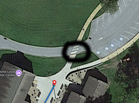
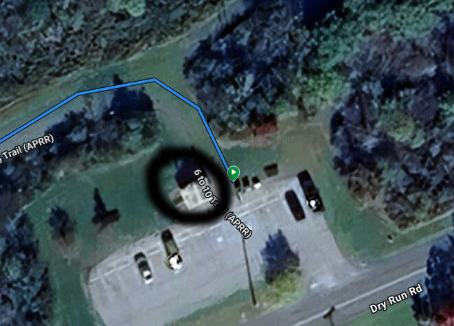
The In the attached pictures you will see two pictures with black circles. That is your starting/stopping points. The one is at the museum end, start/stop where the road meets the visitor center cement where the three dashes cross the road, have one foot touch the edge to start/stop. The other starting/stopping point is at the dry run road trailhead. Have a hand on the restroom to signify your starting/stopping point. Those are easy enough markers to start/end.
The one-way variant is the uphill going from The Dry Rd parking toward the NW. The out-and-back variant can be done from either end.
From Websites:
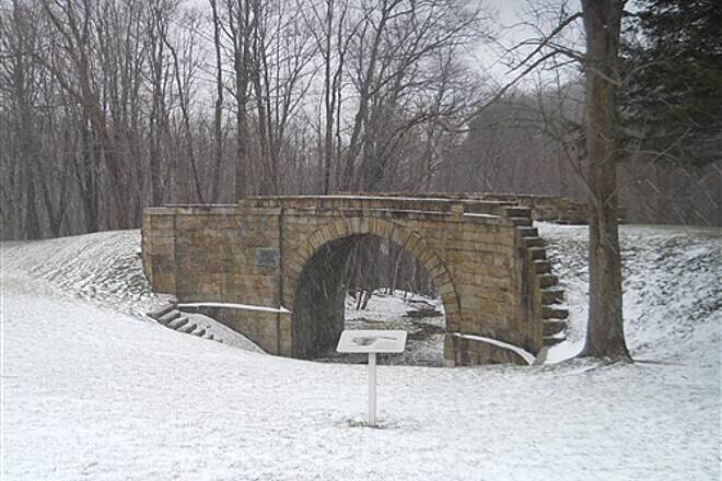
Today, the 7.5-mile route between inclines 6 and 10 has been converted into a rail trail featuring both hiking and biking sections, with historical culverts (drainage structures) visible along the hiking-only route. The trail makes up a small part of the September 11th National Memorial Trail that connects the 9/11, Flight 93, and Pentagon Memorials.
Be aware that the biking portion of the trail contains steep grades and poor sight lines, and while it is wheelchair accessible, the Valley Forge Road crossing is not. State game land surrounds much of the trail (both hiking and biking sections), and users are advised to wear bright colors to alert hunters year-round, particularly in the fall. The trail and parking areas are open from sunrise to sunset.
About the Route
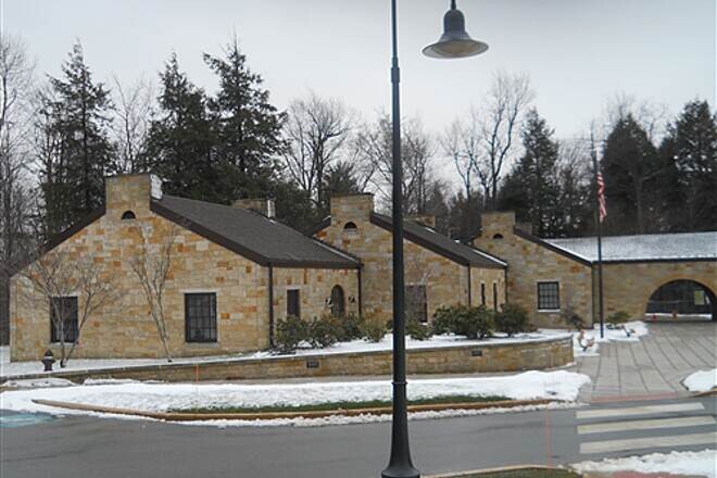
Leaving from the north end of the trail at the top of the mountain, where the National Park Service maintains a visitor center at the Allegheny Portage Railroad National Historic Site dedicated to the history of the railway, as well as restrooms, drinking fountains, and picnic areas. At the summit is a reproduction of an engine that lifted the train cars and a re-creation of the steep tracks of incline 6, as well as a tavern restored to its 1840s appearance. These buildings are open daily (9 a.m.–5 p.m.) in spring, summer, and fall, and weekends only in winter. This area also provides access to a hiking-only trail heading westward, the Summit Level Trail.
From the visitor center, trail users can tackle the 6 to 10 Trail as it heads east and downhill along the path of the Allegheny Portage Railroad; this twisting section is a steep and tricky descent recommended for capable hikers. Loops and spurs offer opportunities to extend the mileage a bit and to see additional historical artifacts. Bicycles are not allowed on this portion of the trail, so bikers will start about 3.3 miles farther along the route at the Muleshoe trailhead and follow the path of the railroad that supplanted the portage system.
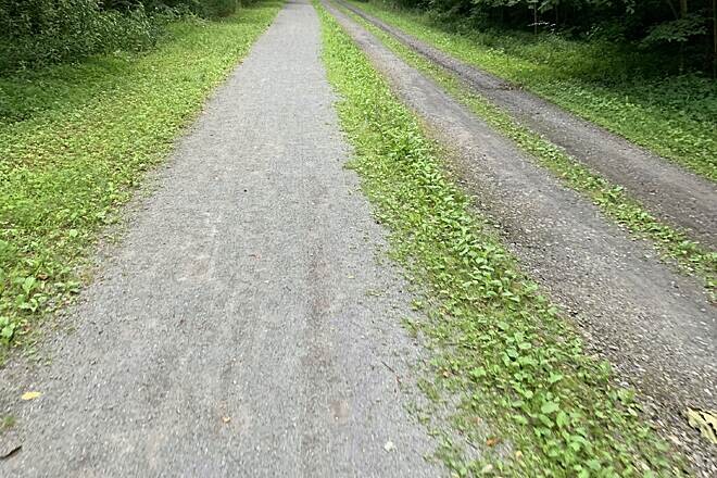
From the Muleshoe trailhead, the trail rolls about 4.2 miles downhill on limestone dust to the Dry Run Road trailhead, where restrooms and water fountains are available. Look for wildlife such as white-tailed deer, turkeys, pheasants, and chipmunks, as well as snakes and the occasional black bear. About halfway along this segment, the route comes to another 1.2-mile hiking-only segment that extends past two historical culverts and then reconnects with the trail just southeast of Valley Forge Road and a third historical culvert.
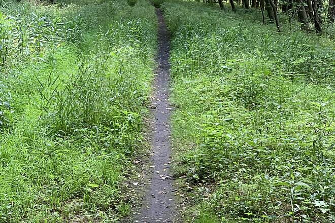
As the trail nears the southeast trailhead at Dry Run Road, it connects with the 1.6-mile Foot of Ten Trail, a hiking-only, somewhat triangular loop that extends northeast toward the former site of an engine house and another historical culvert, after which it heads south (on a partially overgrown path) toward the Dry Run Road trailhead. The southernmost quarter-mile of the 6 to 10 Trail, leading to the trailhead, shares the same path as the southwest side of the Foot of Ten Trail loop.
Trail History
Spurred by the success of New York’s revolutionary Erie Canal, Pennsylvania started constructing its own canal system in 1826 to link Pittsburgh and Philadelphia. But the Allegheny Mountains complicated Pennsylvania’s task.
In the years it took to establish Pennsylvania’s canal system on either side of the Alleghenies, trains were coming into use. Forward-thinking engineers looked to these machines to traverse the final 40 miles of rugged terrain, but the primitive locomotives couldn’t manage the mountain slopes. Pennsylvania’s solution was the Allegheny Portage Railroad, a complex system that saw entire canal boats transferred from canals onto trains that, much like the canals themselves, ran over more or less level ground before coming to an elevation change. At each steep incline, the locomotive would be disconnected and its line of cars hoisted up the slope by a stationary steam engine at the top. The train cars would be connected to a new locomotive and transported to the next incline, where the process would be repeated. On the downhill side, the same machinery controlled the train cars’ descent.
Ten such inclines brought canal boats and other cargo up and over the Alleghenies between Johnstown and Hollidaysburg—five each on the eastern and western slopes of the range. Once the barges had been portaged across the mountains, they were returned to canals to finish their journeys. It was a massive undertaking that reduced travel time between Philadelphia and Pittsburgh from about 23 days to just under 4. Officially opening in 1834, the system would run only for a little more than two decades before more powerful locomotives rendered it obsolete.
Parking and Trail Access
The 6 to 10 Trail System runs between Summit Level Visitors Center (Duncansville) and 390-404 Valley Forge Rd. (Duncansville), with parking available at both ends.
Comments
Hi Dean, on Saturday November 1st I'll be attempting to best the unsupported FKT you set out and back. Thanks for getting the 6 to 10 added as an FKT route.