Location
Oregon,
US
Distance
4.8 mi
Vertical Gain
3,900 ft
Description
GPS Track
Mcloughlin_.gpx154.99 KB
FKTs
Male
Female
| Max King | 1h 0m 18s | ||||
| Josh Nelson | 1h 2m 58s |
Images
This route on the old FKT site
Comments
I am planning on climbing Mt McLoughlin tomorrow morning. There is no posted female unsupported time on this site; however, there is a strava segment where the fastest female time is 1:39. My goal is sub-2 hours. I do not know if previous athletes on strava ran solo, had support etc. so I am tossing my name out here!
That ain't no "shield volcano" dude, hence why it is steep...
Turns out you are both right.
"McLoughlin is a stratovolcano, made up of basaltic andesite on top of underlying basaltic andesitic shield volcanoes."
http://volcano.oregonstate.edu/mcloughlin
I am going to take a shot at the Mcloughlin summit record tomorrow, Sunday Aug 16th. The record has been lowered though. Max King ran it yesterday, Strava shows 1:00:18 for the segment, not sure what his actual time was, but I'll ask him before I go to do it so I don't have any surprises. I'd say my odds of beating his time a pretty low, but you never know until you try.
ended up doing it on Monday. new baby at home right now, not sleeping the best, so I thought why not push it back a day. Felt fine here today, just not very fast. Though really it's not like it was that slow either. 1:07:29 on the strava segment, 1:07:53 on the full climb. Not that close, but I do think that it's at least possible for me to get this down to 1 hour, though not super likely.
Route name: Mt Mcloughlin Picnic Triathlon
Location: US: OR
Distance: 97 mi (multi-sport)
Vertical gain: 9600 ft
Description:
This route was not accepted as an official FKT because it does not meet the 50% on foot rule, which is fine, but I thought I would still add it on here in the comments here as inspiration for any multi-sport enthusiasts out surfing FKT routes. Buzz, Peter, and regional editors will continue to not accept triathlon style efforts unless they very much meet the 50% rule and make aesthetic/logical sense. If you try this and best my time feel free to add a “reply” to this comment linking your GPS data!
Whether done casually or competitively, Picnic triathlons are meant to be a fun, motivating way to experience the outdoors by blending mixed-sport skills with nature. I encourage anyone to give this a go as a goal to finish in under 24 hours! If you Southern Oregon/Nor Cal triathletes have been looking for an excuse to get up Mt. McLoughlin...HERE IT IS!!! (for those based in Ashland/Medford, I think it is fair game to make a variation that starts from Ashland up Dead Indian Memorial or travel over to take me down on this)
A little about the places and "Picnic" triathlons:
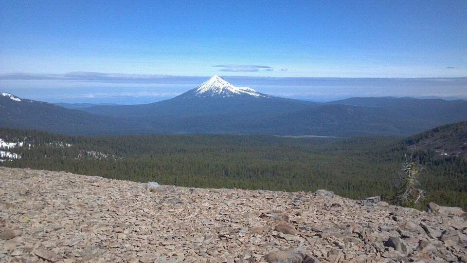
Mount McLoughlin is a steep-sided stratovolcano, or composite volcano, in the Cascade Range of southern Oregon and within the Sky Lakes Wilderness. It is one of the volcanic peaks in the Cascade Volcanic Arc, within the High Cascades sector (wikipedia). Standing at 9,495' above sea level, It is also the tallest peak in Southern Oregon (AllTrails). As a prominent peak, it does have a history of speed efforts even having both ascent and circumnavigation FKTs.
Lake of the Woods is a beautiful and rare high mountain lake. Lake of the Woods is one of just a few natural lakes in Southern Oregon suitable for multi use recreation. Fortunate not to be on the reservoir system, our water level only fluctuates a 1-2 feet per year. While it is ultilized for motorized recreation, it is very suitable for recreational swimming.
I had been staring at these two on a map for quite some time, thinking they were perfect for a human-powered "Picnic" style (bike-swim-mountain run-swim-bike) triathlon, like that of the famed Yosemite Picnic and the Grand Teton Picnic. Being back in Klamath Falls for the teaching year, and during the West Coast Fire Apocalypse that was September 2020, with every other option seemingly closed or full of smoke, I decided it was time to bring this fun, human-powered adventure to life.
In short, “picnic triathlon” efforts are usually bike, then swim, then run a mountain and back down, then swim back, then bike back. The efforts usually also start from a town or hub so as to be conducive to completely human-powered, unsupported execution. (though supported and self-supported are acceptable too for the record boards here)
The Stats:
The Route (play-by-play):
Enjoy food at:
Rodeos Pizza - amazing bottled beer selection, some of the best pizza you will ever have (closes at 9 in summer, 8 in winter)
The Pikey - Good Burger selection, and bar fare (usually serving food until 2am) *hours adjusted currently (Sept 2020) due to COVID (10pm)
My own experience:
I went in complete unsupported fashion in a time of 11hrs, 46min, 59sec
(photos in Strava links below) Here is an IG Stories Highlight Reel of the adventure.
Bike 1 - starting just after 7:34am - 38.75 miles in 2:09:21
Swim 1 - in 57:09
Up & down Mcloughlin - 15.89 miles in 4:08:35
Swim 2 - in 54:46
Bike 2 - finishing at 7:21pm - 38.75 miles in 2:00:59
I think that this effort could easily see times under the 10 hour mark, eventually seeing sub-9s.
By Jason Hardrath (STRAVA, IG or FB)
I am hoping to attempt an FKT on 10/3/25