Location
Ohio,
US
Description
39.4312558, -82.5386443
FKTs
Male
| Ian Koenig | 35d 8h 46m 0s |
| Josh Horsfall | 38d 5h 4m 0s | ||||
| Everett Brandt | 55d 6h 12m 0s |
Images
Comments
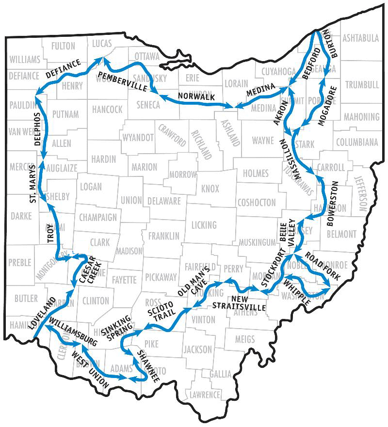
To my knowledge Andy “Captain Blue” Niekamp’s 88 day hike is the fastest time for the full trail. I will be starting my attempt June 12, 2018 at the Akron/Bedford/Medina junction in the Cleveland Metroparks' Brecksville Reservation and head south on the Akron Section. I will continue south through the Massilon section and will leave Belle Valley at Map Point 25 to circle the 145.2 mile Wilderness Loop clockwise through Road Fork, Whipple, and Stockport Sections back to Wolf Run State Park. Instead of repeating the 29.2 miles of the connector, I will shuttle/taxi back to the Stockport/Whipple intersection at Stockport Map Point 7 and continue west toward Hocking Hills State Park. After completing the Williamsburg section I will hike south on the 12.6 mile Loveland Spur to Eden Park overlooking the Ohio River in Cincinnati. I will shuttle back to Loveland Map Point 9 in Milford and continue north around the state. After finishing the Medina Section where I started I will continue north to Lake Erie at Headlands Beach State Park and complete the 257 mile “Little Loop.” I will end my trek at Massilon Map Point 11 where it meets with the southern terminus of the Akron Section. I have an In-Reach tracker which posts to: https://share.garmin.com/EverettBrandt. I hope to be able to post pictures on the trail to Instagram, username: everett_brandt Instead of PO drop, I will have family meet up with me every two or three days to resupply pre-packaged food, clothing, etc.
I will be beginning an FKT attempt of the Buckeye Trail being today, 9/27/21. I'll be beginning my hike at Akron section point 31 and heading north to complete the little loop in a clockwise direction. Upon finishing the loop I plan to continue south to Belle Valley section point 25, where I will turn east to complete the loop in a clockwise direction. Upon completion of the loop I'll arrange transportation from Belle Valley section point 25 to Stockport section point 7, where I will continue west until I reach the southern terminus at Eden Park. Then I plan to again arrange transportation back to Williamsburg point 29/Loveland point 9 where will continue north until I complete the entirety of the Buckeye Trail at Akron section point 1/ Bedford section point 1. I will be tracking my hike using a Garmin Fenix 3 smartwatch, trying to upload my progress daily or as my cell phone reception allows.
I’ll be starting my supported FKT attempt of the Buckeye Trail on November 28th south of the town Wellington. I will start near the end of Norwalk section point 24 and Medina point 1 at the disc golf parking area. This is mile 951.9 on Guthook/Far Out if you have the settings on Southbound for direction. I will be heading counterclockwise to finish at the same point. I will be doing the trail supported as much as possible so when I get to the loop areas hopefully I will be able to arrange a ride with a friend but if not I will just double back and do some bonus miles. I’ll be tracking my route using a garmin in reach. I will try to be doing daily updates on my Instagram @naturalhorsepower
I hope you give it another go.
I'll be starting my FKT attempt of the Buckeye Trail on 10/20/22 at the Bedford Reservation at MM 897.8 heading counter-clockwise. My goal is 42 miles per day, and I will be doing it supported (that darned Southern Loop). I have no arranged support apart from a ride to the trail, so I'll technically be self-support until something changes, but if I can arrange something, I wont hesitate to do so. I'll be uploading on Garmin (In-Reach Mini & New-Fangled Smartwatch if I get it running), Strava, and you can reach me on my Instagram 70LBHammerisoutside.
Update: I'm changing my start location to the corner of SOM Center Blvd. and Hawthorn Pkwy at Bedford MM 877.2. Garmin Mapshare is share.garmin.com/XXZSH
I will start my self-supported FKT attempt of the Buckeye Trail on June 1st. I will be starting from Shawnee State Park off mile 1220.5 in the Shawnee section and hiking the loop counter-clockwise. I plan to hike the connecting sections of the loops twice as well as hiking the leg to the southern terminus in Eden Park twice. I will be using a Garmin InReach for tracking and my MapShare can be found at https://share.garmin.com/heathergoes. I will also post updates to my Instagram @heather.goes
I will be starting a self-supported FKT attempt of the Buckeye Trail on 8/19/24. I will be beginning at Massillon Section Point 11 and head counterclockwise on The Little Loop before continuing South to Belle Valley Section Point 25. I will complete The Wilderness Loop counterclockwise and return to Belle Valley Section Point 25. I am currently waiting for a response as to if I am allowed to hitchhike from Belle Valley Point 25 down to Stockport Section Point 7 since the attempt will be self-supported. If I am unable to get a hitch, or the FKT Team decides that is not allowed in a self-supported run, I will re-hike the section. I plan to then continue the BT clockwise to Williamsburg Section Point 29 to Eden Park where I will again attempt a hitch (or re-hike). Upon returning to Williamsburg Section Point 29, I will continue clockwise to my end point, Bedford Section Point 1.
I will be tracking my hike using a Garmin Instinct 2 Solar and updating my progress daily to Garmin and Strava. I will also be posting updates on my Instagram @koenigian. You can find me on Strava or Garmin by searching my name "Ian Koenig"
I will begin my supported FKT attempt of the Buckeye Trail on 6/15/2025 at around 6:00am. I will be beginning at Eden Park Loveland section point 1 and run towards the Main Trail and begin clockwise from Loveland Section Point 9 in Milford. Once I get to the Little Loop, I will run that clockwise from the Three Way Junction of Medina. Once I finish the Little Loop upon returning to the Three Way Junction, I will get a ride back down to Massillon Section Point 11. I will then head south to Belle Valley and get a ride to Stockport Section Point 7. From there I will run the Wilderness Loop counterclockwise to return to Stockport and from there finish the Main Trail going clockwise back to Loveland Section Point 9 in Milford.
I will be tracking my run using my Coros Pace 3 and updating my progress daily to Strava under my account Caleb Kennelly as cell service allows.