Route: Glacier Point, Yosemite (CA)

Location
California, US
Distance
4.6 mi
Vertical Gain
3,200 ft
Description

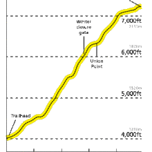
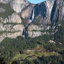
Glacier Point is a popular view point above Yosemite Valley. It can be accessed by car, or via the Four Mile Trail, which gains 3200' in 4.8 miles from the floor of Yosemite Valley. This trail roughly follows the route of an old toll trail that was completed in 1872.

There hasn't been a lot of FKT activity reported for the Four Mile Trail. On his speed climbing site, Bill Wright claimed the FKT at 1h9m (no date given), and attributed the women's FKT of 1h31m51s to "Rebecca" (Oct. 1999, "with medium pack").

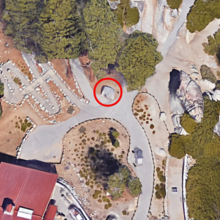
The Four Mile Trail ascent route begins at the Four Mile Trailhead (where pavement turns to dirt), and ends at a small boulder at the top of the final set of stairs, just NE of the Gift Shop (see photo). This route now has a Strava segment. But note that Strava can be off by many seconds, so it's best to post your actual time here. Additionally, the Strava segment ends about 0.1 miles below the top of the Four Mile Trail, which must be reached to claim the FKT ascent.

Another option (submitted by Rory Beyer) is the old Ledge Trail:

The Ledge Trail is the shortest route between Yosemite Valley and Glacier Point, cutting along the otherwise sheer granite cliffs behind Curry Village. The historic trail was abandoned decades ago due to dangerous conditions and several deaths (as detailed in "Off the Ledge: Death in Yosemite."), however, remnants of old Park Service painted markings, signs, and granite steps remain scattered throughout the route. 

The route begins directly behind Curry Village. After climbing up through wooded areas, you will eventually reach the Glacier Point wall, at which point you begin angling up and right along a wider-than-expected ledge that runs ~2/3 of the way up to the valley rim. Here, an obvious, slightly overgrown gully cuts up and left, taking you all the way to the rim. You can then continue upward to join the 4-mile trail, or cut straight to Glacier Point – you've done it!  The ascent from Curry Village is about 2.3 miles. Descend via the Four Mile Trail and run back to your starting point for an excellent tour.

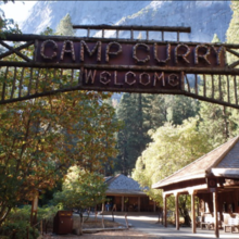
  • For the ascent FKT, the start point is the large wooden "Camp Curry Welcome" sign (see photo), located just west of the Curry Village Pizza Deck. From here, head straight south towards the massive Glacier Point wall, and begin your ascent up through wooded area. 
  • For the RT: At the base of the Four Mile trail, turn right and run the ~2 miles back to Curry Village along the Valley Loop Trail. After about a mile, the Valley Loop Trail begins paralleling the bike path.  You must follow the Loop Trail - not the road.
GPS Track
Images

Comments

User Picture
Profile picture for user tocsa

Why isn't this has a descent portion as well, just like the Half Dome FKT has an ascent and a descent?

While he did not exactly run the exact ascent route, Strava user "Bertrand" ripped up to Glacier Point in an effort that would clock a time of ~42 minutes for this route. Taken from his huge day out here:

https://www.strava.com/activities/9301285720/overview


I will be attempting to submit the first official Women's FKT record for the Four Mile Trail Up & Down route tomorrow (7/29/2024) with a goal time of sub 1hr 50min. My time and track will be recorded using a GPS watch and Strava.Â