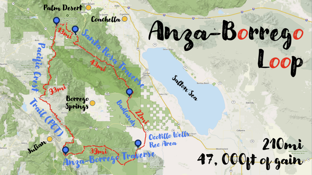
The 210mi Anza-Borrego Loop elegantly combines two established FKT routes, the Santa Rosa Traverse and the Anza-Borrego Traverse, a section of the Pacific Crest Trail (PCT), a section in the Jacinto Mountains Monument, and a traverse of the Borrego Badlands into one big, fabulous, irresistible, unforgettable 210mi loop. You will simply get to see the very best of the Anza-Borrego desert region.
The route has a total of about 47,000ft of elevation gain. The high point is Toro peak (8,717ft), the highest peak in the Santa Rosa mountains. The low point, just barely above sea level, is located at the eastmost point of the route in the Ocotillo Wells State Vehicular Recreation Area.
The Santa Rosa Traverse alone is considered very difficult, the Anza-Borrego Traverse is no joke either. Part of the difficulty is the lack of water on most of the loop. Besides a bit of raw endurance, one will need a variety of other crucial skills to be successful on this adventure.
Public access to Toro peak (8,717ft) has waxed and waned over the years, it seems. The peak lies on the Santa Rosa Indian Reservation and is full of telecommunication equipment and cameras. It is not entirely clear what the current public access status is and whether it is enforced or not. You will find many guidebooks and reports that do not mention any public access issues.
However, Toro has a neighboring peak that is unofficially called Wind Chill Peak (33.524081, -116.4292). It sits quite literally next to Toro's main peak and tops out at 8,600ft (117ft less than Toro). Toro’s official West peak is a little further away and sits at 8,316ft. The Sierra Club’s Hundred Peak Section website lists the new Toro summit registry location on Toro’s West peak (33.527132, -116.435755).
For this FKT route, I suggest that competitors either summit the unofficial Wind Chill Peak (33.524081, -116.4292), or, as an alternative, Toro’s West peak (33.527132, -116.435755). Access to these peaks require off-trail travel, so, despite the slightly lower summit elevations, I argue that this requires a similar effort than climbing Toro peak along the road.
Because Toro’s North Peak is 717ft lower than the Toro's main peak, it should not count for this FKT route.
Pics, reports, and more info about the Santa Rosa Traverse and the Anza-Borrego Traverse can be found on their FKT pages:
More info, tracks, and maps about the loop at https://www.christofteuscher.com/anza-borrego-loop
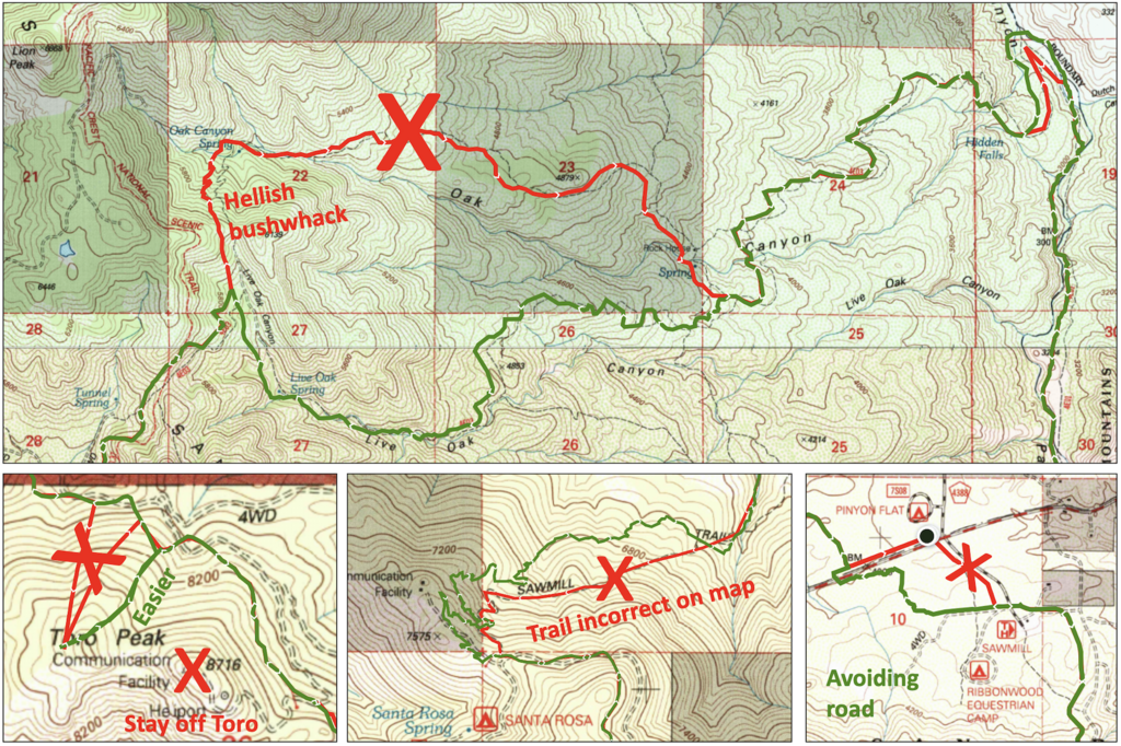
Apr 21, 2023: Minor route updates. See updated GPS track as well as additional image with details of changes.

Comments
The first attempt was an epic failure:
Slight route updates coming soon. Check back!
2nd attempt! https://www.christofteuscher.com/aagaa/news-2nd-210mi-anza-borrego-loop-attempt