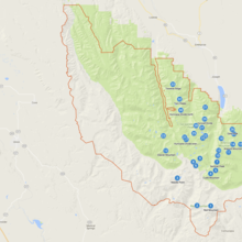
The Eagle's 33 Challenge consists in summiting all 33 peaks over 9,000ft (2743m) with at least 300ft (91m) of prominence in Oregon's Eagle Cap Wilderness. You can choose your own route between the summits. Most practical routes are likely going to be over 100mi with at least 60,000 feet of vertical gain. There is no time limit. More info and list of all peaks: http://www.christofteuscher.com/aagaa/eagles-33-challenge
| Latitude |
Longitude |
Elevation [ft] |
Prominence [ft] |
Peak |
| 45.245 |
-117.2929 |
9838 |
6386 |
Sacajawea Peak |
| 45.2278 |
-117.2992 |
9832 |
337 |
Matterhorn |
| 45.2597 |
-117.2654 |
9781 |
893 |
Hurwall Divide |
| 45.203 |
-117.175 |
9702 |
2101 |
Aneroid Mountain |
| 45.1894 |
-117.2203 |
9675 |
1253 |
Petes Point |
| 45.3043 |
-117.3448 |
9673 |
1974 |
Twin Peaks |
| 45.2862 |
-117.2632 |
9628 |
808 |
Chief Joseph Mountain |
| 45.2796 |
-117.3412 |
9621 |
487 |
Hurricane Divide north |
| 45.1637 |
-117.3014 |
9575 |
1221 |
Eagle Cap |
| 45.0648 |
-117.2458 |
9572 |
2004 |
Red Mountain |
| 45.1373 |
-117.2462 |
9518 |
889 |
Cusick Mountain |
| 45.2405 |
-117.2734 |
9508 |
418 |
Hurwal Divide south |
| 45.1551 |
-117.2935 |
9499 |
327 |
Glacier Peak |
| 45.2262 |
-117.1715 |
9460 |
650 |
Hidden Peak |
| 45.1634 |
-117.226 |
9417 |
559 |
Sentinel Peak |
| 45.1776 |
-117.2236 |
9395 |
473 |
Polaris Point |
| 45.219 |
-117.3293 |
9388 |
852 |
Hurricane Divide south |
| 45.2368 |
-117.1771 |
9384 |
408 |
East Peak |
| 45.2169 |
-117.2713 |
9317 |
383 |
Peak (S of Ice Lk) |
| 45.2138 |
-117.3241 |
9287 |
309 |
Hurricane Divide even more south (CT) |
| 45.2223 |
-117.3968 |
9233 |
1855 |
Elkhorn Mountain |
| 45.2221 |
-117.2627 |
9215 |
519 |
Craig Mountain |
| 45.1888 |
-117.3888 |
9180 |
863 |
Glacier Mountain |
| 45.2165 |
-117.2123 |
9179 |
527 |
Mount Bonneville (W Fk/E Fk Wallowa divide) |
| 45.1445 |
-117.2302 |
9171 |
342 |
Peak (Mid Fk Imnaha) |
| 45.2187 |
-117.135 |
9137 |
546 |
Peak (McCully, CT) |
| 45.2031 |
-117.1505 |
9130 |
332 |
Mount Melissa (McCully/ Little Sheep divide) |
| 45.1851 |
-117.1888 |
9105 |
614 |
Dollar Ridge (Eric's Peak) |
| 45.3376 |
-117.3667 |
9095 |
513 |
Traverse Ridge |
| 45.0654 |
-117.2894 |
9093 |
1255 |
Krag Peak |
| 45.2047 |
-117.1382 |
9023 |
329 |
Mount Melissa Due (CT) |
| 45.1715 |
-117.2802 |
9019 |
481 |
Pocket Peak (CT) |
| 45.1274 |
-117.3522 |
9018 |
1467 |
Needle Point |
To qualify for the winter variation, the effort must take place between December 21st and March 20th. A winter attempt is a much more committing, to an already committing endeavor since uphill travel time will exceed downhill travel time, and skis or snowshoes are welcome tools to complete this challenge.


Comments
On Sat, Aug 8, 2020 @ 3am, I will start for a 3rd attempt at summiting all 33 peaks over 9,000ft in Oregon’s Eagle Cap Wilderness in a single push.
Dotwatching: https://bit.ly/Eagles33III
More info at https://www.christofteuscher.com/aagaa/news-3rd-eagles-33-peak-bagging-fkt-attempt
The 3rd Eagle’s 33 Challenge attempt ended in yet another failure: it took me a whopping 110h 17min (4d 14h 17min) to bag 32 peaks. For a totally inexplicable reason, I’m now going back for a 4th attempt with a new strategy and a new route. Planned start: Wed, Sep 2, 2020.
Dotwatching: http://bit.ly/Eagles33IV
More info at https://www.christofteuscher.com/aagaa/news-4th-eagles-33-peak-bagging-fkt-attempt
If someone is to attempt the "winter" variation of this please check the Wallowa Avalanche Center before going out.