Route: Fox River Trail (IL)

Location
Illinois, US
Distance
38 mi
Vertical Gain
800 ft
Description

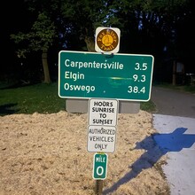
This rail trail connects Algonquin and Oswego along both banks of the Fox River. The majority of the trail is paved, with a handful of miles of crushed limestone. In a few locations, the trail follows a road for brief sections, and these are generally well marked. The trail connects to other trails at both ends. The north terminus is clearly marked with a "mile 0" sign (pictured on this page). The south terminus is not clearly marked; for the purposes of this FKT, it is a small circle on the trail just south of the bridge over Waubonsee Creek in Hudson Crossing Park. These endpoints are reflected in the GPX on this page.

GPS Track
Images