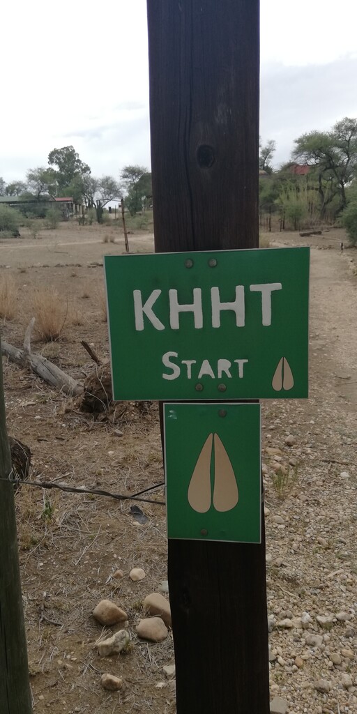
http://www.landscapesnamibia.org/windhoek-green-belt/sites/default/files/KHHT_flyer.pdf
There is a 90km option (normally done in 6 days), and a 55km option (normally done in 4 days). These are described below.
90km Route: (2300m gain)
Day 1 : from Duesternbrook Safari Guest Farm to Otjiseva Campsite. 16 km "tough day"
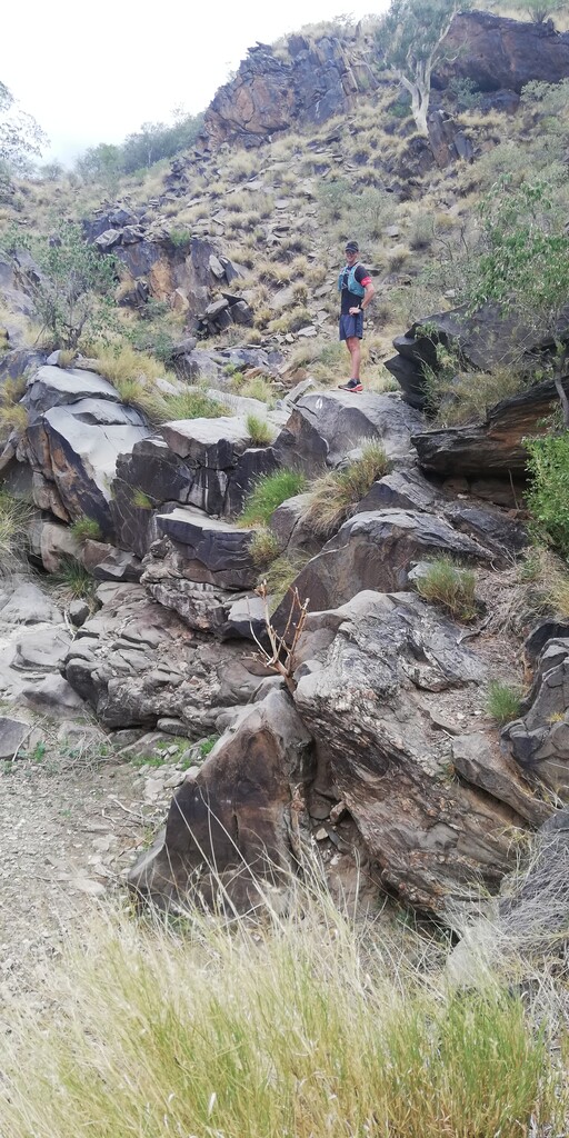
The trail starts at the Guest Farm Düsternbrook, follows the Otjiseva River for about 1.5 km. Than you turn left out of the river, follow the signs towards the main entrance gate of Duesternbrook. Now you enter Otjiseva farm. You follow the main road for a short while about 700 m and than the turn out to your right onto the track ( signposted) which leads again to the Otjiseva river passing UNDER THE BIG TREES, RIVER/GAME WATCH WALK and GEMSBOKKOELTE before turning into the mountains. The vegetation is of the Bosveld type and the often large trees provide lots of shady places to rest, for instance under the BIG FIG TREE REST, where we had lunch – near 12km. The owner of the farm showed us rock engravings at KLIPMERK GATE. The meaning of these engravings is still unknown. We rested a lot on rocks in the river bed. The path leads along some narrow kloofs with some interesting rocky waterfalls – one too high to climb and a path was made up a hill and around it. From the top of the mountain - at the TOKTOKKIE TRACK REST- we had impressive views of the surrounding hills and flatter countryside looking towards Windhoek. A last an easy climb leads to the beautiful setting of the overnight stop GUSTAV POSTEN, still on the farm Otjiseva, next to a big dry dam. It is completely in the wilderness and the sounds of Africa’s wild animals are heard and game seen, without having to be quietly. Some interesting signs boards are SEXY FIG TREE, THE-ROCK-UNDER-THE-ROCK, SIT-GAT-RUS-BENE.
Day 2 : Otjiseva to Onduno Campsite (9 km) "relax"
We follow again a riverbed on the KLIPPEKOU KLIM uphill until we reach the border with the farm Onduno before the SLAGYSTERKLIP gorge. We sit a while on the rocks at the RED ROCK LIZARD REST waterfall and spend some time at the PARTRIDGE POOL and watch lots of birds coming to drink water. At a farm dam, with water for a large number of cattle, we are met by the owner of this farm. He explains to us the route downhill into another riverbed with Oryx, Kudu, wonderful flowers and trees, past the CREEPY CORNER. We have lunch at the side of a farm road under some shady bushes at the top of a hill where there is a nice breeze - this is experienced at higher spots on the trail. Then up a hill to YIPPIE ON TOP ...!! Early in the afternoon we arrive at the next overnight place - also next to a dam - where we have enough time to explore the surroundings and observe the bird and animal life. The camp is below the LOOK UP!! BABOON MOUNTAIN, on the bank of a small dry river in between two rocky hills with steep kranses. The one hill is called Bobbejaan kop - obviously a baboon sleeping place
Day 3: Onduno to Godeis Campsite (23 km) "tough day"
On this day we cover the longest distance of 23km. It start by going up and down on hills and grassland areas, with small bush and beautiful vistas, where we see lots of gemsbok, kudu and zebra, passing KOELTE BOOM and DEATH IN THE RIVER. After crossing the corner border to Godies, at 6km and climbing the SCORPION HILL we reach ZEBRABAD and cross over into two valleys with a beautiful long valley down BIRD NEST GORGE, where leopard tracks leads us down to the lunch spot in the Middagrivier at 10km. A 4 m long python lying in the sun in a rocky area before the DEATH VALLEY gives us exiting moments. We follow this long bigger dry river, for about 3km, with very high cliffs past BIG HANGING CLIFFS and the MENSVRETERGROT to the COMPRESSOR REST. In the ROOIKAT KLOOF a steep climb and crossing at 16km takes us to another valley past the TWIN ALOE AT A WATER SLIDE and LAST WATER. Just before we reach our next overnight place we have to climb up and down rocks in the narrow impressive LOVEBIRD GORGE. We saw and heard the Rosy-faced Lovebird that breeds here, but we also had a close encounter with a 3 meter long Black Mamba. Just before sunset we meet with Ursel, the owner of Godeis, with beers for our sun downer drink, on the Sun downer hill above the overnight camp, to watch a beautiful sunset scene as the sun go down behind the many mountains of the Khomas Hochland.
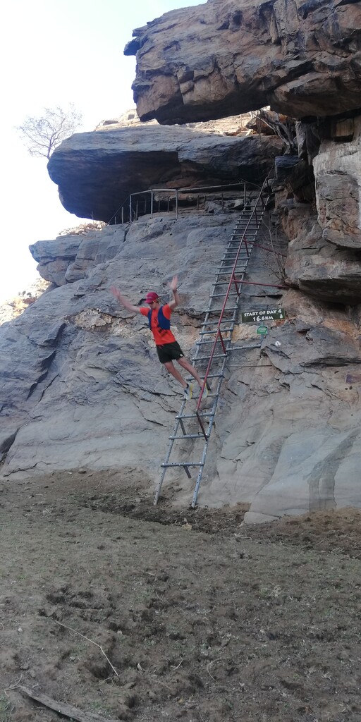
Day 4: Godeis back to Onduno Campsite but on a different trail (16 km) "is is ok"
We leave our overnight place again through the LOVEBIRD GORGE, past GATKRAP BOOM and turn right into the Otjompaue river, which forms a wide valley. Passing the PIEPIE VALLE and the GROOT KAMEELDORINGBOOM EN SY KLIP BALLE, which brings us to the Onduno Farm border and the VEGTENDE BULLE PUT. The BABOON BAR gorge is something special. We see many, unfortunately dry dams and a number of San places one at BUSHMAN/SAN PLACE. After the ZEBA PEEK HILL, GOGGA OPDRAANDE you can have lunch at BLOW WIND BLOW - GIGGLE REST. We passed KAALGAT RANTE and STONE SIT to a point, where we rested for the last time and looked at the Onduno homestead at ANKE’S HOUSE VIEW. Then down to the big dam with lots of water and the CROAK DRINKING PLACE. Suddenly we were back at our Day 2 overnight camp. We had excellent weather on our whole trip, sometimes even a bit too warm, but during this night the thermometer fell to about 5°C.
Day 5: Onduno to Monte Christo Tree House (17 km) "tough day"
Each day brings interesting vistas and so did this day not disappoint! We had a pleasant hike past LEKKER SWIMMING, THROUGH THE BEAUTIFUL BUSHES up on GRANDPA’S PATH, past KIEKIE DAM to the WINDHOEK REST. Windhoek city can clearly be seen in the distance. We TAKE IT SLOW BUT GO on THODO’S PATH through GAT SKEUR DEUR DRAAD to the highest point at 360⁰ AND OH SO FAR FAR AWAY!! with the best views all round of the whole trail, seeing as far as Okahandja and Windhoek while resting a round hill just under 2000 m above sea level.
After we have done some ups and downs past HEAVEN REST, BERND’S MOUNTAIN REST and ENORMOUS COCOON CORNER, we crossed the border to Monte Christo Farm on LEVEL ON THE GRAVEL to the WATERFALL. We climbed down this breathtaking high waterfall with 5 well secured wooden ladders. We pass KORT-PAD-LANG-PAD, with a well deserved rest at SEER-KNIE-DAMRUS and walking past the STEENBOKKIE PLEK we finally reach the Aretaragas River at TARENTAALDRIF. Breathtaking hiking for a kilometre along this river, watching hundreds of water birds and plenty of game pass SO CLOSE, we come to the Tree House, our overnight place on this farm. This tree house is a 3-storey building, built around and in a massive big Ana tree, with double decked 5 star toilets, a lookout and braai area on the first floor, overlooking a dam constructed round the tree. This was very special.
We took a walk to the Monte Christo home. It has a number of small lakes, which is ideal for bird watching such as water birds and Fish eagles. In total on this hike we identified more than 50 species of birds. We saw many oryx, waterbuck, springbok, zebra, kudu, warthogs and other small mammals.
Day 6 : Monte Christo back to Duesternbrook Farm (14 km) "relax"
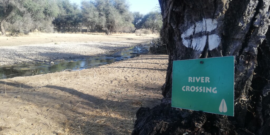
The last day of the KHHT is a pleasant walk along the Otjiseva River with a number of river crossings and passing the following markers DRIE-ANA-BOME-RUS, COOL TREE REST, VLAKVARKGATE, WATERVOëLS LOOP and WATER KLIPPE. This day led us from Monte Christo via Otjiseva back to the starting point at Düsternbrook.
55km Route: (1200m gain)
Day 1 : Duesternbrook to Otjiseva Campsite (16 km).
The trail starts at the Guest Farm Düsternbrook, follows the Otjiseva River for about 1.5 km, than you leave the river and follow the markings to the main entrance gate of Duesternbrook. Now you enter Otjiseva Farm, follow the signs a bit on the main road for about 700 m and than you turm right on to the signposted trail. Soon you will be passing UNDER THE BIG TREES, RIVER/GAME WATCH WALK and GEMSBOKKOELTE before turning into the mountains. The vegetation is of the bushland savanah, the often large trees provide lots of shady places to rest, for instance under the BIG FIG TREE REST, where we had lunch – near 12km. The owner of the farm showed us rock engravings at KLIPMERK GATE. The meaning of these engravings is still unknown. We rested a lot on rocks in the river bed. The path leads along some narrow kloofs with some interesting rocky waterfalls – one too high to climb and a path was made up a hill and around it. From the top of the mountain - at the TOKTOKKIE TRACK REST- we had impressive views of the surrounding hills and flatter countryside looking towards Windhoek. A last an easy climb leads to the beautiful setting of the overnight stop GUSTAV POSTEN, still on the farm Otjiseva, next to a big dry dam. It is completely in the wilderness and the sounds of Africa’s wild animals are heard and game seen, without having to be quietly. Some interesting signs boards are SEXY FIG TREE, THE-ROCK-UNDER-THE-ROCK, SIT-GAT-RUS-BENE.
Day 2 : Otjiseva to Onduno Campsite (9 km)
We follow again a riverbed on the KLIPPEKOU KLIM uphill until we reach the border with the farm Onduno before the SLAGYSTERKLIP gorge. We sit a while on the rocks at the RED ROCK LIZARD REST waterfall and spend some time at the PARTRIDGE POOL and watch lots of birds coming to drink water. At a farm dam, with water for a large number of cattle, we are met by the owner of this farm. He explains to us the route downhill into another riverbed with Oryx, Kudu, wonderful flowers and trees, past the CREEPY CORNER. We have lunch at the side of a farm road under some shady bushes at the top of a hill where there is a nice breeze - this is experienced at higher spots on the trail. Then up a hill to YIPPIE ON TOP ...!! Early in the afternoon we arrive at the next overnight place - also next to a dam - where we have enough time to explore the surroundings and observe the bird and animal life. The camp is below the LOOK UP!! BABOON MOUNTAIN, on the bank of a small dry river in between two rocky hills with steep kranses. The one hill is called Bobbejaan kop - obviously a baboon sleeping place.
Day 3 : Onduno to Monte Christo Tree House (16 km)
Each day brings interesting vistas and so did this day not disappoint! We had a pleasant hike past LEKKER SWIMMING, THROUGH THE BEAUTIFUL BUSHES up on GRANDPA’S PATH, past KIEKIE DAM to the WINDHOEK REST. Windhoek city can clearly be seen in the distance. We TAKE IT SLOW BUT GO on THODO’S PATH through GAT SKEUR DEUR DRAAD to the highest point at 360⁰ AND OH SO FAR FAR AWAY!! with the best views all round of the whole trail, seeing as far as Okahandja and Windhoek while resting a round hill just under 2000 m above sea level.
After we have done some ups and downs past HEAVEN REST, BERND’S MOUNTAIN REST and ENORMOUS COCOON CORNER, we crossed the border to Monte Christo Farm on LEVEL ON THE GRAVEL to the WATERFALL. We climbed down this breathtaking high waterfall with 5 well secured wooden ladders. We pass KORT-PAD-LANG-PAD, with a well deserved rest at SEER-KNIE-DAMRUS and walking past the STEENBOKKIE PLEK we finally reach the Aretaragas River at TARENTAALDRIF. Breathtaking hiking for a kilometre along this river, watching hundreds of water birds and plenty of game pass SO CLOSE, we come to the Tree House, our overnight place on this farm. This tree house is a 3-storey building, built around and in a massive big Ana tree, with double decked 5 star toilets, a lookout and braai area on the first floor, overlooking a dam constructed round the tree. This was very special.
We took a walk to the Monte Christo home. It has a number of small lakes, which is ideal for bird watching such as water birds and Fish eagles. In total on this hike we identified more than 50 species of birds. We saw many oryx, waterbuck, springbok, zebra, kudu, warthogs and other small mammals.
Day 4: Monte Christo back to Duesternbrook Safari Guest Farm (14 km)
The last day of the KHHT is a pleasant walk along the Otjiseva River with a number of river crossings and passing the following markers DRIE-ANA-BOME-RUS, COOL TREE REST, VLAKVARKGATE, WATERVOëLS LOOP and WATER KLIPPE. This day led us from Monte Christo via Otjiseva back to the starting point at Düsternbrook.