Lava Beds National Monument is renown among cavers, with miles upon miles of explorable lava tubes. All this to say...You’re going to need a headlamp and a helmet because you’re going to be underground for about 7,090’, or in other words 1.34 miles.
Obviously, we recommend rehearsing the caves sections before the real effort, you can get lost. Use a helmet please! You can split your head open.
This is a 16 mile, South to North traverse of Lava Beds National Monument, incorporating the best point-to-point, “moderately hard” caves in the monument.
We spent a great deal of time researching which caves linked into one another, without getting overly small or rough for efficient travel.
The established start is at the Southern boundary (at the large sign on Forest Road 44N75) of Lava Beds National Monument, due to its elevation being about 1150’ than the Northern terminus at Lyons Trailhead.
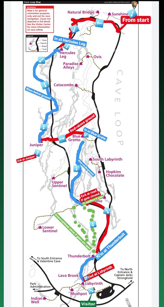
After your starting photo with the sign:
- Run for about ~1 mile on road 44N75, it is your choice where you break off the road as the next section to the “Cave Loop” is a bushwhack. We left pants and helmets for caving at our turn off point.
- Bushwhack for ~1 mile, navigating your way to the southernmost curve of the “Cave Loop” paved road
- Turn right (counter-clockwise) onto the Cave Loop and follow this road until the Hercules Leg cave entrance there is an obvious sign, you are now going underground for the 1,948’ of Hercules Leg and the 2,362’ of Juniper
- You will emerge from the Juniper Cave entrance and go for a short stretch on trail before bushwhacking across the center of the loop, including finding your way across a collapsed lava tube, to the Blue Grotto entrance
- Down into the Blue Grotto follow it as it merges into South Labyrinth for about another 3,700’ underground before the cave emerges at the Cave Loop Road
- Cross over the road, here you have a choice, if the gates are open at the south end of Thunderbolt you can continue underground, or you can follow the Cave Loop Road to the Thunderbolt entrance and dive down connecting the north portion of Thunderbolt into the 1,239’ of Labyrinth and exit from the Labyrinth Exit.
- From the Labyrinth exit follow the trail past the visitors center, we created a gear cache behind a tree near here, as from here you will be above ground.
- Merge onto the trail down to the campground from the corner of the visitors center lot, follow until the campground
- Once in the campground look for the “Bunchgrass Trail” follow this out of the campground
- At the merge, Take a right onto Missing Link Trail, Follow this until it connects you with Lyons Road
- Right onto Lyons Road until it terminates at the Southern trailhead of Lyons Trail
- Now just run the 8.2 mile Lyons Trail to its Northern Trailhead
- Stop the Time as you tag the Gate!!!
I know, seems confusing but between the maps, GPX file, and rehearsing the caves...you will very much enjoy this route :)
Cave Routefinding Resources:
http://caves.org/grotto/sag/content/newsletter/LavaBeds.pdf
Submitted by Trevor Rokosky, Lynne Caikoski, Ashly Winchester, and Jason Hardrath:
http://www.npshistory.com/brochures/labe/caves.pdf
See color-coded cave Route Photo
https://www.nps.gov/labe/planyourvisit/upload/LAVA%20BEDS%20CAVES.pdf
Comments
After completing the one-way S-N FKT 2020-06-08, I returned to the starting point for an OKT for the OAB route. I returned by the same route of 30.28 mi in a total time of 7h:26m:19s. **Please take special note of appropriate cave routes to follow in order to legally and safely traverse the park during seasonal closures for bat habitation.**
https://www.strava.com/activities/3585872250/overview