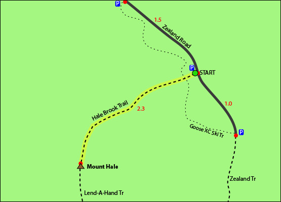
The shortest trail up to the summit of Mount Hale is the Hale Brook Trail. Mount Hale is considered one of the easiest hikes out of all the 4,000 footers. It is a short 2.2 mile hike to the summit, and a relatively straight path. This is not one of the more popular 4,000 footers because of it's very limited summit views. The summit is basically an open circle field with a big cairn (rock pile, usually a summit indicator) in the center, surrounded by trees. There is evidence of a fire tower that used to be there. Your best bet to see any views is to climb up the cairn and look out, but even then, the views are limited.
Mount Hale is easily accessed from Zealand Road in the summer, making for an easy 4.6 mile hike. Unfortunately Zealand Road was still closed as of April 28, so we had to summit from the other side using an unofficial trail called Fire Warden's Trail. We took a little more time than usual trip planning because we would be navigating with marked blazes or signs. Using the official White Mountains Guide map , we marked our parking spot at Little River Road to Mount Hale. The instructions are as follows:
- Park at the end of Little River Road
- Take the bridge behind you across Little River
- Take a left at the bridge and follow the river until you hit Haystack Road (1 km)
- Once on the paved Haystack Road, turn left until you reach the marked North Twin Trailhead
- Follow North Twin Trailhead, until you reach Little River. DO NOT CROSS. (~1 km)
- Instead, keep walking upstream, keeping the river on your right. You'll cross a tiny stream a few hundred yards after the "do not cross" point
- Soon after you will hit a tree in the middle of the trail with 2 axe marks, marking the beginning of Fire Warden's Trail
Once you're on Fire Warden's Trail, your path is relatively straight forward. Even though the trail is unofficial, there is a good amount of foot traffic that makes the trail easier to follow. We followed the streams of running water up towards the peak. We ran into snow for the last mile until we reached the (obstructed) view of Mount Hale. Snowshoes might have been helpful for a few sections here, but there were so many falling snow bridges 4-5 inches thick that I'm not sure snowshoes would have prevented you from post holing anyway. It was all soft snow so spikes or crampons weren't super useful either. Welcome to spring hiking! From there, we had lunch and came back the way we came for a quick descent!