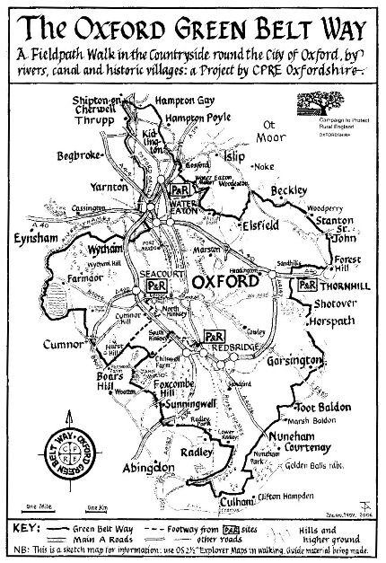
Location
United Kingdom
Distance
87.6 km
Vertical Gain
716 m
Description
GPS Track
Oxford Green Belt Way.gpx185.47 KB
FKTs
Male
Female
| Harry Geddes | 7h 49m 25s | ||||
| Paul Fernandez | 8h 34m 43s | ||||
| Simon Ross | 11h 34m 41s |
| Jason Smith | 8h 46m 19s |
| Lyuba Bozhilova | 13h 6m 14s |
| Maria Ordovas-Montanes | 17h 51m 1s |
Images
Comments
Off to start this now unsupported. Weather looks good for an autumn day. I'm sure the rain yesterday will have left a few sticky fields in places. Hopefully 10-11 hours with a successful report to follow!
Great run Simon! I ran this route (supported) last year so will submit that to make a pair!
Great run Jason. I thought somewhere 8-9 hours was probably doable. If I was being picky maybe that three years of planning should have found the right route! :)
For future greenbelters lots of online sources for this show your route through Woodeaton but this is incorrect and confirmed on signposts on the ground. It’s probably the worst part of the route as well made up of ploughed fields. Might need to call yours. the ‘Woodeaton variation’.
I’m sure those extra 3km would have taken you at least three hours leaving me with the fastest time! Something to aim for. Well done
Thanks! On the 'Woodeaton variation', up until 2019 I was exploring the 'standard' book route, which is a bit of a nightmare in places along the Cherwell. Then that route became completely impassable just before Sescut Farm where a tree had fallen and damaged a bridge, and the online map swiftly changed to the Woodeaton route, so I switched. It's better in some ways but has a nasty stretch of road coming out of Woodeaton and you miss going through Elsfield and the view coming back down the hill. From what you say it sounds like the bridge is now fixed and we're back to the original route?
Note that the route Jason took seems to be about 1.5 miles shorter than the original (standard) route.
Going to have a go at this tomorrow, unsupported. Hoping to get around before it gets too dark and muddy!
It did get dark and muddy, but managed to get round in 8 hours 34 mins. Full report to follow....
I'm going to have a go at this tomorrow, unsupported. Hoping it's not too muddy or windy after today's weather.
I have had May 28th on my calendar since mid-September.... tomorrow's the day!! The preparations have already been a great journey and hoping to celebrate by putting everything together. Will be receiving support at 'aid stations' from friends. Have a re-route planned due to National Grid project around Marsh Baldon but very similar terrain and distance to the posted route.
The story of what happened after my FKT: https://www.outtherepodcast.com/episodes/fkt
On Sunday (21st July) I'll be running this unsupported. It will be at the same time as the OxBelt relay event, but I will not be running with the relay runners, and I will be running straight through the changeover points without accepting any aid. I will not be running with a tracker because the 15 available trackers are for the 15 relay teams. The marshal at each changeover point will note down my split times and I will submit the GPX file from my watch. The only diversions I anticipate will be to run a bit further along the Thames Path after Wytham Woods to avoid an overgrown section, and to take a slightly different path across the fields afterwards. Any others I will declare after my run. My goal is around 9 hours 30 mins which would take a significant chunk off the current female supported record.
Unfortunately yesterday's attempt was unsuccessful. I made it to Cumnor (25 miles) but I was unable to continue because I could not keep food down since before Radley (17 miles) and my energy levels decreased significantly. Afterwards I found out I also had severe dehydration despite drinking 2.5-3 litres of water during the 25 miles. It was the right decision to stop, and I do not know whether I will make a second attempt in another spring or summer.
How bad can the heat be? Attempting this tomorrow, clockwise, starting from Thornhill P&R. I will be going self-supported to make sure I can get enough water en-route, and hopefully for a cheeky Calippo from the corner shop in Wolvercote. I don't expect any diversions aside from small deviations due to farm work, in particular around Forest Hill.
Success! A little slower than I had hoped, at around 13h6m, but I'm still reasonably pleased with myself. I took some voice notes along the way, and I'm looking forward to doing a more comprehensive report down the line.