On Friday, October 9, 2020, I set out to create a route/attain an FKT/OKT/new route connecting each of the 10 named canyons within the boundaries of the Colorado National Monument.
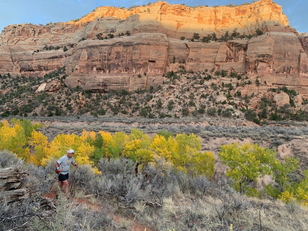
The Colorado National Monument lies in western Colorado just south of Grand Junction and Fruita. It consists of 20,500 acres of deep sandstone canyons and monoliths along the Colorado Plateau. The area was officially established as Colorado National Monument on May 24, 1911 after John Otto spent years of research and development in preserving this as a national monument.
I have spent two years piecing a route together for this journey. While it is not incredibly long (roughly 40 miles) it was surprisingly difficult to find a way to connect each of the canyons using trails and off-road. While an FKT on this route would be nice to accomplish, I am most interested in the future journeys that others would be attracted to and helping them research routes that suit their needs.
My route was:
- Start at Kodel’s Trailhead located on Highway 340 across from the Fruita Rodeo Complex. Kodels (K1) trail to Fruita Dugway; 0.5 miles and 50’ el. gain
- Fruita Dugway Trail to Black Ridge Trail; 2 miles and 1027’ el. Gain This segment traverses Kodels, Fruita and Lizard Canyons.
- Black Ridge Trail to CCC Trail; 3 miles and 900’ el. Gain
- CCC Trail to Monument Trail, crossing Rim Rock Drive in CNM. 0.75 miles and 0’ el. Gain
- Monument Trail to Wedding Canyon; 6 miles and 200’ el. Gain This segment checks off Monument Canyon passing by Coke Ovens, Kissing Couple and Independence Monument.
- Wedding Canyon Trail to base of Monument Canyon Trail. 2 miles and 0’ elevation gain As the name implies, this checks off Wedding Canyon
- Monument Trail to Fence-line and over to Gold Star Trailhead. 2 miles and 100’ el. Gain Where Monument Trail turns away from the fence line toward Independence Monument and away from the buffalo fence, there are social trails that travel along the CNM boundary to Gold Star.
- travel up Gold Star Canyon Trail to Bench Trail. This is a steep 1000’ climb in 1 mile and traverses Gold Star Canyon.
- From Bench Trail follow a social trail to Otto’s Staircase and climb the stairs to the overlook. 0.5 miles and 500’ el. Gain Early in the development of CNM, John Otto carved these steps, allowing us to navigate this steep canyon wall. There is no special equipment needed but a helmet and rope may come in handy to those trying it for the first time. The trails leading to this climb are faint and there are many social trail options. Once you start to climb, keep an eye open for cairns marking the route to the stairs and along the rock ledge.
- From the top of Otto’s Stairs travel west, without trail for 0.3 miles to the Monument Canyon wall below. Follow this rock ledge for approx. 0.75 miles. This will lead you to Otto’s Bathtub; a rock formation that is super fun to explore by itself. Beware leaving the cliff edge too soon as it provides travel without disrupting the cryptobiotic soil. You will see Otto’s Bathtub and when you are at a right 90-degree angle from the formation it is safe to travel to the bathtub. While there are still spots of protected soil, the terrain consists mainly of deep sand and sagebrush. The easiest way to get on top of Otto’s Bathtub is to climb the northern-most end. However, I have found other undisclosed areas of this formation where John Otto carved additional steps. These areas are very fragile and hold great historic value so it is safest to make the climb on the northern point.
- Travel along Otto’s Bathtub and over to Upper Liberty Cap Trail 1 mile and 50’ elevation gain
- Take a right turn onto Upper Liberty Cap Trail toward Black Ridge. Follow the well-marked trail it’s terminus at Rim Rock Drive. 5 miles and 750’ elevation gain
- From the trailhead, turn left and run along the paved road for 2 miles to Ute Canyon Trailhead.
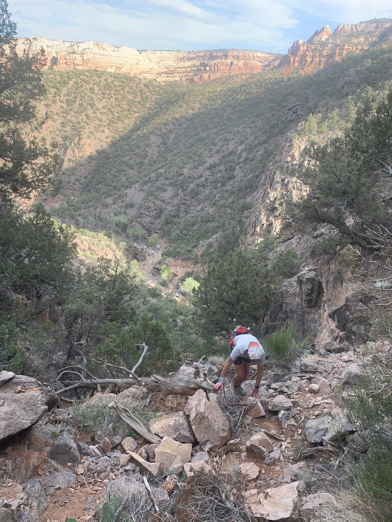
- Climb down Ute Canyon Trail into Ute Canyon and follow the sometimes faint/overgrown trail for approx. 5 miles. Elevation gain on this segment is roughly 500’
- Near the intersection with Ute Canyon Trail and Corkscrew Trail there is a social trail that goes east. This unnamed trail leads through Columbus and Red Canyons over 4 miles and 1200’ elevation gain. This trail passes by a historic water pump house and some amazing rock formations and ends near the east entrance to CNM and multi-opportunity trailhead.
- From the trailhead climb No Thoroughfare Canyon. While the first two miles of this trail are marked fairly well, the upper 5 are more route-finding than trail. Total distance 7 miles and 2000’ elevation gain. This will check off the tenth and final CNM canyon, No Thoroughfare Canyon.
Total distance = 38.9 miles
Total estimated elevation gain = 7096
Editor's note (3/12/25): New route variation to differentiate between route direction
Comments
Nice one. Love the creativity! I'm sure others will be inspired to try this out for themselves.
Thanks Johnny D!! It is a beautiful route. It doesn't matter how many times I've run each of the segments, I always see something new to explore. It is a great place to play in the back yard
Hey Matt! My friends and I have done so many segments of this but have been chicken to do Otto's staircase to the top... it would be such an awesome connector so we can't stop wondering what it's like on the last part above the carved stairs... tricky? We plan to only go up and then run over to LIberty Cap not the opposite way thanks for any intel! We are strictly trail runners NOT climbers.... so ... thanks!
hi Paige,
so sorry for the late reply. I’ve checked in a few times but for some reason I didn’t see your post until today. The staircase is definitely more of a mental barrier than physical. The stairs are fairly close to one another and easily navigated. There is a metal post at the bottom of the stairs. Once you prop yourself up on that post you are pretty much committed to going up. I hope you are able to make your run route. It’s one of my favorite sections for sure.
Planning on giving this a go tomorrow. Solo and unsupported starting at No Thoroughfare and ending with the dugway descent. Tracking on SPOT here: https://maps.findmespot.com/s/VXZX
It's going to be a spicy one but I'm planning on running the 10 Canyon on Saturday (05/08). Will be putting a bike at the end and riding back to my car unless one of you F-Boyz or anyone else wants to give me a ride back. Gonna be something :)
Ended up getting a late start so just a little recce/hike in the monument today... going to have to save the whole thing for another day.
This is an amazing route and it is N to S, and not S to N. I don't agree that S to N efforts belong in the same FKT. It takes a very different effort to complete it N to S vs. S to N.
Here is the comparison:
S to N is 4832ft gain and all the steep sections are downhill and all the uphill sections are nice trails
N to S is 7118ft gain and all the steep sections and all the bushwhack sections are uphill
Very big difference in resistance without even counting elevation gain.
Even if you ignore all the steep sections and bushwack parts, there is still a 2300ft elevation gain difference!
It's like if you run Mt Elbert FKT downhill and claim the same respect as the person who ran it uphill.
It's just simply not fair to compare N to S efforts against much easier S to N.
Tomas - I agree about the difficulty difference depending on the direction taken. Many FKT traverses have directional delineations and perhaps that would be appropriate here. My approach when running this route was to select the most aesthetic/enjoyable line and a net downhill with enjoyable bushwhacking sounded great. For reference, several notable FKT traverses are net-downhill affairs including the Bryce Canyon Traverse, Joshua Tree Traverse, Tenmile Traverse, and Boulder Skyline Traverse. This route can undoubtedly go faster in either direction, especially self-supported or fully supported. Get it!
I attempted this route South to North today ( April 7, 2024) and completed it in 9:12:16 ( pending submission) but wanted to share a few thoughts in these comments for others who choose to attempt this! This is such an incredibly cool route!
Firstly, My apologies for not noting my intentions of attempting this route beforehand, as I understand that is the respectful thing to do. I was running into issues with FKT, and was unable to get logged in (likely my fault, not FKT) until I got it open on my laptop. However, I do apologize for not being forward of my intentions, and would like to note that I have so much respect for all athletes who have attempted or completed this burly route! Now to a few notes:
The elevation profile posted at the top of this page seems to be a bit off, as I recorded 7,750 feet of ascent instead of just over 7k as stated above. I also noticed that Natalie had a similar vert profile as I recorded! So note that it will likely be closer to 8k as opposed to 7k vert.
The one short bushwacking section between the top of the stairs and the bathtub does seem to have a really faint trail that avoids the cryptobiotic soil, but can be difficult to hold onto. The best way to find it is to directly cross the top of the bluff once you reach the very top of the staircase section, then hold onto a few sections of slickrock before you see the faint trail to the left.
I noticed some comments about directional delineations for this route, and I would like to add that I agree that a deviation might be in order to give this route the depth for FKT community potential it deserves, in addition to giving Giff Walters record the credit it deserves as a very different experience! I was thinking about it, and I believe this record N to S would have very specific difficulties, for example descending the waterfall scrambles, in addition to descending Ottos stairs- which would likely be quite a heady decent 25 ish miles in. There are a few more places that would require very intense downhill travel as well; so it makes sense to consider expanding this route on this website; as I can only imagine the wild difference in experience!
Based on the previous conversations within this thread, there should definitely be a delineation between N to S versus S to N but should not take away from efforts put forth on either direction. I personally feel that this only makes sense. So maybe there should be two separate directional routes created for this FKT to avoid there being any miscommunication on times. Giff currently holds the unsupported FKT but technically not for the route given on this main page. Although stated that he was travelling S to N, there DOES need to be a delineation, again, in my opinion. With this said, I am hoping to give a go on this route on Saturday March 8th, 2025. I will be attempting this FKT N to S as, based on this main FKT page, the route is intended. Have not decided whether I will attempt a supported push or unsupported yet but will give further details as I get closer to the start date. Hopefully my opinion of this route is not too controversial.
Going for a push this morning around 7 a.m. self-supported. Headed N to S
Going N to S, unsupported starting at 6am!