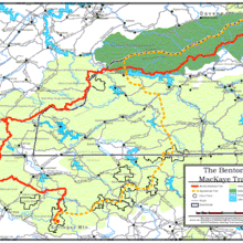
The Benton MacKaye Trail is a relatively new route that opened on July 16, 2005. It runs 288 miles from Springer Mountain, GA (also the southern terminous of the Appalachian Trail), to Big Creek in the Great Smoky Mountains National Park. The trail was created by the Benton MacKaye Trail Association.
Here's a larger pdf map of the BMT: http://www.bmta.org/pdfs/BMT-OverviewMap.pdf
Great Smoky Mtns NP: (93 miles / 18,500 ft elevation gain) This route traverses a portion of the nearly 300 mile Benton MacKaye Trail (BMT) within the Great Smoky Mountains National Park (phrased as BMT-S for purposes of this FKT description). The route starts in the Big Creek Area of the Park (at the Baxter Creek Trailhead), follows the yellow BMT designated route on the Great Smoky Mountains National Park official trail map, and ends after exiting the Lakeshore Trail and reaching the park boundary just north of the crossing over Fontana Dam. The route starts and ends in the same locations of the park as another very popular FKT route, the S.C.A.R (Smokies Crossing Adventure Run). The BMT-S is nearly 25 miles further than the SCAR and has slightly more elevation gain. The following scenic trails (or portions of trails) make up the BMT in the park: Baxter Creek, Mount Sterling, Mount Sterling Ridge, Balsam Mtn, Beech Gap I and II, Hyatt Ridge, Enloe Creek, Chasteen Creek, Bradley Fork, Benton MacKeye Connector Trail, Newton Bald, Thomas Divide, Sunkota Ridge, Martins Gap, Deep Creek, Pole Road Creek, Noland Creek, Lake View Drive (road from Noland Creek to Lakeshore Trail), Lakeshore Trail. Additional information on the BMT can be found on bmta.org.
Georgia: (81.8 miles / 15,000 ft elevation gain) Named for the original proposer of the Appalachian Trail, the BMT is essentially an "AT-alt" from Springer Mountain through the Smokies, following a more western route initially than the AT itself. The GA section of the AT has been a popular route recently; this section of the BMT is quite similar in total mileage, elevation, and beauty. It can likely be completed within 24 hours (or close to it), making it ideal for those seeking a long day out, rather than the multi-day experience required to finish the additional >200 miles of the full trail into TN and NC. Many Georgia ultra-runners are familiar with portions of the BMT from popular trail races including Cruel Jewel and the Georgia Death Race. This section extends from the trail's southern terminus on Springer Mountain (just ~0.2 miles downhill from the AT's southern terminus) to Double Spring Gap on the TN/GA state line. It is mostly trail, but includes a total of ~7 road miles.


Comments
https://share.garmin.com/TJBMT. Starting another south bound attempt Sunday at 5 am Eastern time 10/4/2020. Self supported.
This Friday (4/23) at noon I'll be attempting a supported Benton MacKaye FKT headed southbound. I'll be using a Spot Gen3 tracker as a primary tracker. I'll also record the whole journey via my Coros watch which I will upload to Strava after the attempt. I'll be sure to take lots of pictures and videos along the way which will be uploaded to my Facebook/ Instagram page to help verify my effort.
Tomorrow (July 24) I'll attempt to see how fast the GA section can be done, starting from the TN/GA state line around sunrise (supported).
Hello! Candy Mama here. Beginning October 3rd 2021 at midnight from Springer Mtn I will attempting to set the Fastest Known Time on the Benton MacKaye Trail going northbound. This will be a supported effort. I will be using my Suunto Ambit watch that is connected to my Strava account to track my attempt. Alongwith my watch I will also have my Spot Tracker. I will be posting on Instagram during my record attempt.
Strava - https://www.strava.com/athletes/29013353
Instagram -https://www.instagram.com/tara.dower/
Tomorrow (12/26/22) afternoon I will be attempting a southbound self-supported FKT. I will be posting daily on my Strava and Instagram along the way. I will also track the entire route with an InReach.
Strava: https://www.strava.com/athletes/35407928
Instagram: https://www.instagram.com/sky_bake/?hl=en
Live Tracking: https://share.garmin.com/KHGJT
Thursday (1/5/2023) I will be starting a northbound unsupported FKT attempt. I will be recording with my Garmin Instinct 2 solar watch and uploading the tracks to Strava as reception allows. I will also be taking lots of pictures and uploading some of them to Instagram.
Strava - https://www.strava.com/athletes/43064827
Instagram - @budhikes
Tuesday (8/29/23) afternoon I will be attempting a northbound self-supported FKT. I will be posting daily on my Strava and Instagram along the way. I will also track the entire route with an InReach.
Strava: https://www.strava.com/athletes/35407928
Instagram: @sky_bake https://www.instagram.com/sky_bake/?hl=en
Live Tracking: https://share.garmin.com/KHGJT
On Friday, 3/22 at 7am I'll be attempting a Southbound unsupported Fastest Known Time. I'll be tracking via Garmin inReach and my Coros watch. Will upload Strava tracks once completed. https://share.garmin.com/bstew
Happy Trails, Bob!!