The Great Western Trail in Illinois is a 30-mile multi-use trail that runs from Sycamore, IL at its western terminus to Villa Park, IL at its eastern terminus. It is divided into a Western Segment (17.5 miles) and an Eastern Segment (12.5 miles), which can be connected by surface roads (8 miles) for a total distance a bit longer than 38 miles. "The Great Western Trail crosses small streams and wetlands where duck, coot and the Great Blue Heron nest and raise their young. Shrubs, including Dogwood, Blackberry and Hazelnut mingle with the few remaining patches of native prairie. It is a place of quiet beauty, a linear wildlife refuge, and truly one of the finer experiences available in Kane County." (https://www.enjoyillinois.com/explore/listing/great-western-trail).
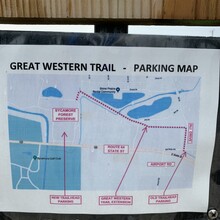
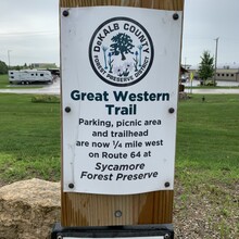
Start at the northeastern corner of the Sycamore Forest Preserve and follow the trail about 0.5 miles east to the old trailhead at Old State Rd. Then proceed 17 miles east on the crushed limestone trail to the St. Charles Trailhead, which has a picnic shelter and toilets. From there, head southeast on Dean St. to its intersection with 64/Main St. (1.3 miles) and turn left. Follow 64/Main St. east through historic downtown St. Charles and continue out past the DuPage Airport to the stoplight at Atlantic Dr. (5.6 miles) and turn right. Follow Atlantic Dr. to Shingle Oak Dr. (0.5 miles) and turn left. Take your first right off of Shingle Oak Dr. onto Sandcherry Ln. Take your first left off of Sandcherry Ln. onto Hemlock Ln. Take your first right off of Hemlock Ln. onto Sassafras Dr.
The entrance to the Eastern Segment of the Great Western Trail will appear on the left after being on Sassafras Dr. for 300 feet. Travel east on the Great Western Trail for 12.6 miles until you reach the Villa Park Trailhead and its twin brick pillars connected by a wrought iron sign reading "Great Western Trail" (see picture).


