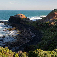
Route: Mornington Peninsula Walk

Location
Victoria, AU
Distance
97.5 km
Vertical Gain
1,500 m
Description

Mornington Peninsula Walk is a 97.5km, grade 3 Circuit hike located in Mornington Peninsula Victoria. The hike should take approximately 8-10 days to complete.
Long known as a destination with beautiful beach walks and spectacular clifftop strolls, the Mornington Peninsula boasts one of Victoria’s top walks.

The Mornington Peninsula Walk takes a roughly triangular route, linking four established trails and traversing the most beautiful and spectacular parts of the peninsula. Along the way, the trail takes in the historic fort at Point Nepean and the foreshores of Portsea, Sorrento, Blairgowrie, Rye, Rosebud and Dromana before climbing over Arthurs Seat and descending through lovely stretches of forest and ferny glens to the dark and brooding cliffs of Cape Schanck and the Lighthouse. From the Lighthouse, the track weaves its way west through thick coastal tea-tree and drops onto yellow-sand beaches before a final stretch of alternating tight single track and cliff-top trail brings you from Rye to London Bridge.

The 100km Mornington Peninsula Walk combines four other walks: the ‘Two Bays Walk‘ through the hinterland from Dromana to Cape Schanck, the ‘Coastal Walk’ through the Mornington Peninsula National Park along the Bass Strait coast from Cape Schanck to Portsea, the ‘Point Nepean Walk’ in and around the Point Nepean National Park, and the ‘Bay Trail’ from Portsea to Dromana along the shores of Port Phillip. You can complete the whole walk over several days, or enjoy it over several visits.

GPS Track
Images