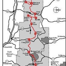
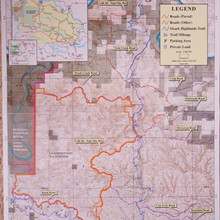
The Ozark Highlands Trail stretches 200+ miles through northwest Arkansas. It was built, and is maintained, by the Ozark Highlands Trail Association. Some beautiful photos from the trail are on this site. Like many regional trails, the OHT is in the process of being developed. To now the FKT route has been the 165 mile stretch from Lake Fort Smith to Woodlum, which is displayed on the map below. At present that could be extended another 15 miles to Tyler Bend/Hwy 65. From here the trail is in the process of being constructed, with a very small stretch in limbo with a private owner. Once that issue is resolved, which some suggest is very soon, the trail will extend to a continuous 208 miles. Beyond this is a gap with no built trail, and it seems likely there won't be a trail for some time. The OHT picks back up with the 31.6-mile Sylamore Section, from Spring Creek to Matney.
The Sylamore Section of the OHT is provided as a Variation. From Spring Creek Trailhead in Big Flat, AR to Matney Trailhead in Norfork, AR (Mile 222 to 253 or 0 to 31.6 on section maps. See U.S. Forest Service, Sylamore Ranger District, Mountain View, AR OHT Sylamore Section Recreation Opportunity Guide for topo and local information, or see Ozark Highlands Trail Guide late 4th edition or later by Tim Ernst. Jake Anderson describes it as follows: "This is the newest section of the Ozark Highlands Trail. Recent restoration projects have made this one of the best point to point routes in the Natural State. Challenging terrain combining forest/logging roads, large rock gardens, boulders, creek crossings and large climbs make this route worthy of an FKT."


Comments
Planning to do the Sylamore section on Sept 16th. Will be going North to South (Matney to Spring Creek). Surprised there isn’t a FKT set, happy to start things off. Will be unsupported.
After talking with Jake, I was advised to wait until a bit later in the year for the attempt. Going to listen to him and will post with a date , most likely in Nov/Dec.
https://www.facebook.com/groups/2093103380987413/
You can track us here - https://share.garmin.com/StevenBarber
On April 26th, 2019 Jeff Howell, Steve Barber, and John Hardin will attempt the FKT on the Ozark Highlands 165 mile trail. We will have a crew of four people in two vehicles. These legends are Jack Salyes, Becca Jones, Phil Meyer, and Joy Barber. This crew will be providing aid to 20 different locations throughout the run, and will be having their own adventure as well. All the general information is below. I have left out my full layout and data as I think it is important that future FKT runners do their own due diligence. It is our hope that this run inspires you to get out, adventure, and help the Ozark Highlands Trail Association.
If you get any entertainment from this adventure all we ask is for a donation of ANY SIZE to the Ozark Highlands Trail Association DONATE HERE - https://ozarkhighlandstrail.com/organization/donate/
Ozark Trail - 165 miles
FKT - Current Record Holder
Ashley Nordell
2d 10h 46m = 58hrs/46min
Date - 10/29/2017
2019 FKT GENERAL INFO
Start - 4/26/19 early
Crew - Becca Jones - Joy Barber - Phil Meyer - Jack Salyes
Running - John Hardin - Steve Barber - Jeff Howell
Vehicles - One 18 Passenger Van, One 4x4 SUV - Supported
Direction - West to East
Start - https://www.google.com/…/data=!3m2!1e3!4b1!4m5!3m4!1s0x87cb…
Finish - https://www.google.com/…/@35.97092,-92.88839,…/data=!3m1!1e3
We got shut down around mile 115 due to a rapid river crossing. There was not enough time to go back up then out, then back down and up again. We will be trying again in October.
Trace Heavener and myself will be making an attempt on the supported FKT February 25-27th, weather allowing. I will be carrying a InReach for live tracking and will post the link here the day before.
Looking forward to all this trail will bring us!
I will be attempting this trail 4/20/2022.
is the FKT over
the 165 miles
or the new shorter section?
165
Will be coming to AR this week to run the original 164-mile section unsupported. Plan to run it in reverse in order to finish at Fort Smith SP. Bumping up start time to Thursday due to the cold front coming in, though will still have at least one really cold day and night. Will be using a Garmin InReach Messenger and a Coros to keep track of the route. My husband and some local friends will have a link to my tracker.
Heading to Woolum on Monday to attempt the unsupported record for the original 164-mile route. I don't feel ready but the major water crossings (Buffalo and Hurricane) look at least swimable right now, which can change very quickly this time of year. Weather looks decent too. I learned from the OT a couple of years ago not to waste a window like that.
I will have my InReach Mini with GPS watch as backup. Will share my tracking with FKT and close family/friends
Sadly had to call it after 95-100miles, weather made it unsafe. Day 1 was good but day 2 brought cold rain from morning til night which then left a thick fog hanging over the trail at night making visibility impossible. I had to laugh at having to feel the trail underfoot and constantly running into downed trees and bushes. I pushed hard all night long but was fighting a losing battle and was mentally exhausted and soaked to the bone. Congrats to all who’ve done it and I hope to be back again!
If anyone needs a ride from Little Rock to Woolum or a pickup somewhere along the trail like I did, Stephen Washington is a very responsive and reliable guy (501) 575-5590.
I'm planning a solo self-supported attempt on the expanded 207-mile stretch of continuous trail from Dillard's Ferry/Hwy 14 to Lake Fort Smith State Park. I will be starting tomorrow (4/2/23) morning at Dillard's Ferry. I will track my progress with an InReach Mini and have a GPS watch as backup. My family and friends have my live tracking. I will share tracking details with FKT afterwards.
Ended up having to quit after about 70 miles. My legs and external body still felt good, but internally I was a wreck. When I stopped for a few hours of sleep I was having lots of nausea and cold sweats, and when I woke I was blacking out when I'd try to stand. The previous afternoon was the hottest of this year, and I think the heat really got to me. Not sure if it was that, dehydration, insufficient calories, or just all combined with exhaustion. The next stretch was through the Hurricane Creek Wilderness, and I felt like stopping there was smarter than risking needing to be extracted miles from any roads.
Kudos to all those who have set FKTs on the OHT in the past! I am amazed and humbled by the superhuman efforts posted by many of you.
Attempting the Sylamore section on Thursday Feb 6, south to north, supported by Jake Anderson.
Correction, Friday the 7th.
Attempting unsupported again tomorrow. I’m a little wounded but nothing’s ever perfect with these things. The rains have been very light so the rivers should be easy to cross, and that never lasts this time of year.
Sadly my body crashed with just 15 miles to go and I had to call it. I had just finished the last difficult climb and was cruising for home when everything fell apart. The sun had been beating down on the trail all 3 days and I developed serious electrolyte imbalance. Still had a big cushion at that point so I took several long rest stops and stared at the stars, but nothing would calm my heart rate. Even going up small hills knocked the wind out of me. I knew it was over and had to start thinking about getting home. Very frustrating but there's always next year!
Craig, Nice meeting you on the trail. I was rooting for you. Next year for sure.
Thanks Debbie!
I will be attempting the supported FKT for the old route starting on 2-14-2026. I will start at the Wollum ford and head West to Lake Ft Smith. I will be wearing a tracker and will be supported by a crew of at least 9.
I will be attempting the unsupported again in the next few weeks, wearing a tracker and GPS watch. Hoping for a good weather window this time!