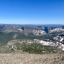
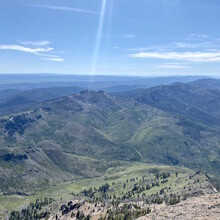
The Strawberry Mountain Wilderness is located just south of John Day and Prairie City, OR and contains larch, spruce, fir and pine forests. Wild strawberry, huckleberry, gooseberry and thimbleberry grow throughout and often trailside. Animals include Rocky Mtn elk, mule deer, antelope, black bear, cougar, mountain goat, beaver and bald eagle. Various trout populate the rivers. Strawberry Mountain rises 9040 ft with a prominence of 4080 ft, an isolation of 46 miles, and is the tallest peak in the Strawberry Mountain Wilderness. The clear warm climate offers endless visibility to the horizon in all directions.
I'd like to increase attention to the beauty of Eastern Oregon and the special nature of Strawberry Wilderness. Although, the route can be done in either direction, I believe a great route is from West to East and that's how I will describe it. The summit of Strawberry Mountain and visits to the falls and lake provide a reward for your journey. I did not include the Skyline Trail which exits at the far southeastern boundary of the Wilderness area. Although, this makes a complete traverse, I feel the trail is less maintained, uneventful and can be much more difficult to access for a car drop or hitching a ride or biking back. A traverse between Canyon Mtn TH and Strawberry Campground provides a full view of the park with stops at the peak, falls, and lake and doesn't add any junk miles.
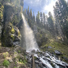
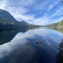
The route begins at Canyon Mountain TH at 5500 ft and follows Canyon Mountain Trl ~16 miles until merging with Pine Creek Trl. Continue southeast making your way along the eastern ridge of Indian Creek Butte. Take note of a left and then right turns ~ mi 17.5 onto a cut trail traveling east to rejoin again with Pine Creek Trl at ~ mi 18.5 near Road's End TH where you will begin to make a northern route on Onion Creek Trl. Shortly after mi 20 you will turn left on toward the summit of Strawberry Mtn at 9040 ft. The climb up Strawberry is quite gentle and stays within the realm of Class 2/3 yds. Make your way back to the Onion Creek Trl / Strawberry Basin Trl jnctn and follow Strawberry Basin Trl east to Strawberry Falls at ~ mi 25, Strawberry Lake ~ mi 26 and finish at Strawberry Campground.
In traditional fashion the route can be done in either direction. The only requirements being the endpoints of Canyon Mountain TH and Strawberry Campground TH using established trails, and a **mandatory summit of Strawberry Mountain.** You will naturally pass by Strawberry Falls and Lake.
full traverse variation as submitted by Christof Teuscher:
This route is a full traverse of the Strawberry Mountain Wilderness on the Canyon Mountain, Skyline (#385), and other established trails. Western terminus: Canyon Mountain TH. Eastern terminus: Skyline Trail TH (1mi off road 62). The traverse can be done in either direction. The route includes a mandatory summit of Strawberry Mountain on either the standard trail or scrambling up the south side.


