Tribal Closures (update July 2022):
When circumnavigating Mt. Adams it is critical to do thorough research on the Yakama Nation Website to check for land closures and to obtain their permit and/or permission before attempting this route. If the land is closed no one should be on it; we have Flagged prior efforts who were on the tribal land during a time of closure. The tribal land may be closed even when the rest of Mt Adams Wilderness is open.
Currently it appears that the Yakama Nation may be issuing permission for recreation on their land at certain times and certain cases, but that should be confirmed with the tribe. Do NOT attempt this route without receiving tribal permission and anyone submitting a time for it MUST include proof of permission to be valid.
Tim Dearden posted the route:
Mt. Adams has an "around the mountain" trail (Trail #9), that is partially made up of the Pacific Crest Trail and the Highline Trail. The east side of Mt Adams is on the Yakima Indian Reservation where there is no trail for several miles across the Mazama Glacier, Klickitat Glacier and Rusk Glacier.
Guidelines:
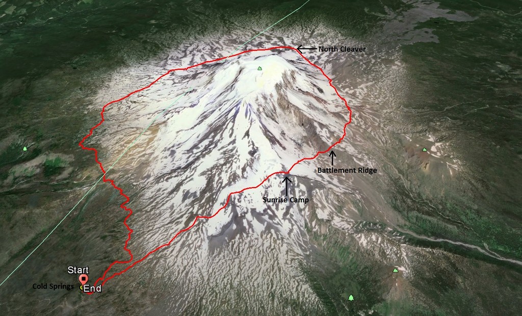
Any route can be followed to circumnavigate Mt. Adams as long as the runner/hiker does not go above 8,500 ft in elevation. The high point is typically Sunrise Camp, on the east side of Mt Adams at about 8,400 ft. If the trail is utilized (where there is one), the distance around Mt. Adams can be upwards of 40 miles. The runner/hiker can also elect to go high above the trail (as long as it is below 8,500 ft) on certain sections that cuts off mileage, but significantly slows the pace as there are countless moraines and glaciers to cross.
Typically, the challenge is started from Cold Springs (elevation 5,300) on the south side of Mt. Adams, but could be started from anywhere, as long as it is from a place that can be driven to with a vehicle.
The "Reverse Lollipop" was first done by Matt Palilla & Seth Wolpin, and consists of climbing up & down the mountain, and then running around it.
Comments
On August 12th, 2018 I ran around Mt. Adams in 7:59:33.
I followed essentially the same route that Lucas King and Tim Dearden took on their previous FKT, going counterclockwise and staying well above the trail on the east side and dropping down to meet the trail on the north side at Devils Garden.
Here is the link to the Strava activity: https://www.strava.com/activities/1768409900
I will attempt to break the Reverse Lollipop or Sum+Circ Record tomorrow.
On July 26, 2019 Tim Dearden and Mason Stock ran around Mt Adams in 7:03:22.
The higher route was followed for the majority of the trip. Starting at cold springs where a sharp climb up to Sunrise Camp on the east side of the mountain staying well above tree line ensued. The route fluctuated between 7000' and 8000' for the majority of the way crossing nine glaciers and countless moraines. The Around the Mountain Trail #9 was intersected just east of Horseshoe meadows where the trail was utilized back to Cold Springs.
Here is the link to the Strava activity: https://www.strava.com/activities/2565584743
I was thinking about this while out on the Rainer Infinity Loop,
For the Reverse-Lollipop tab under this FKT,
(due to the style set before me by Matt and Seth, as the current record holder as of 8-17-19, and just as a some guy who loves mtns)
I would love to see the president of utilizing as much of the trail "as-is-available" were to be held to with future efforts on "reverse-lollipop", and if the trail is ever completed, in my lifetime, I would gladly come do it again utilizing "all trail" for the circ.
I mean it is cool that Alex, Tim, and Mason have bettered their time by largely ignoring the presence of a circ trail and staying up high on the mountain, they created that FKT initially, and it fits with the rules they initially established with their initial route description.
It seems to be pretty clear that the route above the trail is around 1 hour faster (unless Tim and Alex are just in phenomenally better shape)
anyhow, just a humble 'nudge', simply an opinion from some random guy, to a future attempter
just another mtn guy,
Jason
Again, this is not a shot at Tim or Alex, those dudes are awesome. just a hope.
I plan on attempting the "Reverse Lollipop" tomorrow 7/26 in a solo unsupported fashion.
Here's the link to the live tracking:
https://maps.findmespot.com/s/NR8R
Hopefully that link works! Pretty stoked and a little nervous... as it should be ;)
Ashly
I plan to attempt to set a female unsupported time next weekend assuming the weather is good enough.