"The Oregon Badlands Wilderness, so named for its rugged and harsh terrain, lies just 15 miles east of Bend, Oregon, but arrive here and you might feel like you’ve stepped into an all-together different time and place. This is 30,000 acres of fascinating lava flows and ancient juniper trees. You may see pictographs, as the area known today as the Badlands Wilderness is the ancestral land of the Confederated Tribes of Warm Springs and Northern Paiute. These are fragile cultural artifacts that you can admire, but not touch. You will also find some of the oldest trees in Oregon, bright displays of desert wildflowers and castle-like rock formations." [Source: https://onda.org/badlands-challenge]
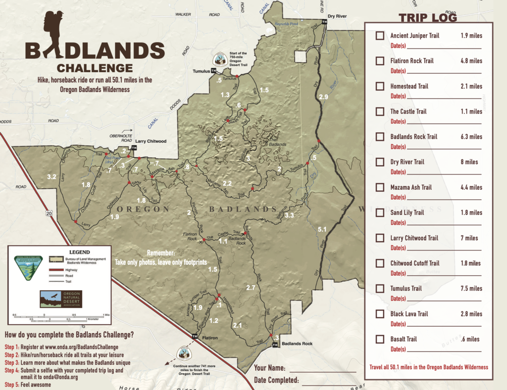
There are 50+ miles of trails in Badlands. The Badlands Challenge consists in covering each and every trail in the Badlands Wilderness in a single push, without leaving the Badlands.
All GPS track are available at https://drive.google.com/drive/folders/1QYkWu11uQxvUQTPYB5VIk9SAYLfAHQ3d
Brochure: https://30723z39riptju122j58z3fx-wpengine.netdna-ssl.com/wp-content/uploads/2019/11/Badlands-Challenge-Map_2020.pdf
Trailhead driving directions:
- Flatiron Trailhead: Head east from Bend on Hwy 20 for 15 miles, trailhead is on the left off the highway.
- Badlands Rock Trailhead: Head east from Bend on Hwy 20 for 18 miles (passing Flatiron Trailhead). Continue another three miles and turn left at the Badlands Wilderness sign. Continue for another mile to the trailhead on the left.
- Larry Chitwood Trailhead: Head east from Bend on Hwy 20 for 6.5 miles, take a left on Dodds Road and continue for 3 miles and take a right onto Obernolte Rd. Continue for 0.5 miles to the trailhead.
- Tumulus Trailhead: Head east from Bend on Hwy 20 for 6.5 miles, take a left on Dodds Road for 6 miles to an unmarked dirt road (right after the 6-mile marker) where you will turn right. Take a right at the fork in the dirt road until you reach a parking area at the canal. The Tumulus trailhead is over the canal walkway.
- Dry River Trailhead: Head east from Bend on Hwy 20 for 6.5 miles, take a left on Dodds Road and continue for 11 miles and turn right onto Alfalfa Market Road. Continue for 3 miles and turn right onto County Line Road. The trailhead is another mile down the road.
Comments
Is the FKT only for a single push of "all" the trails? Or can we obtain a FKT on a single trail such as the Flatiron?
Snazuk,
The admins definitely face a difficulty here. While any named trail could potentially be accepted as an FKT, none of us want people to try to submit each named trail within every single park with named trails...it waters down the meaning of the efforts. In my opinion, when there is a network of trails to choose from, the FKT route should be the best among them or as we see in this effort combinations of them.
I always try to think if a particular named trail is a particularly good "show piece" of the area, like the area classic, when it is among a mess of other trails...answering the question "why this trail and not the others?" might be a good test question.
The Badlands Challenge is clearly a great way to showcase this area. Potentially, this is true of one of the individual trails too. That would just take legwork (some literal, some online research), and research on prior efforts (always best to assume at least someone has run it before with a GPS on).
anyhow those are my thoughts!
If you happen to just have knowledge from your experience that one of these individual trails is "worthy" please do submit it to be accepted.
with stoke,
Jason Hardrath
The Badlands Challenge is about "touching" all the trails in a single push.
gonna give this one a go tomorrow self-supported starting from the flatiron trailhead using christof t's very awesome and helpful video for how to most efficiently cover the trail system!
I note with interest that on the Bend trail map from Adventure Maps that I use as a reference for the general region, there's a couple of trails that aren't accounted for in the challenge. Both of these are to the east of the Dry River, one is 3.3 miles and parallels the north of the Dry River, called the Sand Trail, the other connects to the Sand Trail and is called the High Desert Trail although it doesn't have a mileage listed. I'm guessing that these trails have been abandoned since the map was printed, since they don't look they would be of much interest to hikers outside of such a challenge as this. Does anyone know of the fate of these trails?