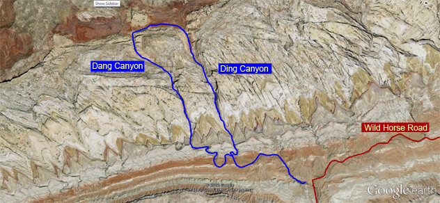
Ding & Dang Canyons - 2A II-III (5.4yds) - This semi-technical canyons loop is one of the top-rated and frequently written about canyons loop in all of the San Rafael Swell area of Utah (second only to Little Wildhorse - Bell Canyons Loop, which is its non-technical next-door-neighbor). The rock and movements are amazing. You will want to do these loops slow to savor the views before doing them fast. But once you have rehearsed them, these Utah canyons are nature's obstacle course races!!! ...and this one is phenomenal and a classic!
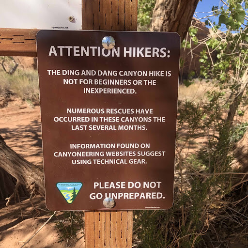
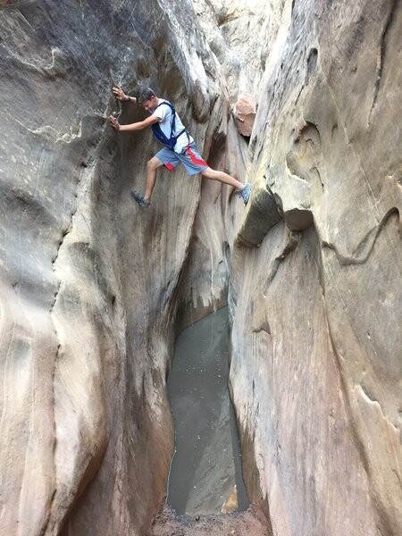
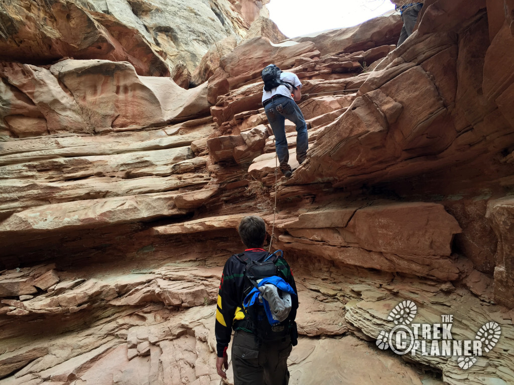
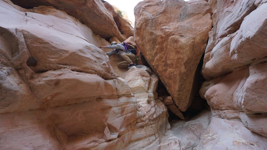
Forewarning: See first photo. Dang Canyon is not to be taken lightly. It includes multiple, albeit short, technical elements going at a sand-covered 5.4-5.8yds, there may or may not be fixed webbing on these technical obstacles, do your research first. Always project a canyon with technical aspects. Never descend down a canyon without knowing beforehand what obstacles will be encountered. I recommend hiking up Dang Canyon through all the obstacles, then back down them first (potentially with gear and with a partner) before you make an attempt on this loop to check that the webbing fixed lines are in place and in good condition. Canyoncollective.com says, "Ding is fairly straight forward with a few obstacles while Dang has a few more climbs and tends to hold water that can be easily stemmed or waded. No technical gear is required but short rope for a hand line is suggested for groups who are less confidant in their climbing abilities."
Be Kind (and a good representative of the FKT community) time fast efforts to avoid peak tourist times: Slot canyons are narrow (no duh) but that means there is not always space to pass. Many tourists and canyoneering enthusiasts like to enjoy canyons slowly, please be respectful of their experience. Choosing an early morning start or a just before sunset start time may be essential to not get stuck behind these groups. Its a win-win to avoid ruining your time and their experience by choosing a courteous start time. (a good indicator may be the number of unoccupied vehicles at the trailhead)
Hiking Project has the following description:
"Overview
This is a beautiful canyon hike with some challenging sections. There are obstacles in both Ding and Dang canyons but you can get past them by utilizing nearby ledges with a little help from your friends. It is easiest to head up Ding and down Dang. There are a couple of dry falls with bolts. Tieing a hand line (bring a 50' rope) is advised to help you and your party get down some of the spicier sections.
If you want something a little more challenging than Little Wildhorse Canyon Trail, give Ding & Dang a shot.
Need to Know
• This is located in a desert so bring plenty of water, especially in the hot summer months.
• Check the weather before you go, as being in a slot canyon during a storm can be deadly.
• There may be water in the canyon that you'll have to wade through.
• Rope may not be necessary for the bold, but 50' of rope will be helpful in a couple of technical spots.
Description
To get there, head toward Goblin Valley State Park on Goblin Valley Road. Just before you get to Goblin Valley State Park, turn right onto Wild Horse Road. The road is paved until you get to the Little Wildhorse Canyon Trailhead, after which it's a dirt road for just over a mile until the road takes a sharp turn to the south. The trailhead will be directly on your right in the middle of the curve.
From the trailhead, head up the large wash for about a mile. When you get to a clear ridge where the two trails come together, take the right fork to head up Ding. Follow the wash up a narrow section where you'll see some potholes and dry falls. You can get past most of the dry falls on the right side, and none of them are too difficult.
As you get to the top of the canyon, it opens up and you'll be able to see Ding Dang Dome. After enjoying the view, follow an old road to the left (west) that will drop you into Dang. As the canyon narrows, you'll encounter a set of dry falls that can be a little challenging. There are some 10' drops that could be tough, so remember to use your hand line. You can pass on the ledges on the right, but with a little help from friends (and your rope) you can get past these dry falls.
As you continue down the canyon, you'll hit some chokestones that can be conquered with help again from friends and maybe your hand line. You'll know you've made it to the bottom when the canyon begins to open up in front of you. Follow it left as it makes its way back to joining the section you came in on and the trailhead."
Continued Research:
https://static1.squarespace.com/static/58d5543e9de4bb1b19e81da4/t/5a00cab253450aa14e5c7efa/1510001337983/DingDangCyn.pdf
https://www.grandcanyontrust.org/hikes/ding-dang-canyons
http://canyoncollective.com/betabase/ding-and-dang-canyons.49/
Comments
It feels slightly awkward posting this here (I'm not trying to promote my page or get new followers)... but if anyone is interested in a short compilation of clips from the loop here's a link:
https://www.instagram.com/tv/CPIvaxplLgv/?utm_source=ig_web_copy_link
It's artsy and personal because it's mostly for me and my husband and our friends and family, but you definitely get an idea of what the canyons are like.