Along with the Continental Divide Trail and the Appalachian Trail, the Pacific Crest Trail is one of the "Big 3" National Scenic Trails. It runs 2655 miles from Mexico to Canada, through the Sonoran & Mojave deserts, and then over the Sierra Nevada and Cascade mountain ranges. The PCT crosses California, Oregon and Washington, and passes through 24 national forests, 7 national parks and 33 wilderness areas.
We report FKTs for trips of various style on the entire PCT, and for particular segments. And note that previous FKTs on the full PCT have established a tighter standard for the Self-supported style on this route: no vehicle is ever used; the hiker/runner walks to re-supply rather than hitchhiking.
The PCTA or USFS may designate official "Alternate routes" for sections closed for fire or other reasons. If so, the re-route becomes the official PCT for that season and will count as an FKT. If the route becomes longer due to a re-route, that must be accepted by the attempter as part of the PCT; there will be no time adjustments. Going into officially closed sections would invalidate an FKT, even if it normally is an open section of the trail. Taking any detours not designated or approved also will invalidate an attempt. Fires and re-routes are to be expected, so the attempter is strongly advised to stay up to date on the trail status, as it will likely change during the attempt.
PCT Trail Closures. Trail Conditions reports.
A few people formerly argued the official/original trail must always be taken, but since closures and re-routes are now common, such a rigorous standard would mean the PCT could often not even be attempted, so our standard of requiring the trail designated for that specific time frame is fair and reasonable. As always the most important thing is to report exactly what you did in terms of style and route.
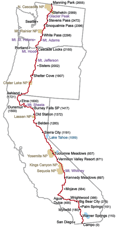
Overview map from the PCTA here. PCTA interactive map here (includes fire layers).
Note on yo-yos: It appears that in 2007, someone named "Eric D" yo-yoed the PCT in 183 days, according to this report from well-known trail angels Scout and Frodo: https://www.trailjournals.com/journal/entry/210431 We don't have much more information on it so this isn't a verified, official FKT listed on the site, but a male attempt on a yo-yo FKT is encouraged to beat the 183 day time.
Comments
Hi, Jupiter here. Just wanting to claim my intentions publicly for this year that I will be attempting to break the self supported yoyo fastest known time on the Pacific Crest Trail set by Eric D in 2007 in a continuous 5,300 miles hike from Mexico to Canada then back to Mexico. Scott Williamson in 2006 completed this feat in 191 days besting his first successful hike, while Eric finished in 183 days just a year after. The later number is my aim. My intention is to do it in the same style Scott has coined over many long hikes in the past, as a backpacker carrying all of my food water and equipment between towns, without vehicle support following me up the trail or meeting me in any fashion, while also walking in and out of all my town stops. Should any of that change, or I deviate from in a subtle way I'll be honest about doing so. I will follow the official route of the PCT the entire way but in the likely event of a closure for fire or otherwise will take an official detour as Joe/Karel did on their supported hikes. I will not be carrying a spot or inreach, which I guess you guys can argue with me later if someone finds my documentation to be lacking, that is ok and this whole thing will just be for me as ultimately I do this because I love to and deeply want to. As for the speed aspect it is also just something I love. I post here to you all out of respect for those who come before me, and paved the way, cracking the code, and solving the puzzle. I'm not the first, and won't be the last but thank dearly everyone who makes this possible, and has inspired me over the years.
As I hike I will update most to instagram, but also will post photos or story to facebook, blog, and youtube whenever I find I have time which should be pretty often. I plan on documenting the journey heavily which will hopefully help later with any sort of verification. If you're interested in following I don't think I'm too difficult to find.
In 2016 I hiked the 4,800 mile Eastern Continental Trail in a very similar style without much vehicle assistance, and even ending with an FKT on the Florida Trail. This yoyo of the PCT is what I dreamt about while out east, culminating in an obsession for the next year, and the deep planning of for the past 9 months.
I start May 10
ps I'd say see you out there Shiggy, but I think that would mean one of our attempts went wrong!! So here goes, goodluck.
Jupiter
"Shiggy" sent the following comment: Hi, I am going to follow Jupiter's example and state my plan on this new website too. As Jupiter I will try FKT for PCT yo-yo in the same style like him. I will start 05/22 and will use Garmin In reach set at 30 min. intervals (limited by battery).Also will take selfies at important points like trail junctions as far from closest road as possible. I will try to ask for emails from fellow hikers but that is not very good. P.S. Jupiter, hope to see you somewhere in Washington!
NOTE: Shiggy quit after about 1000 miles, having lost too much weight.
Starting June 17th, 2018 I will begin my journey in attempting to beat the current self-supported FKT on the PCT (Northbound) held by Heather "Anish" Anderson. I will be doing it "thru-hiker style" as Scott Williamson laid out in his 2008 FKT - no support crew, *no vehicles, using mail drops, and picking up food and supplies in towns along the way. There are fire closures this year so I will take the the official detours. I will be tracking my trip with a SPOT device and a GPS watch which I will be uploading to Strava. * NOTE Regarding Vehicles: It's my goal to never use a vehicle, however, in the event of an emergency due to illness, injury, or in dire need of food / supplies, I may take a ride in a vehicle. If so, I will then return to the exact same spot I left the trail and continue on. I will set a marker of the location using my SPOT device for when/where I leave the trail and also when I return. I This method is used and accepted durning most ultra-marathons in which there is a high level of risk (i.e. Badwater 135). In the event of a fire closure where no walkable alternative is available (i.e. Eagle Creek Fire Closure) I may need to take a vehicle then. In this instance I will hitchhike or take a shuttle, whichever is recommended by the PCTA. No vehicle will be pre-arranged as I would consider that to be supported.
www.facebook.com/allllwright
www.instagram.com/allllwright
www.strava.com/athletes/allllwright
www.allllwright.com
Currious- what are the restrictions on using a food resupply service, such as the Sonora Pass Resupply (paid service that delivers a box to you on the trail at Sonora Pass, where resupply options are otherwise poor)? Would using such a service make your hike no longer "self supported"?
The guiding principle of self supported is that you can use whatever is available to everyone, and that is commonly used. A paid resupply service that is available to anyone would be fine. Paying your friend to bring food for you would not. I think you could get into a gray area if you use some kind of service that isn't commonly used. I could imagine a person getting a food drop by helicopter and claiming that's available to anyone, but to me that's obviously supported. I guess when in doubt find out what Williamson did!
Unfortunately, I most likely won't be attempting the FKT this year. On my way out to the trail I got an appendicitis and needed immediate surgery. It may be too late to start by the time I heal up and get my fitness back.
Buongiorno a tutti,
sono qui per avvisare riguardo la mia partenza il 15 giugno e le mie intenzioni nel tentare di battere il record esistenti ora per percorso yo-yo dal Messico al Canada e di nuovo al Messico. Potenzialmente cercherò di battere anche il record “southbound”. Il tutto lo farò in modo “selfsupported” quindi avrò il necessario sempre con me e mi affiderò ad alimentarI o supermercati per i miei rifornimenti di alimentari ed eventualmente acqua qualora non sia disponibile da risorse naturali, fontane pubbliche o simili.
Nel eventualità di deviazioni dovute ad incendi o qualsiasi altro motivo seguirò là deviazione ufficiale qualsiasi essa sia. Cercherò di documentare tramite Instagram (lorenzofrancosantin) o Facebook ( Lorenzo Franco Santin Photos ) gli avvenimenti e quant’altro io ritenga interessante e/o opportuno.
Lo stile scelto prevede che io raggiunga qualsiasi punto di rifornimento completamente a piedi,pertanto, l’eventuale salita su un auto, mezzo pubblico o simili, bicicletta, skate, e più in generale qualsiasi altro mezzo decreterà l’annullamento immediato del tentativo in corso.
Utilizzerò un dispositivo Garmin InReach è questo sarà il link ( eur-share.inreach.garmin.com/lorenzofrancosantin )tramite la quale sarà possibile seguirmi con aggiornamenti ogni mezz’ora. Di notte o quando starò dormendo spegnerò il dispositivo.
The fabled PCT Long Distance Permit will be back for 2021, after being cancelled in 2020. If you are interested in the PCT, you really need to apply for this on January 19 (and only January 19!) It is possible to do the PCT with permits for each jurisdiction, but that would total a mind-fuddling 20 permits.
Clay Evan wrote this outstanding article on permitting the 3 US long trails - a must-read for anyone considering the big 3.
Note on yo-yos: It appears that in 2007, someone named "Eric D" yo-yoed the PCT in 183 days, according to this report from well-known trail angels Scout and Frodo: https://www.trailjournals.com/journal/entry/210431 We don't have much more information on it so this isn't a verified, official FKT listed on the site, but a male attempt on a yo-yo FKT is encouraged to beat the 183 day time.
I really appreciate this thoughtful and honorable statement by Timothy, his family and crew! Trails continue to evolve, and with climate change western wildfires will become worse - we have to adapt to the current situation, while still being totally fair to those who came before. I believe they are accomplishing that wonderfully. Timothy is still on pace - as of yesterday he was 1/2 day ahead of Karel Sabbe's timetable - having to take time to drive around the large closure may push him back a bit. They are making a very strong effort and I wish them they very best!
Fkt judges and their hypocrisy boggle my mind!
FIRE UPDATE: In case it wasn't self-evident, there will be no further approved FKTs on the full PCT during 2021. On August 17 the huge Caldor Fire caused a closure on 54 miles of the PCT plus parts of the Tahoe Rim Trail. That brings the total to about 334 miles that are currently closed due to active wildfires.
"The PCT experience may never be the same" This fine article appeared in the PCTA blog and is well worth reading.
Hello Everyone,
Beginning early next week (6.5.2022), I will be attempting to set a new self-supported FKT of the Pacific Crest Trail. I first hiked this trail in 2015, and it changed my life. I am looking forward to experiencing the PCT in a new way and to revisiting all of the magnificent places along this path. Much love and respect to all of those that have come before me. I especially want to thank Anish and Stringbean for their guidance and encouragement. I will follow the guidelines set by Scott Williamson and Heather 'Anish' Anderson during their self-supported hikes. I will not get into a car for any reason, and if I do the attempt will be over. I will be walking in and out of all resupply points. I have mailed myself resupply boxes to points along the trail in advance of my attempt. I will not go through any fire closures, and I will not have any planned support along the way. I will post a tracker link before my hike begins, so that there is transparency with my hike. I will also be backing up my route and mileage data with my watch and hope to upload this data to Strava (Witt Wisebram) whenever I have enough service or wifi. I will also be updating my social media (Insta - @yung.chattahoochee) periodically throughout my attempt. Thank you to this community for your support over the years!
Peace,
Witt
Hello,
starting on June 13th (probably!) I will be starting a self supported fkt attempt on the pct. I will begin at the border in campo and go nobo. In accordance with the established style, I will not get into a car. I will not go through fire closures and intend to walk any required reroutes. I have mailed myself boxes to all resupply points.
My tracker link is: http://share.garmin.com/redridinghoodella
instagram: redridinghoodella
all of my miles will eventually end up on Strava too, will update as best as I can while hiking.
huge thank you to Alex wright for all of his help with this attempt as well as to Witt and Josh.
Peter Bakwin changes rules and regulations every year.
Maybe you forgot when you bashed AT FKT 2017 ???
Now you can get in a car and go around a fire burns?
Come on people!
Last year there were two blitzing PCT yoyos.
Joe Alonso finished a PCT yoyo in 161 days according to his Instagram. Looks like 76d17h northbound and about 84 days southbound.
https://www.instagram.com/p/CkCLObYPuoN
A few days later, Nina "Mooch" Bridges finished a yoyo in 190d6h according to her instagram, becoming the 7th person to do so and I believe the second female, on her first thru hike!
https://www.instagram.com/p/CkCDStRyEjR/
I don't believe either was doing the tracking/verification necessary for an FKT, but surely anyone going for a yoyo FKT in the future would want to beat these notable times.
Hey there. Retune here. June 11, 2023 I will begin a self-supported FKT attempt on a YoYo of the PCT.
After finalizing resupply boxes, I intend to attempt in typical self-supported thruhiker fashion without support of vehicles. I plan on walking for all resupplies.
My only exception will be if I have any issues with type 1 diabetes medications in which I will make note of the reason and return back to connect my footpath and continue on.
As for any closures and reroutes I will assess on a case by case basis and document accordingly while trying to remain true to the red line as much as possible.
In 2023, Joe Alonso finished a PCT yoyo in 161 days. I will be setting that as my target to beat. I saw Joe several times during his yoyo and he really inspired me to want to attempt a yoyo. Due to my delayed start I will have to beat it to get back south in time.
Happy trails!
Tracking info:
BIVY: www.bivygate.com/1rm17
STRAVA: https://www.strava.com/athletes/1791662
INSTA: www.instagram.com/sweet.hiking
Hello!
Matthias here, I am an 40 year old Ultra-Trail runner from Austria. Starting around August 6th 2023 I will be attempting a sub 55 day self-supported speed record on the Pacific Crest Trail going southbound from Canada to Mexico.
Since I have finished my thruhike of the PCT in 2011, I always wanted to come back and it seems the time has finally come!
I will walk in & out of my resupply locations without using vehicles. However, in the case of an emergency, injury or breakdown of essential gear I may take a ride in a vehicle from and back to the trail which is within the guidelines of a self supported effort. If so, I will return to the exact same spot I left the trail. I will send some boxes with food and gear replacements in advance, but most of my resupplies will be bought locally. For verification I will use a GPS watch and upload to strava at least once a week.
To follow along best chance will be my facebook which I will try to update on the go.
I am raising money for „Austrian Cancer Aid & Research“. Please donate via the link on my facebook, my website or using the details below.
Donations:
Österreichische Krebshilfe
Bank: BAWAG P.S.K.
IBAN: AT85 6000 0000 0204 6000
BIC: BAWAATWW
Plz use „PCT2023“ as purpose of use
Link: https://www.krebshilfe.net/spenden/online-spenden Kennwort „PCT2023“
Thank you!
Matthias
strava: http://www.strava.com/athletes/6370003
fb: https://www.facebook.com/htmatthiaskodym
Karel has posted a wonderful one hour film about the new PCT FKT, enjoy:
https://www.youtube.com/watch?v=IeGFmm4Krho&t=4s
Cheers
Torben
I will begin my self-supported FKT attempt on June 16th, 2024. No cars, no cacheing.
Live tracking and social media links can be found on my website:
www.allllwright.com
–Alex Wright, aka “Willy Wonka”
Hi everyone,
I just post this message, to say, i set the first french fkt for the PCT in 65 days last year, it's honor to be in this PCT family and in part of the small group of people who ran the PCT. My dream now is to set the overall FKT of Karel Sabbe in few years. I think it's possible with a solid crew and because he lost 3 days during this adventure in the Sierra and in the end. Stay connected !
My instagram : @antoineclmtt.
Hey everyone,
I'm Jonathan (trail name: Janis Joplin). Today I'm beginning my self-supported attempt for the California section of the PCT, along with the entire trail. You can follow along on at this link: exoticpax.com/pages/pct-fkt
or on IG: instagram.com/jonathanpatrickthomas.
I'm looking forward to chasing the times of Nick, Josh, and Karel!
Happy trails!
JJ
Hi there, Jules here – I’m attempting to set a new FKT going southbound on the PCT starting on July 1st, 2025 at the northern terminus.
Hello everyone!
Becca here, aka Skittle or Little Skittle, from WA state. Within the coming week I’ll begin my attempt of a new womens self supported FKT of WA, and also the entire trail, starting from the Northern Terminus. When service allows I will provide updates on my Instagram: instagram.com/ms_rebecca_ann
Looking forward to hiking the PCT again and chasing the ghosts of Ella and Jessica. Also, can’t wait to high five Liz!
Happy trails!
Hi everyone,
this is Katha (Ninja*). Within the next few days, I am about to start my self-supported FKT attempt of the PCT, going SOBO from the canadian border. According to the guidelines, I sent myself resupply boxes all along the way, will not get into a car, will not walk through fire closures and will not get any kind of outside support.
I hiked the PCT already in 2019 and had the best summer of my life - if this adventure is just half as fun, that's probably enough. Tbh, I've been slightly intimidated by the strong field this year and am curious to see what the odds are that my hike will be whatever kind of success.
I will be tracking myself with a garmin inreach and will share that data after the hike - but in case you want to follow along, you can join me on insta: @tenmillion_bicycles , there might be a post here and there.
See you down the trail
Hello! Unfortunately I had to quit my attempt a couple of days ago due to shin splints and other surprises my body had in mind. It was fun trying tho and I am grateful I got to give it a shot.
Julie Brock, at age 59, completed the PCT North to South in 69 days, 19 hours, and 27 minutes, just a few days shy of the record of 63 days.
Her trip report is as follows:
As a 59 year old female, I wasn't sure what time I could achieve on the whole PCT but thought I would just give it my best shot. I set out on August 1st from Harts Pass and headed up to the Canadian Border. Once there I had a break and then at 2.06pm I set out on my biggest challenge. I headed back to Harts Pass where my partner was waiting for me. I camped in our RV that night then set out the next day and so on all the way to Mexico.
My days were determined by where Dave could get the RV into. Some days were long and others were shorter. My longest day was 100miles and the shortest day was 12miles. I sometimes had to take a side trail to be able to meet up with Dave but the next day I would return to the PCT where I had left it and continue southbound. I got to meet lots of fellow hikers and I often stopped just to take in the stunning views. I was always in awe of the beauty the trail had to offer. I would take photos but they never did any of the scenery any justice. I got to see so many beautiful sunrises and sunsets, hiking under the full moon and star filled sky's.
I was lucky that I only had about 2 days of rain the whole trip and I also didn't get affected by any of the wildfires, although I did miss one by only a few hours.
There were some low moments where I just wanted to give up while in particularly technical parts, but once back at the van and a good feed and sleep I was ready to go again.
I hope this can inspire someone else to have a go at a dream they have
https://connect.garmin.com/modern/activity/20679782388
Hello! This summer I attempted a self-supported PCT FKT in the northbound direction. I ended up completing the trail in 69 days, 13 hours, 53 minutes.
It was my first self-supported thru-hike of this magnitude. I wrote daily reports via Substack at https://pinkfeathers.substack.com and you can find my GPS data on my Strava. I shared some finish photos at the northern terminus on my Instagram here.
It's hard to sum up a journey like this in words, but all I can say is that it was a beautiful experience. I feel fortunate to have had no issues with closures, and was happy to have an unbroken footpath from Mexico to Canada. I continued to follow the self-supported guidelines even after it became clear there would be no record, simply because it's what I wanted to do.
I'm so glad to have crossed paths with Jules and Ninja on their southbound journeys, and big congrats to Julie, who I didn't get to meet, on also completing the trail in 69 days this summer! I believe that makes us the 3rd and 4th fastest women to have completed the PCT. I'm excited to see what the future holds for women on this trail!
~Liz
Greetings PCT FKT community,
This summer, I embarked on (another) failed PCT FKT attempt, this time thwarted by illness at the end of day 25. I’m proud to report that I ran 1125.9 miles ahead of record pace, and was the fastest woman ever thru Southern California (14d 5h 22m terminus to Walker Pass) / the PCT desert (15d 7h 25m terminus to KMS, mm 703.4).
After much hesitation after my 24 experience, I decided to go all-in on this attempt. My husband and I bought a car that I (re)learned to drive and lived out of for over a month. I took a lengthy leave of absence from work. I invested thousands of dollars and countless hours into training, gear, food, and other preparations. I worked for months with other record holders and attempters to perfect my resupply strategy and logistics. I worked with a coach, dietician, therapist, chiropractor, and acupuncturist. I tried to leave no stone unturned. I hope the results are indicative of all the energy and effort, my own and others, that went into this attempt. It was truly a labor of passion and love.
Huge thanks to everyone who encouraged, supported, and helped me on this journey, there were many of you, but especially my core virtual team, Nick, JJ, and Sven. Special thanks to JJ and Exotic Packs for outfitting me with the perfect bag (FKP FTW!) and Jameson and Houda Trail for customizing the best running dress.
Thanks to Heather for this formidable, and truly life-changing challenge, and to Emily, who's ghost I had the privilege of chasing for over 900 miles.
While I ultimately did not set the record, I hope my attempt can inspire others to go all in on their dreams, too.
Miles per day as follows:
D1: 53.2 + .9 bonus miles - start at 1:57am at southern terminus (photo)
D2: 46.2
D3: 52.4
D4: 43.6
D5: 44.8 + .2 bonus miles
D6: 48.1
D7: 49.3
D8: 44.5 + 2.2 bonus miles - power out at Cajon Pass, resupply location closed.
D9: 47.2 + 1.1 bonus miles
D10: 44.9 - first and only shower, forced upon me by Farmer John (thanks, Farmer John!)
D11: 49 + .2 bonus miles
D12: 39.9 - tendon issue in left wrist, lost functioning for remainder of hike
D13: 40.6 - 12hrs on 3L of water
D14: 30.8 - made plan to quit at Walker Pass
D15: 48.5 - decided not to quit
D16: 40 + 1.4 bonus miles (split to KMS - 15d 7h 25m)
D17: 43
D18: 34.9 - forrester pass (snow), glen pass (snow)
D19: 36.8 - pinchot pass, mather pass (snow)
D20: 38 - muir pass (snow)
D21: 38.9 + .6 bonus miles
D22: 36.2 - donahue pass (snow), broke cold soak jar
D23: 35.1
D24: 40 - wind/rain storm on sonora pass
D25: 40.5 - sick at end of day
D26: 29.1 - sick
D27: 18.2 - sick, collapsed on trail
D28: 12.2 - desperation hike out. Hardest day of hiking of the entire trail.