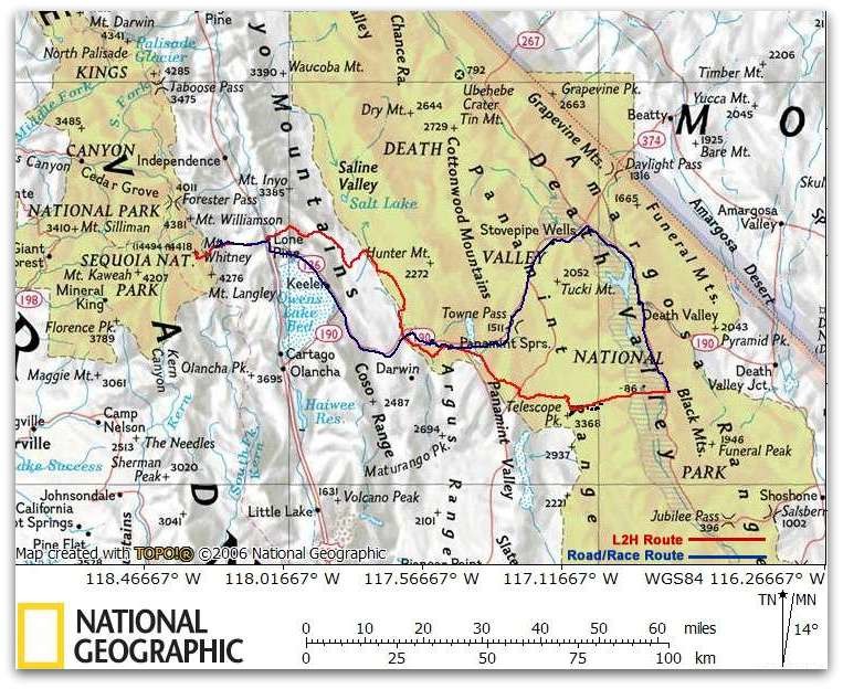
Location
California,
US
Distance
131.6 mi
Description
GPS Track
L2H-main-route.gpx226.49 KB
FKTs
Male
Female
Mixed-gender team
| Shaun Burke | 1d 23h 14m 16s | ||||
| Sean O'Rourke | 2d 5h 9m 9s |
| Sara Aranda | 2d 15h 29m 0s |
| Ariane Arndt, Matthew Morrison, Anthony Ottati | 3d 8h 31m 0s |
| Emma Erwin, Larson Lovdal, Jack Kerby-Miller | 5d 6h 53m 12s |
Images
Comments
The documentation provided above gives a good, reproducible "FKT Route". However, a mostly-off-road Badwater-to-Whitney trip was done by Blake Wood during October 21-23, 2002. Blake was supported by his father, and reached the summit of Whitney in something under 58.5 hours from Badwater, and Whitney Portal in right about 62 hours. His route was very similar to the L2H Route described above through Darwin Canyon, but then Blake went further south through the town of Darwin, across Lower Centennial Flat, and straight across Owens Lake (which turned out to be a bad idea). Blake's route rejoins the L2H Route at Lone Pine Campground. His evocative trip report was published in Ultrarunning Magazine, and is also below.
Badwater-Whitney Run
10/21-23/02
Blake P. Wood
It was hard to swallow the feeling of panic as I sank up to my knees in the stinking green mud, the sharp salt crust cutting into my shins. I was alone in the middle of the Owens “dry” lakebed, several miles from the shore in each direction, and surrounded on three sides by standing water. About seven miles in the distance, shimmering in the late afternoon heat waves rising from the lakebed, I could see the clump of trees at the Lubken Creek-Hwy 395 intersection just south of Lone Pine, where my Dad awaited my arrival. I keenly regretted my decision not to carry the radio on this leg of the run.
Wrenching my legs out of the mud, I broke through again, then on the third step the crust held. Turning around I noticed that the footsteps behind me were filled with briny water. How deep would I sink next time? Up to my crotch? What if the mud sucked off a shoe – how would I cover the miles of sharp salt crust between me and the surrounding desert sands? Already the headlines were playing in my head – “Idiot tries to cross Owens lakebed. Rescued by helicopter.”
Well, I didn’t sink out of sight, although it took me substantially longer to reach the spot where Dad waited with a hamburger and milkshake – now cold and warm, respectively. The ordeal left me exhausted, both emotionally and physically. The Owens Lake crossing had intrigued me, as I’d never heard of anyone who had tried it. Now I know why. But I’d been running for about 110 miles at this point since leaving Death Valley before dawn the previous morning, and the shafts of light thrown by the sun setting behind Mt. Whitney beckoned me on. Tomorrow I’d stand on that summit.
But, back to the beginning… I have nothing but respect for those who participate in the Badwater-to-Whitney run each July, but the thought of running that many miles down a highway in the summer heat leaves me cold.
However, the concept of running from Badwater (the lowest point in the Western Hemisphere) to the top of Mt. Whitney (the highest point in the conterminous U.S.) has a lot of appeal. The thought occurred to me that I could do this run cross-country, with my Dad meeting me periodically with food and water. That sounded like a lot of fun!
Given that I’d be running for many hours between water stops, it would be suicide to do this run in the summer heat. The best plan would be to fit it in as late in the season as possible before the winter snows made the ascent of Whitney difficult – probably October.
I had three criteria in setting my route: first, to stay off pavement as much as possible; second, to begin by ascending directly to the top of 11,048’ Telescope Peak; third, to follow roughly a straight line from there to Whitney. Other than that, and some tentative meeting points that Dad and I agreed to while driving from Lone Pine to Death Valley the day before, the plan was to make it up as I ran.
Dad left me at Badwater just before 3:30 a.m. on October 21, 2002. I could pick out Telescope Peak on the skyline, nearly in line with our initial meeting point at Shorty’s Well, about six miles across Death Valley. This would keep me going in the right direction until I could see the light Dad promised to put out on his car.
The darkness was beautiful! There was not a single light to be seen beside the moon and stars – no streetlights, house lights, or car headlights anywhere in view. The only sound was the cool breeze ruffling my shirt. The pure white salt pan had split into polygonal sections about six feet across, each surrounded by a ridge a half foot high where moisture from below seeped up and evaporated. These were easy enough to run across, but it was hard to shake the uncomfortable feeling that I was running on a field of pack ice might at any moment crack and send me into cold waters below.
At Shorty’s well I picked up my Camelback with 3 quarts of water, my camera, FRS radio, and a couple sandwiches. We estimated that it would take me another eight hours to reach the summit of Telescope Peak, still more than 11,000’ above me and a dozen miles away as the crow flies. Dad planned to drive to the Mahogany Flat trailhead and hike in to meet me on the ridgeline below the summit.
Dawn found me among the foothills of Hanaupah Canyon, the cliffs around me lit up orange by the rising sun. I was surprised to discover a gurgling creek in the canyon bottom surrounded by thick brush.
Just short of Hanaupah Springs, at about 3,800’ elevation, I started climbing in earnest, heading north to the ridge separating the south and middle forks. On a chance, I tried reaching Dad on the radio – it was 8 am, and by now he might have reached the ridge 6,000’ above me – and was surprised when he answered. He said he’d go to the top, and wait for me on his way down.
I climbed through beautiful cactus gardens among the loose shale and sharp limestone boulders, which gradually gave way to juniper and piñon. The ground was littered with piñon cones stuffed with nuts, which I collected by the pint and ate as I climbed, ignoring the sappy mess it made of my hands.
Around noon I reached the ridge trail at 10,000’, and in a few minutes met up with Dad, who was descending from the summit a mile further on. I had foolishly neglected to top off my water in Hanaupah Canyon, and had run out an hour before. Luckily, Dad had carried 2.5 gallons of water six miles in from his car, plus a couple extra sandwiches. I dropped my pack and reached the summit at 1 p.m. – only 30 minutes behind my estimated schedule. To the east I could see Badwater, impossibly far below. To the northwest I could make out Mt. Whitney on the horizon, 73 miles distant. It looked really far away!
Jogging down the trail I caught up with Dad after a few miles and we hiked together to the point where I planned to descend into Tuber Canyon, which I’d follow to the Panamint Valley far below. The map showed a dirt road along the canyon bottom, but when I reached it after a couple hours of steep scrambling, it was almost nonexistent.
I soon learned to trust the feral burros that inhabit the area – if their trails suddenly climbed the canyon walls for no apparent reason, it always meant that there was some obstacle in the canyon bottom ahead – usually impenetrable brush surrounding an intermittent spring.
Five p.m. found me exiting Tuber Canyon and beginning a difficult traverse of the pediment, climbing in and out of small canyons that cut the slope across my path as I headed for the Wildrose Canyon road where Dad was waiting. The evening sun lit up Telescope Peak above me, gradually turning to purple in the gathering dusk. Beautiful!
During my descent of Tuber Canyon, became increasingly uneasy about crossing my next obstacle – the Argus Range on the other side of the Panamint Valley. The plan had been to ascend to the head of one of its canyons and pick my way cross-country over its summit. This was a frightening prospect now that I realized that the canyon bottoms are difficult to negotiate, they often end in bands of cliffs, and that I’d be doing it alone and in the dark. I decided instead on an end run – I’d head for the town of Panamint Springs, then follow the highway for a couple miles to the 4WD road up Darwin Canyon.
After a cold and windy dinner cooked in the trunk of Dad’s car, I followed a series of washed out dirt roads to Panamint Dry Lake, which was a fine, smooth, beautiful run in the moonlight. No flashlight was needed to find my way, as I could see the light on Dad’s car miles in the distance, but I shined my flashlight in Dad’s direction occasionally anyway so he would know where I was.
I was running through the moonlight along the highway out of Panamint Springs at about 11 p.m., when a walking figure suddenly appeared in front of me in the road. He warned me of potential trouble.
“Just ahead a car drove by slowly, then killed its headlights, pulled off the road, and stopped. I don’t know what’s going on, but you’d better be careful!”
“Oh!” I replied. “That’s just my Dad.” “Your Dad?” he asked blankly. “Then… you know him?” I assured him that I did, and we bid each other good night. Neither of us asked the other what they were doing there, showing a surprising lack of curiosity, I suppose.
At about midnight I set out along the 4WD road up Darwin Canyon. At times I could hear the feral burros running through the brush around me, but my flashlight wasn’t powerful enough to actually spot any of them.
I began to get punchy, and at one point laid down on the side of the road for a 20 minute nap. As the night wore on all my usual tricks for staying awake failed me. It was too cold to take another nap - the temperature dropped to near freezing as I climbed toward 5000’ elevation. I staggered along, dozing off until I walked into the ditch on one side of the road, then straightening myself out and walking until I stumbled into the ditch on the other side. It would have been funny if I hadn’t been so frustrated at the slow progress I was making. Finally, at about 4:30 a.m. I jogged into Darwin and crawled into the front seat of Dad’s car for a 45 minute nap.
Darwin is a funky little town. Founded in the 1870s with the discovery of a rich silver deposit, it had one of the highest murder rates in the old west. It went bust in the 1880s, but enjoyed a rebirth in the 1940s as a major producer of lead. The mines have since closed and a highway realignment diverted the Death Valley traffic away from the town. “Dogpatch” meets “the Burning Man Festival” is how I can best describe it – amidst the squalor, many yards sport strangely beautiful sculptures welded out old car parts and other junk. Worth a drive through if you’re ever nearby.
At 6 a.m. I set out again. Crossing a low rise a few miles west of town, I was treated to a glorious sunrise – yellow streamers radiating around Telescope Peak to the east, the full moon setting over the Sierra Nevada to the west. Large black ravens bobbed and croaked at me in the morning chill from their perches on the surrounding Joshua Trees. Mt. Whitney was in view now – still a long way off, but a whole lot closer than it had been from the top of Telescope Peak the previous day.
I met Dad at a decrepit old corral at the junction of two dirt roads in Lower Centennial Flat for a quick breakfast out of the trunk of his car. He pointed out a faint dirt road heading out across the desert in the direction I wanted to go – not shown on any of our maps. I ran along it until it disappeared into the sand and brush, then headed cross country to pick up a good dirt road that would lead me to the edge of Owens Lake, meeting Dad there a little before noon.
Owens Lake was a 100 sq. mile saltwater lake before the Los Angeles aqueduct was constructed in 1913, diverting most of the water from the Owens River south to Southern California. There are pools of standing water here and there in the lakebed, but most of it is dry. Recently a pollution abatement project was begun in which portions of the lakebed are flooded periodically to settle the alkali dust. On our drive to Death Valley the day before I started running, we gave the lakebed a cursory look and decided that I shouldn’t have a problem running across it. From our meeting point on Hwy 190, we could look roughly 15 miles across the brilliant white Owens Lake bed to see the trees surrounding the Lubken Creek – Hwy 395 intersection. I told Dad to meet me there in about three hours. Anticipating that crossing the Owens Lake bed would be a nice smooth run, much like the Panamint Lake bed had been, I elected to wear my road shoes. Big mistake! The first mile of the lakebed was soft, bumpy dirt, much like running across a plowed field.
After a couple miles, I was stopped by an 8’ deep, vertical walled ditch that ran as far as I could see into the distance to my right – part of the pollution abatement project, I assume. There was no way I could cross this ditch. However, about half a mile to my left I could see several tractors that probably meant there was a way across. This turned out to be the case, and I was soon on my way northwest again.
After another couple miles I found myself running across pink salt polygonal tiles, much like those I had seen while crossing Death Valley the day before. Unlike the Death Valley version, however, these started cracking underfoot, and I broke through an inch or two in the underlying green mud on occasion. I had to get out of this! I found that the ridges of the salt polygons supported my weight better, although it was like threading a maze to get anywhere. In the distance to the west I could see that the lakebed had a different color and texture, so I headed for it. It proved stable and dry, and provided another mile of good running.
Ahead of me, I thought I could see standing water, but it was difficult to tell whether it was that or simply a mirage. I considered running west to hwy 395, about five miles away, but there appeared to be standing water in that direction as well.
What happened next was recounted at the start of this narration – suffice it to say that it wasn’t pleasant. After breaking through to my knees I debated my options. Simply following my steps back the way I had come wouldn’t work because I hadn’t left footprints on the harder sections. Running back toward where I had started didn’t appeal to me because of the distance and because it would probably take me back through the area where I first started breaking through. By now I had used up most of my three hours, and I obviously still had a long way to go. I elected to backtrack only far enough to try to skirt the water to the east, and then hope I could find some way back to the north that would be dry.
Stepping gingerly and occasionally breaking through, I headed for a structure I could see in the distance, hoping that it might have some sort of road leading to it that I could follow out of the lakebed. To my delight, I soon found myself crossing a “devil’s golfcourse” formation – a chaotically knotted terrain filed of sharp salt ribs and spires. I had seen some of this in Death Valley, and hated it, as it is impossible to run across. Now I was relieved to see it – at least I wouldn’t break through!
I finally reached the structure, and found that it did sit at the end of a raised dirt road across the lakebed. However, this road ran to the east, far from the direction I wanted to go. I elected to strike out again across the lakebed, which appeared smooth and dry to the north of this road. It was, and with great relief I found myself among brush and sand dunes after a few more miles.
It was still a long haul over the sand to the Lubken Creek Road, and I was really tired when I reached Dad’s car an hour and a half late. We drove to a local campground where I could wash off my legs and shoes, then returned to where I’d emerged from the lakebed.
I had intended to run cross-country through the Alabama Hills and follow part of the Wild West Marathon course to the base of the Sierra, but night was coming on and I was too tired to cover that difficult terrain now. Instead, I decided to follow the paved road for a dozen miles.
The climb through the Alabama Hills on the Lubken Creek Road was steep, but the glorious sunset kept my eyes and mind occupied. The road wove through yellow chamisa, with the Inyo Mountains behind me lit up pink and purple, and the Sierra before me throwing streamers of light against the sky as the sun dipped below them to the west. For the next two hours, Dad drove ahead two miles at a time to wait for me. Besides breaking up the miles of long straight road into easily digested chunks, this allowed me to leave my pack in the car and only carry a flashlight. Once the moon rose I didn’t need the flashlight at all except to signal the occasional car that I was sharing the road.
Around 8 p.m., I arrived at Lone Pine Campground at the base of the Sierra. Here the National Historic Trail up Lone Pine Creek would take me to Whitney Portal. This proved to be a very steep hike, as the trail climbs 3000’ in four miles, but by about 10:30 p.m. I reached the Portal. This is where July’s Badwater-Whitney run officially ends, and I had made the 135 miles from Badwater in 43:09.
I’ve been up the trail to Whitney’s summit seven or eight times since my first visit in 1970, but had never taken the Mountaineers Route – a more direct but more difficult climb that was pioneered by John Muir in one of the first ascents of Whitney. This was the way I intended to go, but I didn’t want to do it in the dark. So Dad and I returned to Lone Pine Campground for a well deserved six and a half hours of sleep.
I started up the trail from Whitney Portal a bit after 7 a.m. the next morning. It was well below freezing. After following the main trail for a mile or two, the Mountaineers Route follows a climbers trail up past Lower and Upper Boy Scout Lakes to Iceberg Lake at about 12,600’. That lake lies at the base of a steep chute through the cliffs a few hundred yards north of Whitney’s summit. The climb was spectacular, with the canyon bottoms filled with golden willows and large ice falls hanging on the surrounding cliffs.
From Iceberg Lake, I could see two people midway up the chute - the first people I had seen on foot since my encounter with the man outside Panamint Springs two nights before. I decided to try to catch them before they reached the ridge. This proved to be easy, despite a detour for a fun bit of class four climbing over to where I could look up Whitney’s impressive east face. In fact, they turned out to be the slowest moving two people I’ve ever seen – they still hadn’t reached the ridge when I passed them on the way back down from the summit!
I reached the summit just before 2 p.m., at the same time as a fellow from Boston who had come up the trail, and obligingly took a photo of me on top. He described the trail to the summit as being snowpacked above 12,000’. This made me reconsider my plans to descend via the trail – as long as I was going to be on snow either way, I might as well take the more direct descent down the Mountaineers Route.
I was worried about this descent - my legs had been quite sore the previous evening. Much to my surprise the day’s climb had loosened my legs up and they didn’t hurt at all. Now I know the perfect recovery after my next hundred miler – take a steep twelve mile hike!
I made it back down to Whitney Portal around 5:30 pm – about 62 hours elapsed for the 150 mile run from Badwater. Dad was waiting for me, having hiked to 12,000’ elevation on the regular trail.
This was an adventure I would recommend to anyone. It had everything – great beauty, an incredible variety of terrain from desolate desert to snow covered mountains, and a clear purpose. But I’d recommend you pass on the Owens Lake crossing.
Despite running through two National Parks, my route was nearly devoid of people. Finally, on the hike down from Whitney I began meeting groups of backpackers. When they noticed that I was outfitted for a day hike, they invariably commented “You went all the way to the summit and back? That’s a really long day!” I could only answer “You have no idea how long a day it’s been!”
My wife Abby and I gave this a shot starting 11/25/22. Decided on a "fast-casual" style of trying to keep a good pace, but also brought fuel and stove for hot meals and coffee. I developed an ankle issue above Darwin Canyon that I was able to mitigate, evidently by compensating with my knee. This brought us to a stop when we reached Owenyo Rd on the west side of the Inyo Mountains after a painful descent down Long John Canyon.
We agreed this is one of the toughest routes we've ever been on. The full immersion in Death Valley was an all time experience. Such a fantastic route for any lover of adventure!